Seen from Space 2004
An Animated View of Ash Plume from Mt. Asama
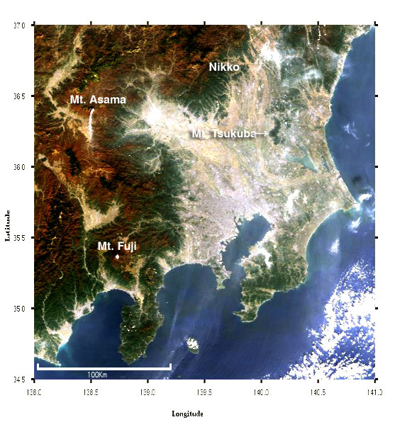
The MODIS sensor aboard NASA's Earth-observation satellites Terra and Aqua captured the volcanic activity of Mt. Asama that began on September 1, 2004, showing that it still continued. Figure 1 shows that the Kanto-Koshin district (around Tokyo and west of Tokyo) cleared up well, making it easy to find the white ash plume shooting up about 25 km southward from Mt. Asama in the upper left. You can also see the Nikko Mountains in the upper middle, Mt. Tsukuba in the upper right, and snow-capped Mt. Fuji in the lower left. The mountainous region where the altitude is high looks brownish, which means that the autumn tints are progressing there.
Figure 2 shows by animation that the ash plume at Mt. Asama gradually cleared from November 5 to December 3. The situation changed day-by-day, showing when there was ash plume, its length, and its drifting direction. The ash plume was prolonged more in the south and southeast by the monsoon. If you live in the area to the leeward of Mt. Asama, you need to be cautious about the volcanic ash. Around Japan, four tectonic Plates come into contacts with each other (*1): the North American Plate, the Pacific Plate, the Philippine Sea Plate, and the Eurasian Plate. The Philippine Sea Plate is slipping under the Eurasian Plate, while the Pacific Plate is slipping under the North American Plate and the Philippine Sea Plate, all at the speed of several centimeters a year. Because of the frictional heat accompanying this slipping (called "subduction"), plates begin to directly melt, or moisture is produced and melts plates, then magma is formed. As the density of magma is lighter than its surroundings, it rises upwards to form a volcano. Since the Japanese Islands are located on areas of subduction, there are many volcanoes in Japan. One tenth of all active volcanoes are located in Japan, from among the approximately 800 active volcanoes throughout the world (*2). Our Japanese ancestors began to live in the Japanese Islands some twenty to thirty thousand years ago (*3). Since then, we have been afflicted by the constant dangers and damages from volcanoes and their volcanic ash, but we have also received the benefit of tourist resources such as beautiful scenery and hot springs, and also the benefit of their underground resources such as mineral water. Thus, over the centuries, we have learned to live together with the volcanoes. The bibliography and site: (*1) JMA's description site (Japanese only) (*2) Tsuneji Rikitake, "An Outline of Earth Sciences" Seibunsha Co. 1992 (Japanese only) (*3)The National Science Museum's site "Prehistoric Long Journey of Japanese" (Japanese only)
Related sites: (Proceed to "250 m" then to "Tokyowan." Mt. Asama is located in the upper left of the images.) |
|||||||||||||||||||||||||||||||||||