Seen from Space 2004
Movement of the Kuroshio Current
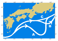
The Kuroshio Current, also called the Japan Current, is the second strongest current in the world after the Gulf Stream (*1) and is famous for its strong, fast flow. The Kuroshio Current is part of a big, warm current circulating in the North Atlantic Ocean. It enters the East China Sea near Yonagunijima, and moves northward west of Okinawa to the Pacific Ocean through the Tokara strait between Tanegashima, Yakushima, and Amamioshima. It also flows along the south coast of Japan to the east of Bousouhanto (Fig. 2).
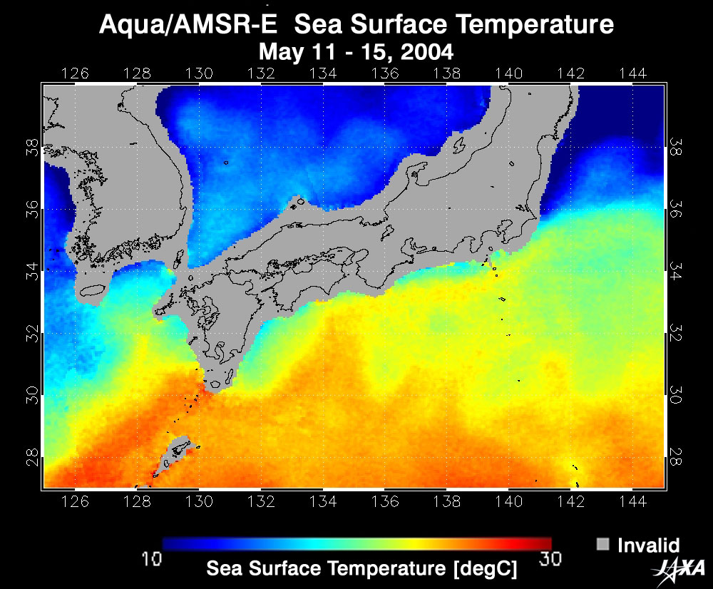
A recent report by the Japan Meteorological Agency (JMA) describes occasional changes in the Kuroshio Current as it flows along the south coast of Japan. It can snake far to the south of Tokai (Fig. 2-A), snake a little in the sea around Kanto (Fig. 2-B), or move straight near the south coast of Japan (Fig. 2-C). Although the cause of the snaking is unknown, it is possible to predict the movement of the Kuroshio Current from the distribution of sea-surface temperatures acquired by satellites. Figure 1 indicates a five-day-mean sea-surface temperature from May 11 to 15, 2004 in the southern Sea of Japan acquired by the Advanced Microwave Scanning Radiometer for EOS-PM (AMSR-E) (*2) aboard the Aqua satellite. The northern limit of high temperature over 25°C,colored in red, represents the flow of the Kuroshio Current. JMA reported small-scale snaking of the Kuroshio Current east of Kyushu last December and that it is moving eastward. It reached Ashizuri-misaki in early April, and Muroto-misaki in early May. In late May, it approached Shiono-misaki, far off southern Shikoku. JMA predicts the Kuroshio Current will snake eastward now and reach Tokai in July (*4). Information regarding the movement of the Kuroshio Current is necessary for people involved in fishing, marine sports, the safety of marine navigation, and disaster prevention along the coast. The route of the Kuroshio Current influences fish hauls because fishing points for bonito and tuna following the Kuroshio Current can change. The Earth Observation Research and Application Center (EORC) continues to track the movement of the Kuroshio Current by monitoring the distribution of sea-surface temperatures from satellites (>>See latest images). (*1) Kuroshio Current can exceed speeds of 2 m/s and can reach a width of 100 km. The water volume of the Kuroshio Current is 5,000 t/s. By comparison, the Gulf Stream's estimated flow is 2 to 2.5 m/s; the width, 80 km; the thickness, 2,000 m; and the volume of water, 80 million t/s. (*2) AMSR-E is a microwave sensor capable of accurately acquiring weak radiation from the land surface and atmosphere with its wide frequency bands to obtain necessary data for studying the Earth's hydrologic circulation. A microwave sensor, unlike an optical sensor, can observe night and day, regardless of cloud cover, and thus enables researchers to monitor the movement of the Kuroshio Current. (*3) Gray areas appearing in the sea area in the animation indicate a lack of data area due to rain clouds with heavy rain. The red area depicts a high-temperature area around the Izu islands and includes noise. (*4) Major snaking of Kuroshio Current has occurred six times since 1953, and the latest occurrence was from December 1989 to May 1991.
Related sites: |
||||||||||||||||