Seen from Space 2004
Dangerous Soil Cracks Through California
-- The San Andreas Fault --
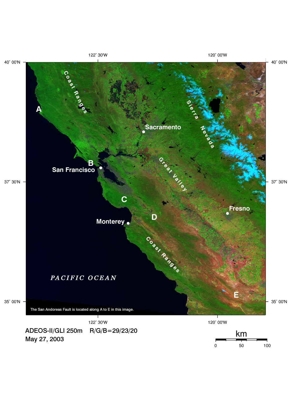
On April 18, 1906, about a hundred years ago, an unprecedented strong earthquake with a magnitude of 8.3(*1) hit the West Coast of San Francisco.. It was reported that several-meter slip faults were found in scattered pasture areas near fences and roads. Later, it became clear that the San Andreas Fault had some connection to the strong earthquake. The San Andreas Fault runs north to south through California with a length of over a thousand kilometers, the distance from Tokyo to Fukuoka(*2).The base rocks on both sides of this fault have four or five centimeter-long slip faults a year(*3). Some parts of this long fault are likely to have slips, while others are not. It is expected that the latter cause strong earthquakes by gradually accumulating the distortion. On October 17, 1989, a strong earthquake with a magnitude of 7.1(*1) again hit California. It significantly interrupted modern life by destroying infrastructure, such as highways. An image of the western United States was acquired by GLI on Midori-II. The San Andreas Fault is located along A to E in the image. Faults often can be seen as visible land forms such as valley slopes, cliffs, or straight mountain chains. From this image, we can see breaks of vegetation along the fault. Leafy mountain chains along the San Andreas Fault appear dark green. Agricultural irrigation has been employed in basins between the mountains. In the central valley, which includes the state capital of Sacramento, many farms appear in light green and can be seen sporadically in the large basin. Many kinds of crops are grown, including vegetables, cotton, and citrus fruits such as oranges. The rich harvests from California today are produced by the sun and are a product of ceaseless technical innovations, which have advanced in their competition with the large-scale agriculture of the east. Explanation of the image Sensor: Global Imager (GLI) Date of observation: May 27, 2003 This is a composite image generated from GLI spectral channel 29 (2210nm) in the short-wavelength infrared band (red), channel 23 (825nm) in the near-infrared band (green), and channel 20 (460nm) in the visible band (blue). (*1) From Science Chronology 2003. (*2) The San Andreas Fault consists of several small faults and is sometimes called the San Andreas Fault system. (*3) This base rock is called plate. The San Andreas Fault lies along the boundary between the Pacific plate and the North American plate. It is classified as a "transform fault" that has slip faults produced by grazing of plates. In this area, the Pacific plate is shifting northwestwards, and the North American plate is shifting southeastwards. |