Seen from Space 2003
| Public Release of Standard Products from GLI and AMSR on Midori-2 |
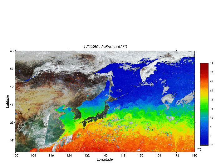
On December 24, 2003, the Japan Aerospace Exploration Agency (JAXA) will begin releasing standard products derived from the Advanced Microwave Radiometer (AMSR) and the Global Imager (GLI) on Midori-2, which was launched on December 14, 2002, based on data acquired from April 2, 2003 to October 24, 2003. GLI is multipurpose sensor for conducting research on the atmosphere, oceanography, land and the cryosphere. By using many channel combinations, GLI produces numerous geophysical parameters, including cloud top height and chlorophyll-a concentration. The example animation shows the Ocean standard product of sea surface temperature from April 2 to October 16, 2003 (every eight days) (*). AMSR is a microwave radiometer that receives weak microwave signals emitted from the atmosphere and land surfaces and produces geophysical parameters, such as water vapor and sea-surface temperature. The example image shows the standard product of the average water vapor of April, 2003. These products are expected to contribute to research into climate change and global warming. Please visit the following web site for more detailed information. ADEOS-II Related Information : http://www.eorc.jaxa.jp/en/about/distribution/info/adeos2.html Please refer to notices of the following each sensor's homepages when you use these products. GLI: http://sharaku.eorc.jaxa.jp/GLI/data/data_re.html AMSR: http://sharaku.eorc.jaxa.jp/AMSR/data_re/index.html (*)Please note that the animation is not a standard product. |