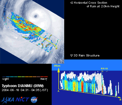
These are images of typhoon DIANMU acquired by TRMM. The left image shows clouds detected by VIRS and the distribution of precipitation detected by PR at an altitude of 2km. The right image, observed by PR, shows the structure and the cross section of precipitation along line A-B of the left image. Though the area is distant from the eye of typhoon, you can see that the top of the precipitation reaches 10km high and heavy rain is falling.
Okinawa and Kyushu entered a stormy region of Typhoon DIANMU. The typhoon made landfall near Muroto-city, Kochi Prefecture. It then passed through the Kinki region and the Sea of Japan, causing widespread damage in western Japan where two people died, three were missing, and 87 were injured. According to the JMA, the five typhoons that developed in June represent a record since the Meteorological Agency started recording typhoon data. In addition, Typhoons CONSON and DIANMU, two typhoons that struck the main island of Japan during June,
|