 |
|
| 1 |
| A Concentrated Heavy Rain over Korea |
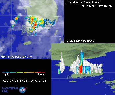
These are images of concentrated heavy rain over Korea observed by TRMM Precipitation Radar (PR) on July 31,1998 during the period 10:12 pm to 10:16 pm (JST). The heavy rain front in middle and eastern China moved to the east without weakening, bringing great damage, landslide casualties, and muddy streams to the southern part of Korea. According to the newspaper, the highest recorded precipitation was 226 mm in Soon Cheon, Cheon Ra Nam-Do. 202mm of precipitation occurred in San Cheong, Kyung Sang Nam-Do, and 103mm in Hae Nam, Cheon Ra Nam-Do. These precipitation estimates are for the night of July 31 up to 7pm on August 1. A record Korean precipitation rate of 128 mm/hour was also observed in Soon Cheon, Cheon Ra Nam-Do. In Japan usually the end of the rainy season is announced on an annual basis. However, this did not occur this year in the Tohoku and Hokuriku regions in Japan because of abnormal weather. Other examples of abnormal weather such as heavy rains in Niigata, Japan, and a flood in Chang Jiang, China may have been caused by the presence of a historically anomalous El Nino. TRMM data are expected to be useful for investigations of these abnormal weather phenomena. Left image shows the horizontal distribution of rain at an altitude of 2.0km. TRMM PR observations indicate the precipitation system produced rainfall at a rate greater than 30 mm/hour. The image also identifies occurrences of heavy rain in the area. Right image shows the vertical cross section of rain. This example highlights the fact that with TRMM PR it is possible to observe rain rates at different heights in precipitation systems. In this case, the image presents rain rate information for different heights along a 14 km vertical column. |