Ishigakijima Island and Miyakojima Island are located in the most
south-western area in Japan and are surrounded by open oceans. Since the first
priority Tropical Rainfall Measuring Mission (TRMM) objective is to measure
tropical rainfall over the ocean, Ishigakijima and Miyakojima area is the most
suitable site for TRMM validation in Japan. The campaign experiment was
conducted in this area's rainy season, that is, from the middle of May to the
middle of June.
TRMM, which was launched from NASDA's Tanegashima Space Center on November
29, 1997, is a joint venture between Japan and the US. TRMM has several rain
sensors: a precipitation radar (PR), microwave and visible/infrared radiometers
(TMI and VIRS), lightning sensor (LIS) and Earth radiant sensor (CERES). The PR,
which was developed in Japan, is the first spaceborne rain radar and makes TRMM
a unique mission.
Japan's TRMM validation activity, which emphasizes on PR validation, is
closely related to the TRMM PR team. The Japan Meteorological Agency's (JMA's)
routinely accumulated data, such as AMeDAS and radar-AMeDAS composite rain maps,
is used for this validation activity. Along with the routine data, a field
campaign was conducted. The major field campaign was "Ishigaki/Miyako
Campaign Experiment for TRMM (IMCET)." IMCET '98 was conducted in
cooperation with JMA and Communications Research Laboratory (CRL) from May 20 to
June 10, 1998. In this experiment, CRL airborne multi-parameter radar (CAMPR-D)
and JMA's Ishigakijima radar played the major roles. The first step in the PR
validation is a radar reflectivity comparison. The rainfall rate comparison has
some issues, such as the raindrop size distribution variations. Thus, we first
tried to compare the radar reflectivity measured by the PR and ground-based or
airborne radars. Ground-based Doppler radars are also planned to be employed in
IMCET '99. The three-dimensional radar reflectivity structure at the time of
TRMM overpass is the most important data set for the PR algorithm validation.
The precipitation system development itself was thus studied using enhanced
sonde operation.
The PR rain estimate algorithm has many steps including measured radar
reflectivity deduction and rain attenuation correction using several methods. We
can validate the PR rain estimate algorithms using the three-dimensional radar
reflectivity data. Profiling the dynamic structure of rain systems, such as the
profile of latent heat release, is also one of the major goals of IMCET.
1.2 Experimental Field and Instruments
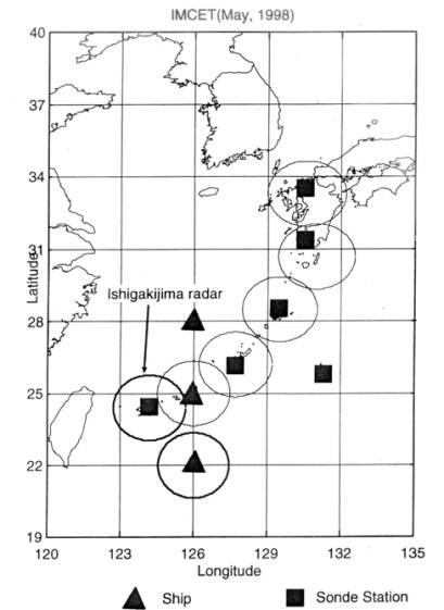
Under the major validation programs for the PR, IMCET'98 was conducted around
Miyakojima Island of Japan for nearly 20 days in May and June 1998. During the
experiment campaign, JMA's ground-based radars, the airborne rain radar (CAMPR-D)
and a shipborne radar were employed. Enhanced radiosonde operations were also
performed. CAMPR-D has a dual-beam capability. Figure 1.1 shows the coverage of
JMA's radars. The IMCET region is covered by Ishigakijima and Okinawa radars.
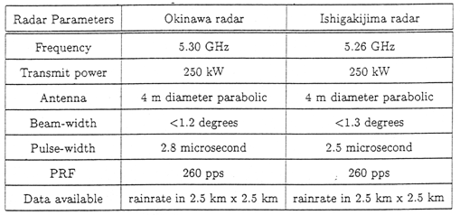
Specifications of JMA's radars are shown in Table 1.1. The Okinawa radar is
located at 26 deg. 08 min. North, 127 deg. 45 min. East; the Ishigakijima radar
is located at 24 deg. 10 min. North, 124 deg. 20 min. East in the chain of
islands in the southwest of Japan. The Miyakojima area is surrounded by ocean
and is very useful for the rain observation over ocean. Since one of the PR
products is the rain observation over oceans, this area is suitable for
comparing satellite data with ground truth data. TRMM is the first space mission
dedicated to quantitatively measuring tropical and subtropical rainfall. The
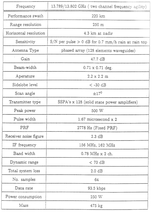
major PR parameters are listed in Table 1.2. Standard products of the PR have
been generated routinely at the Earth Observation Center (EOC), National Space
Development Agency of Japan (NASDA) and at the Goddard Space Flight Center (GSFC),
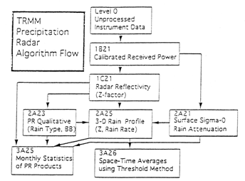
National Aeronautics and Space Administration (NASA). Figure 1.2 shows the data
processing flow for the standard algorithm.
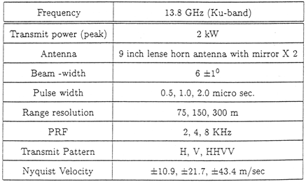
Specifications of CAMPR-D are shown in Table 1.3. CAMPR-D and the PR have
similar rain measurement geometry in the sense that both observe rain from
above. They also employ signals of nearly the same frequency so many aspects of
the PR are expected to be validated using CAMPR-D. Another objective of this
experiment was to calibrate the airborne radar for measuring the sea-surface
because the sea-surface is considered to be a good calibration source.
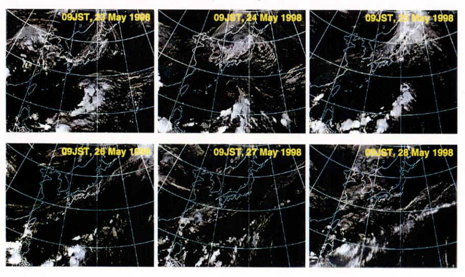
During IMCET '98, May 26 and 27 were the most rainy days, as can be seen
clearly from GMS images in Figure 1.3. Some rain events were also experienced on
May 30, 1998. Ground-based radars performed the Plan Position Indicator (PPI)
scanning. The rain was monitored by the ground-based radars and the aircraft was
navigated towards the rain region. Then CAMPR-D observation was conducted at the
same time and location as the PR observation.
Fig. 1.1 Intensive observation area of IMCET. Circles indicate coverage
of each radar
Table 1.1 Specifications of JMA's radars.
Table 1.2 Major system performance and specifications of TRMM
PR.