Kinji Furukawa : National Space Development Agency of Japan
4.1 Simultaneous observations by the PR and ground-based radars
The radar reflectivity observed by the PR should be validated by comparison with ground observations. In the Ishigaki/Miyako Campaign Experiment for TRMM (IMCET), the Japan Meteorological Agency's (JMA's) two ground-based radars (Okinawa and Ishigakijima) succeeded in making several simultaneous observations with the PR. This section seeks to validate the PR data using these ground data.
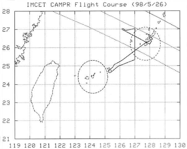
The TRMM orbit with the PR swath width, the CAMPR-D (see the section 3) trajectory, and the coverage of the Okinawa and Ishigakijima radars within a radius of about 100 km diameter for May 26, 1998 are shown in Figure 4.1. In this case, there was a large rain area northwest of Okinawa. The PR observed the overlapping area with the Okinawa radar at around 11:23 Japan Standard Time (JST). The attenuation-corrected radar reflectivity factor (Ze) at 2.5 km height obtained around 11:23 a.m. (JST) by the PR is shown in Figure 4.2 (a), and the Z factor observed by the Okinawa radar is shown in Figure 4.2 (b). On May 30, 1998 at 03:18 a.m., the PR and the Ishigakijima radar observed overlapping areas. At that time, there was an expanding precipitation system south of Ishigakijima. Figure 4.3 (a) shows the distribution of radar reflectivity observed by the PR, and (b) shows that observed by the Ishigakijima radar. In these two cases, though there are some differences in absolute value of the Z factor, the horizontal distribution is apparently quite similar. Other data observed in IMCET'98 are presented in the section 6.
4.2 Comparison results between the PR and the ground-based radar
The horizontal distribution is apparently quite similar in the two simultaneous observations by the PR and ground-based radars. However, there are some differences in the absolute value of the Z factor, so we have to consider the reasons for the discrepancies.
First, the ground-based radar observes only a few elevations, so the data at a fixed height seem like concentric circles centered on the ground-based radar (Figure 4.4). In Figures 4.2 (b) and 4.3 (b), the gap is filled by the lower height data for the rain pattern comparison. In these cases, we assumed there were no drastic changes in the vertical structure of the rain, so the error caused by the vertical structure change which we can see in the CAMPR-D data (see the section 3) is included. Furthermore, the ground-based radar takes about 7.5 minutes for 1 volume scan, but the PR observes the same area in only a few seconds. The error caused by this absolute time difference is included, too.
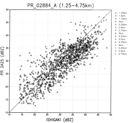
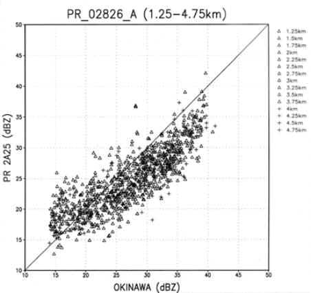
Considering these errors, we tried to perform a quantitative comparison. To exclude errors from the vertical structure of the rain, we used only the concentric circle data as the ground-based radar data to make scatter diagrams. Because of the difference of the direction of observation, the rain attenuation is different, so we use the attenuation-corrected radar reflectivity factor (Ze) as the PR data in the level 2 product. It is difficult to estimate the effect of the attenuation from the rain for ground-based radar data. In this case, the rain was not so heavy as to cause drastic attenuation, so we used the raw data for this comparison.
Considering the time and space differences, we averaged radar reflectivity in 10 km by 10 km boxes. Using these data, we plotted scatter diagrams of radar reflectivity for the PR and the ground-based radars. Figure 4.5 is a scatter diagram of the radar reflectivity for the PR and Okinawa radar for the case indicated in Figure 4.2. Figure 4.6 is the scatter diagram for the PR and Ishigakijima radar shown in Figure 4.3. Roughly speaking, the PR and the ground-based radars agree well in both cases, though there is an obvious bias in the Okinawa radar's data. The Okinawa radar tends to detect a larger radar reflectivity than the PR. Also, the regression line deviates from an inclination of 45 degrees. Other results from the data observed in IMCET'98 are presented in the section 6. In these cases, it is difficult to quantitatively validate the PR data by one-to-one comparison of 10km averaged data which has large variances. This disagreement is caused by the absolute time difference of two observations, the effect of the data processing filters applied in JMA's radars to eliminate the interference, and so on. For the absolute observing time difference, we should use only one elevation scan or one azimuth scan close to the PR observation time. However, we didn't adopt this way in this section. For the effect of the filters, we should consider calibrating the radar and estimating the effect of the filters. For these purposes, we conducted an engineering check of the Ishigakijima radar jointly with JMA. As a result, we found that Ishigakijima radar appears to be fairly well calibrated within 1dB without filters. The data processing filters applied in JMA radars are the Moving Target Indicator (MTI) filter, the two-pictures comparing filter, and the sweep comparing filter. To estimate the effect of these filters, we observed rain in the "on" and "off" state of each filter. These experimental observations revealed the apparent effects of the filters. For example, Figure 4.7 (a) shows the rain echo with the MTI filter "on," and (b) shows the rain echo with "off." We can see some differences in both data, but these differences might change for each precipitation system. It is thus difficult to estimate the absolute value of the effect of the filters.
We should compare the averaged value of data including these errors because we can not separate these errors from true value. This analysis demonstrated that the Ishigakijima radar detects about a 0.13 dBZ larger value than the PR and that the Okinawa radar detects about a 2.67 dBZ larger value than the PR. Considering that the PR is calibrated to about 1 dB and has stable performance, we can conclude that the Okinawa radar detects about 2.54 dBZ lager value than the Ishigakijima radar including the effects of filters. This result is consistent with the fact that the Okinawa radar detects a larger value than the Ishigakijima radar in the overlapping area of the two radars.
The purpose of this analysis is to validate the PR data using ground-based radar data, but the result shows that we can compare two separated ground-based radars using the PR. This means that we can use the PR as the "space calibrator" for ground-based radars. This will be the another way of using the PR data.In this section, we showed some comparison results between the PR and the ground-based radar using the data observed in the Ishigaki/Miyako campaign experiment for TRMM. The rain pattern observed by the PR and the ground-based radar agreed well. However we concluded that it is difficult to validate the PR data quantitatively using JMA's ground-based radar data. For this purpose, we should use a well-calibrated high-resolution ground-based radar without data processing filters. We further concluded that the PR data can be used as a "space calibrator" for separated ground-based radars. This will be another way of using the PR data.
Fig. 4.1 Trajectory of the airborne radar (CAMPR-D) and the coverage of Okinawa weather radar (upper right) and Ishigakijima radar (near center) operated by JMA.
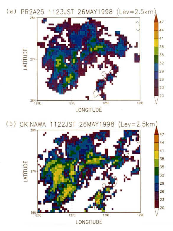
Fig. 4.2 Horizontal pattern of radar reflectivity (attenuation corrected) by the PR (a) and Okinawa ground based radar (b) at 2.5km height taken almost at the same time.
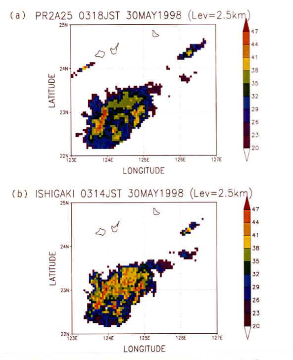
Fig. 4.3 Horizontal pattern of radar reflectivity (attenuation corrected) by the PR (a) and Ishigakijima ground based radar (b) at 2.5km height.
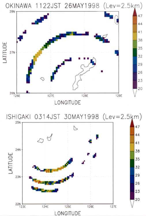
Fig. 4.4 The ground-based radar data at a fixed height. This seems like concentric circles centered on the ground-based radar.
|
|
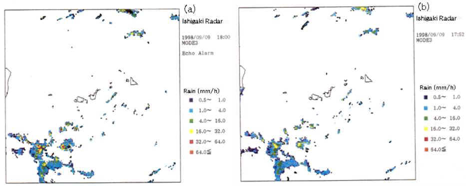
Fig. 4.7 The rain echo observed by Ishigakijima radar with the MTI filter "on" (a) and "off" (b).