Evolution of El Nino in 2002
Since the El Nino event of 1997 and 98 was the largest on record, sea surface temperatures over the central and eastern equatorial Pacific were 4 to 5oC higher than normal. The El Nino event is now relatively small, and the peak sea surface temperature anomalies are located over the central equatorial Pacific.
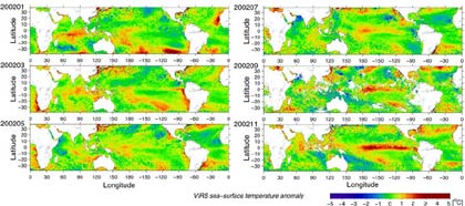
| VIRS sea-surface temperature anomaly | |
 |
|
| This image presents monthly mean SST anomalies estimated by TRMM Visible Infrared Scanner (VIRS). After the beginning of 2002, SSTs above those of normal years over the western tropical Pacific slowly shifted eastward. In November, an SST 2 to 3°C higher than normal is found over the central and eastern equatorial Pacific, and El Nino reached its mature stage. |
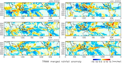
| TRMM merged rainfall anomaly | |
 |
|
| This image shows monthly mean rainfall anomalies estimated by the "TRMM and Others Combined" algorithm (TRMM, IR on board geostationary satellites and rain gauges). It is clear that the variation of the SST distribution corresponds well to the changes in the distribution of rainfall all over the world. In July, more rain was over the far south of Japan, and was related to the evolution of typhoons in this area. In September, peaks of rainfall were found over the central tropical Pacific, and in November, the position of the Inter-Tropical Convergence Zone (ITCZ) shifted further southward than in a normal year. |
- Evolution of El Nino in 1997/98
- Evolution of El Nino in 2002