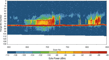
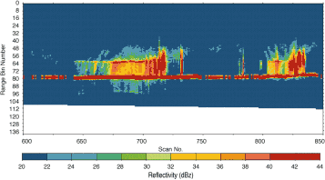
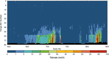
Figure shows vertical structure of rainfall observed by PR on December 21, 1997 from Uruguay to northern Argentine. The upper panel is the example of PR 1B21 product, the middle panel is 1C21 product and the lower panel is 2A25 product. The horizontal axis of each figure indicates relative Scan Number, which corresponds to distance along TRMM flight direction (1scan = 4.3 km). The vertical axis of each figure indicates Range Bin Number, which corresponds to relative distance from satellite (1 Range Bin = 250 m).
PR 1B21 output includes received power. PR 1C21 output includes non-validated radar reflectivity. PR 2A25 output includes rain rate profile and radar reflectivity that is corrected using rain attenuation value (lower figure shows rain rate profile). Like this, received power, radar reflectivity, and rain profile are calculated successively for each normalized radar surface cross section within IFOV.