1. Correspondence between SGLI NRT and MODIS NRT (Aug. 09, 2019 Update)
| No. | Geophysical Variables | Filename
YYYY:year, MM:month, DD:day, hh:hour, mm:minutes (Start time of the data)
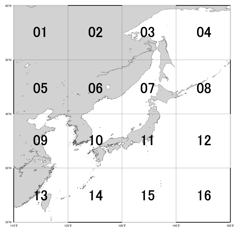
PPP:Path number, X: Process flag(L:Near-realtime(Japan station),N:Near-realtime(Svalbard station),G:Standard) VVVV:Algorithm version, NN:Area number (View Fig.1 and Fig.2) |
Variable name | Format | Day /Night |
Sample data | ||
|---|---|---|---|---|---|---|---|---|
| Attribute value | Explanation | |||||||
| 1 | Top of the atmosphere (TOA) radaince | GC1SG1_YYYYMMDDhhmm0PPP00_1BMX_VNRDQ_VVVV_Lt_VN01_NN.nc | TOA radiance of VN01 | Radiance at VN01 (380nm) | netCDF | D | Area 11, ALL |
RGB Image R:VN08 G:VN05 B:VN03 |
| 2 | GC1SG1_YYYYMMDDhhmm0PPP00_1BMX_VNRDQ_VVVV_Lt_VN02_NN.nc | TOA radiance of VN02 | Radiance at VN02 (412nm) | netCDF | D | Area 11, ALL | ||
| 3 | GC1SG1_YYYYMMDDhhmm0PPP00_1BMX_VNRDQ_VVVV_Lt_VN03_NN.nc | TOA radiance of VN03 | Radiance at VN03 (443nm) | netCDF | D | Area 11, ALL | ||
| 4 | GC1SG1_YYYYMMDDhhmm0PPP00_1BMX_VNRDQ_VVVV_Lt_VN04_NN.nc | TOA radiance of VN04 | Radiance at VN04 (490nm) | netCDF | D | Area 11, ALL | ||
| 5 | GC1SG1_YYYYMMDDhhmm0PPP00_1BMX_VNRDQ_VVVV_Lt_VN05_NN.nc | TOA radiance of VN05 | Radiance at VN05 (530nm) | netCDF | D | Area 11, ALL | ||
| 6 | GC1SG1_YYYYMMDDhhmm0PPP00_1BMX_VNRDQ_VVVV_Lt_VN06_NN.nc | TOA radiance of VN06 | Radiance at VN06 (565nm) | netCDF | D | Area 11, ALL | ||
| 7 | GC1SG1_YYYYMMDDhhmm0PPP00_1BMX_VNRDQ_VVVV_Lt_VN07_NN.nc | TOA radiance of VN07 | Radiance at VN07 (673.5nm) | netCDF | D | Area 11, ALL | ||
| 8 | GC1SG1_YYYYMMDDhhmm0PPP00_1BMX_VNRDQ_VVVV_Lt_VN08_NN.nc | TOA radiance of VN08 | Radiance at VN08 (673.5nm) | netCDF | D | Area 11, ALL | ||
| 9 | GC1SG1_YYYYMMDDhhmm0PPP00_1BMX_VNRDQ_VVVV_Lt_VN09_NN.nc | TOA radiance of VN09 | Radiance at VN09 (763nm) | netCDF | D | Area 11, ALL | ||
| 10 | GC1SG1_YYYYMMDDhhmm0PPP00_1BMX_VNRDQ_VVVV_Lt_VN10_NN.nc | TOA radiance of VN10 | Radiance at VN10 (868.5nm) | netCDF | D | Area 11, ALL | ||
| 11 | GC1SG1_YYYYMMDDhhmm0PPP00_1BMX_VNRDQ_VVVV_Lt_VN11_NN.nc | TOA radiance of VN11 | Radiance at VN11 (868.5nm) | netCDF | D | Area 11, ALL | ||
| 12 | GC1SG1_YYYYMMDDhhmm0PPP00_1BMX_IRSDQ_VVVV_Lt_SW01_NN.nc | TOA radiance of SW01 | Radiance at SW01 (1050nm) | netCDF | D | Area 11, ALL | ||
| 13 | GC1SG1_YYYYMMDDhhmm0PPP00_1BMX_IRSDQ_VVVV_Lt_SW02_NN.nc | TOA radiance of SW02 | Radiance at SW02 (1380nm) | netCDF | D | Area 11, ALL | ||
| 14 | GC1SG1_YYYYMMDDhhmm0PPP00_1BMX_IRSDQ_VVVV_Lt_SW03_NN.nc | TOA radiance of SW03 | Radiance at SW03 (1630nm) | netCDF | D | Area 11, ALL | ||
| 15 | GC1SG1_YYYYMMDDhhmm0PPP00_1BMX_IRSDQ_VVVV_Lt_SW04_NN.nc | TOA radiance of SW04 | Radiance at SW04 (2210nm) | netCDF | D | Area 11, ALL | ||
| 16 | GC1SG1_YYYYMMDDhhmm0PPP00_1BMX_IRSDQ_VVVV_Lt_TI01_NN.nc GC1SG1_YYYYMMDDhhmm0PPP00_1BMX_IRSNQ_VVVV_Lt_TI01_NN.nc |
TOA radiance of TI01 | Radiance at TI01 (10.8μm) | netCDF | D/N | Area 11, ALL | ||
| 17 | GC1SG1_YYYYMMDDhhmm0PPP00_1BMX_IRSDQ_VVVV_Lt_TI02_NN.nc GC1SG1_YYYYMMDDhhmm0PPP00_1BMX_IRSNQ_VVVV_Lt_TI02_NN.nc |
TOA radiance of TI02 | Radiance at TI02 (12.0μm) | netCDF | D/N | Area 11, ALL | ||
| 18 | Normalized Water Leaving Radiance |
GC1SG1_YYYYMMDDhhmm0PPP00_L2MX_NWLRQ_VVVV_NWLR_380_NN.nc | Normalized Water Leaving Radiance(NWLR) at 380.0 nm | NWLR at 380.0nm | netCDF | D | Area 11, ALL |
RGB Image R:NWLR_670 G:NWLR_565 B:NWLR_490 |
| 19 | GC1SG1_YYYYMMDDhhmm0PPP00_L2MX_NWLRQ_VVVV_NWLR_412_NN.nc | Normalized Water Leaving Radiance(NWLR) at 412.0 nm | NWLR at 412.0nm | netCDF | D | Area 11, ALL | ||
| 20 | GC1SG1_YYYYMMDDhhmm0PPP00_L2MX_NWLRQ_VVVV_NWLR_443_NN.nc | Normalized Water Leaving Radiance(NWLR) at 443.0 nm | NWLR at 443.0nm | netCDF | D | Area 11, ALL | ||
| 21 | GC1SG1_YYYYMMDDhhmm0PPP00_L2MX_NWLRQ_VVVV_NWLR_490_NN.nc | Normalized Water Leaving Radiance(NWLR) at 490.0 nm | NWLR at 490.0nm | netCDF | D | Area 11, ALL | ||
| 22 | GC1SG1_YYYYMMDDhhmm0PPP00_L2MX_NWLRQ_VVVV_NWLR_530_NN.nc | Normalized Water Leaving Radiance(NWLR) at 530.0 nm | NWLR at 530.0nm | netCDF | D | Area 11, ALL | ||
| 23 | GC1SG1_YYYYMMDDhhmm0PPP00_L2MX_NWLRQ_VVVV_NWLR_565_NN.nc | Normalized Water Leaving Radiance(NWLR) at 565.0 nm | NWLR at 565.0nm | netCDF | D | Area 11, ALL | ||
| 24 | GC1SG1_YYYYMMDDhhmm0PPP00_L2MX_NWLRQ_VVVV_NWLR_670_NN.nc | Normalized Water Leaving Radiance(NWLR) at 673.5 nm | NWLR at 673.5nm | netCDF | D | Area 11, ALL | ||
| 25 | Photosynthetically Available Radiation | GC1SG1_YYYYMMDDhhmm0PPP00_L2MX_NWLRQ_VVVV_PAR_NN.nc | Photosynthetically Available Radiation | PAR | netCDF | D | Area 11, ALL |
Browse Image |
| 26 | Aerosol Optical Thickness | GC1SG1_YYYYMMDDhhmm0PPP00_L2MX_NWLRQ_VVVV_TAUA_670_NN.nc | Aerosol Optical Thickness(TauA) at 673.5 | TauA at VN07 (673.5nm) | netCDF | D | Area 11, ALL |
Browse Image (673.5nm) |
| 27 | GC1SG1_YYYYMMDDhhmm0PPP00_L2MX_NWLRQ_VVVV_TAUA_865_NN.nc | Aerosol Optical Thickness(TauA) at 868.5 | TauA at VN10 (865.5nm) | netCDF | D | Area 11, ALL | ||
| 28 | Floating Algae Index | GC1SG1_YYYYMMDDhhmm0PPP00_L2MX_NWLRQ_VVVV_FAI_NN.nc | Floating Algae Index | FAI | netCDF | D | Area 09, |
Browse Image |
| 29 | Ocean Color | GC1SG1_YYYYMMDDhhmm0PPP00_L2MX_IWPRQ_VVVV_CDOM_NN.nc | Colored dissolved organic matter (CDOM) at 443nm | Colored dissolved organic matter | netCDF | D | Area 11, ALL |
Browse Image (CHLA) |
| 30 | GC1SG1_YYYYMMDDhhmm0PPP00_L2MX_IWPRQ_VVVV_CHLA_NN.nc | Chllorophyll-a concentration (CHLA) | Chlorophyll-a concentration | netCDF | D | Area 11, ALL | ||
| 31 | GC1SG1_YYYYMMDDhhmm0PPP00_L2MX_IWPRQ_VVVV_TSM_NN.nc | Total suspended matter (TSM) | Total suspended matter | netCDF | D | Area 11, ALL | ||
| 32 | Sea Surface Temperature | GC1SG1_YYYYMMDDhhmm0PPP00_L2MX_SSTDQ_VVVV_NN.nc GC1SG1_YYYYMMDDhhmm0PPP00_L2MX_SSTNQ_0006_NN.nc |
Sea Surface Temperature[SST] | Sea Surface Temperature | netCDF | D/N | Area 11, ALL |
Browse Image (Day) |
| 33 | Sea-ice and snow cover distribution |
GC1SG1_YYYYMMDDhhmm0PPP00_L2MX_OKIDQ_VVVV_NN.nc |
|
Sea-ice and snow cover distribution | netCDF | D | Area 11, ALL |
Browse Image |
- Note1: Obs_time, Sensor_zimuth, Sensor_zenith, Solar_azimuth, Solar_zenith, Land_water_flag and QA_flag are stored in "(L1B filename)_GEOT.nc" as geometric and quality information data.
- Note2: Obs_time and QA_flag are stored in "(Level-2 products filename)_GEOT.nc" as geometric and quality information data.
- Note3: Spatial resolution of all SGLI near realtime data is 250 meter.
- Note4: Format of SGLI near realtime data is netCDF4.
- Note5: "NN" in the filename denotes the number of tiling areas or "Japan".
| No. | Geophysical Variables | Filename | Explanation | Format | Day /Night |
Correspondence |
|---|---|---|---|---|---|---|
| 1 | Sea Surface Temperature | A2GL1*_08000_05300_sst.gz | Binary data convereted from the output of level-2 SST algorithm (fixed region) | Binary with 1-line header | D/N | Table 1- No.31 |
| 2 | A2GL1*(scene size)_sst.gz | Binary data convereted from the output of level-2 SST algorithm (scene) | Binary with 1-line header | D/N | ||
| 3 | A2GL1*sst_nn.gz | Tiled binary data converted from the output of level-2 SST algorithm (12 tiles) | Binary with 1-line header | D/N | Table 1- No.31 | |
| 4 | Chlorophyll-a concentration | A2GL1*chla.gz | Binary data convereted from the output of level-2 Chlorophyll-a algorithm | Binary with 1-line header | D | Table 1- No.29 |
| 5 | A2GL1*chla_nn.gz | Tiled binary data converted from the output of level-2 Chlorophyll-a algorithm (12 tiles) | Binary with 1-line header | D | Table 1- No.29 | |
| 6 | M?D02HKM*_Japan_chla.gz | Output of Chlorophyll-a algorithm at 500 m spatial resolution (Japan area) | Binary with 1-line header | D | Not available | |
| 7 | M?D02HKM*_AreaName_chla.gz | Output of Chlorophyll-a algorithm at 500 m spatial resolution (local areas) | Binary with 1-line header | D | Not available | |
| 8 | Rayleigh-corrected reflectance and Chlorophyll-a concentration | M?D02HKM*SR16.hdf.gz | HDF formated output of Rayleigh-corrected reflectance and Chlorophyll-a algorithm at 500 m spatial resolution (around Japan) | HDF4 | D | Table 1- No.21-24 as alternatives |
| 9 | M?D02HKM*FR16.hdf.gz | HDF formated output of Rayleigh-corrected reflectance and Chlorophyll-a algorithm at 500 m spatial resolution (Fukutokuokanoba area) | HDF4 | D | Not available | |
| 10 | M?D02HKM*OR16.hdf.gz | HDF formated output of Rayleigh-corrected reflectance and Chlorophyll-a algorithm at 500 m spatial resolution (Ogasawara-Nishinoshima area) | HDF4 | D | Not available | |
| 11 | M?D02QKM*SR02.hdf.gz | HDF formated output of Rayleigh-corrected reflectance and Chlorophyll-a algorithm at 250 m spatial resolution (around Japan) | HDF4 | D | Table 1- No.21-24 as alternatives | |
| 12 | M?D02QKM*FR02.hdf.gz | HDF formated output of Rayleigh-corrected reflectance and Chlorophyll-a algorithm at 250 m spatial resolution (Fukutokuokanoba area) | HDF4 | D | Not available | |
| 13 | M?D02QKM*OR02.hdf.gz | HDF formated output of Rayleigh-corrected reflectance and Chlorophyll-a algorithm at 250 m spatial resolution (Ogasawara-Nishinoshima area) | HDF4 | D | Not available |
- Note1: "*" in the filename denotes observation date and times.
- Note2: "?" in the filename denotes satellite ID of MODIS (ie., "O" for Terra and "Y" for Aqua)

2. netCDF Viewer
-
Panoply netCDF, HDF and GRIB Data Viewer
https://www.giss.nasa.gov/tools/panoply/ -
HDFView
https://support.hdfgroup.org/products/java/hdfview/ -
QGIS
https://www.qgis.org/ja/site/forusers/.html
3. SGLI reference infomation
-
SGLI Standard Product and Algorithm
https://suzaku.eorc.jaxa.jp/GCOM_C/data/product_std_html -
G-portal
https://gportal.jaxa.jp/gpr/