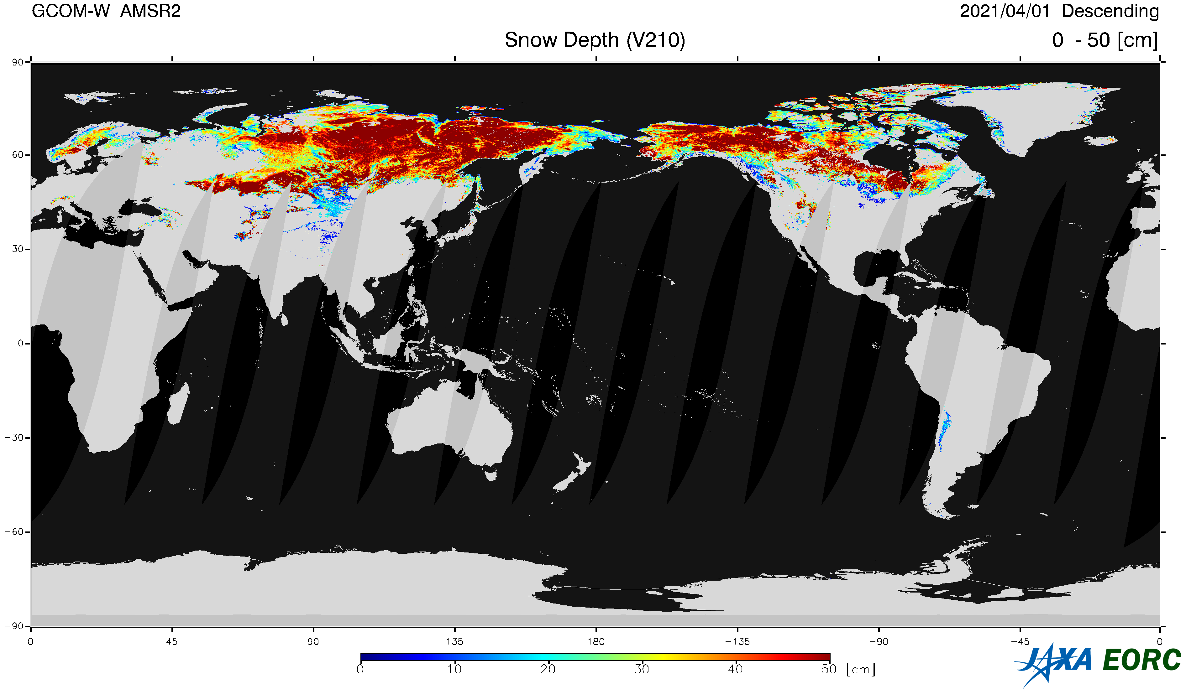
Snow Depth
(Standard Product, Research Product)
The Snow depth (SND) product stores depth of snow cover over land surface.
Coverage of the product is over land only, and unit is [cm].
We do not provide snow cover over the sea ice surface.
Snow depth parameter is closely related to climate variation, and this product enables us to figure out changes in distribution of global snow cover.

Product Overview
The new algorithm being developed for AMSR3 is applied to AMSR2 data and released as AMSR2 research products.
The research products are designed to improve the accuracy of snow depth estimation and snow coverage detection.
| Product Name | Snow Depth DOI |
|||
|---|---|---|---|---|
| Product Type | Standard Product | Research Product | ||
| Processing Level | L2 (Swath data *2) and L3 (Grid data: EQR, Polar stereo NH) | L2 (Swath data *2) and L3 (Grid data: EQR, Polar stereo NH) | ||
| Product ID | SND | SND | ||
| Spec. *1 | Satellite | AMSR3 | AMSR2 | |
| Area | Global over land | Global over land | Global over land | |
| Spatial Resolution | approx. 30 km | approx. 30 km | approx. 30 km | |
| Accuracy Requirement | 20 cm *3 | 20 cm *3 | 20 cm *3 | |
| Range | 0 〜100 cm | 0 〜100 cm | 0 〜100 cm | |
| Latest Version | AMSR3: ver. 0.0 2025-??-?? release AMSR2: ver. 2.1 2015-03-26 release
AMSR-E: ver. 8 2019-07-05 release |
AMSR2: ver. 1.0
2022-09-20 release
AMSR-E: ver. 1.0 2022-09-20 release |
||
| Product Period | AMSR3: ??? 2025 〜 AMSR2: July 2012 〜 AMSR-E: July 2002 〜 October 2011 |
AMSR2: July 2012 〜 AMSR-E: July 2002 〜 October 2011 |
||
| Data Download | Globe Portal System (G-Portal) |
AMSR Research Product Distribution Service | ||
| Data Format | NetCDF AMSR3 Higher Level Format ???KB HDF5 AMSR2 Higher Level Format 2.7MB AMSR-E Level2 Format description 757KB
AMSR-E Level3 Format description 1.03MB |
HDF5 AMSR2 Higher Level Format
2.7MB |
||
| Stored Data | (1) Snow Depth [cm] (2) Snow Water Equivalent [cm] |
(1) Snow Depth [cm] (2) Snow Water Equivalent [cm] |
||
| Data Quality Flag | AMSR3 L2 SND Quality Flag
???KB AMSR2 L2 SND Quality Flag 263KB |
L2 SND Quality Flag (SMSA ver. 3.0)
85KB |
||
| Algorithm Version |
AMSR3 v0.0 (Algorithm Description, ??MB PDF page ? )AMSR2 v2.0 3.9MB PDF page 86 |
SMSA v3.01 (R Kelly et al., 2019) | ||
| Validation Result | GOSAT-GW・AMSR3 Standard Product ??MB PDF page ? AMSR2 Product Update 12MB PDF page 43 |
Algorithm overview and validation result (SMSA 3.0)
454KB |
||
- The specifications are defined in the AMSR3 Mission Requirement and AMSR2 Mission Requirement. The required accuracy is the standard accuracy of standard product defined in the mission requirement.
- Swath data is a format in which data for each footprint is stored in a two-dimensional array (observation points in scanning direction x number of scanning lines) in order of observation time.
- Except ice sheets and dense forest areas. Accuracy is expressed in snow depth and defined as mean absolute error of instantaneous observations.
Reference
Richard Kelly, Qinghuan Li, Nastaran Saberi: The AMSR2 Satellite-Based Microwave Snow Algorithm (SMSA): A New Algorithm for Estimating Global Snow Accumulation, IGARSS 2019 - 2019 IEEE International Geoscience and Remote Sensing Symposium, 2019, doi: 10.1109/IGARSS.2019.8898525
Revision History
March 25, 2024
Distribution of AMSR-E/AMSR2 snow depth research product has been resumed, with data processing issues fixed.
AMSR2 Research Product SND ver. 1.0 with algorithm SMSA v3.01
AMSR-E Research Product SND ver. 1.0 with algorithm SMSA v3.01
AMSR2 Research Product SND ver. 1.0 with algorithm SMSA v3.01
AMSR-E Research Product SND ver. 1.0 with algorithm SMSA v3.01
March 14, 2023
Distribution of AMSR-E/AMSR2 snow depth research products has been temporarily suspended due to data processing problems.
September 20, 2022
AMSR2 Research Product SND ver. 1.0 with algorithm SMSA v3.0
AMSR-E Research Product SND ver. 1.0 with algorithm SMSA v3.0
AMSR-E Research Product SND ver. 1.0 with algorithm SMSA v3.0
July 5, 2019
AMSR-E Standard Product SND ver. 8 release (HDF5 AMSR2 Higher Level Format)
Reprocessing by applying the AMSR2 algorithm
Extension of swath width from 196 points to 243 points
Compliant with AMSR2 HDF5 format
Back Number
▸
March 26, 2015
AMSR2 Standard Product SND ver. 2.0 / 2.1
AMSR2 L2 Product
12MB PDF page 43
July 9, 2013
AMSR2 Standard Product SND ver. 1.0
AMSR2 L2 Product
3.7MB PDF page 36
September 29, 2011
AMSR-E Standard Product SND ver. 7 release
March 15, 2006
AMSR-E Standard Product SND ver. 4 release
March 1, 2005
AMSR-E Standard Product SND ver. 3 release
December 21, 2004
AMSR-E Standard Product 89GHz, Dealing with missing data in the 89GHz A-horn
March 12, 2004
AMSR-E Standard Product SND ver. 2 release
![Soil Moisture Content [Volumetric Water Content in %] ( Layer-1: depth 0 〜 5cm )](image/lda_SMC1.png)
![SMC2: Soil Moisture Content [Volumetric Water Content in %] ( Layer-2: depth 5 〜 15cm )](image/lda_SMC2.png)
![VWC:Vegetation Water Content [kg/m²]](image/lda_VWC.png)
![LAI:Leaf Area Index (LAI) [-]](image/lda_LAI.png)