Sensor
AVNIR-2 Advanced Visible and Near Infrared Radiometer type 2
The Advanced Visible and Near Infrared Radiometer type 2 (AVNIR-2) is a visible and near infrared radiometer for observing land and coastal zones. It provides better spatial land-coverage maps and land-use classification maps for monitoring regional environments. AVNIR-2 is a successor to AVNIR that was on board the Advanced Earth Observing Satellite (ADEOS), which was launched in August 1996.
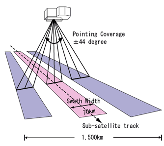
Its instantaneous field-of-view (IFOV) is the main improvement over AVNIR. AVNIR-2 also provides 10m spatial resolution images, an improvement over the 16m resolution of AVNIR in the multi-spectral region. Improved CCD detectors (AVNIR has 5,000 pixels per CCD; AVNIR-2 7,000 pixels per CCD) and electronics enable this higher resolution. A cross-track pointing function for prompt observation of disaster areas is another improvement. The pointing angle of AVNIR-2 is +44 and - 44 degree.
| Number of Bands | 4 |
|---|---|
| Wavelength | Band 1 : 0.42 to 0.50 micrometers Band 2 : 0.52 to 0.60 micrometers Band 3 : 0.61 to 0.69 micrometers Band 4 : 0.76 to 0.89 micrometers |
| Spatial Resolution | 10m (at Nadir) |
| Swath Width | 70km (at Nadir) |
| S/N | >200 |
| MTF | Band 1 through 3 : >0.25 Band 4 : >0.20 |
| Number of Detectors | 7000/band |
| Pointing Angle | - 44 to + 44 degree |
| Bit Length | 8 bits |
Note: AVNIR-2 cannot observe the areas beyond 88.4 degree north latitude and 88.5 degree south latitude.