Research & Meetings
The K&C Global Mangrove Watch
Background:
These changes can take place over decades but can also be very rapid, and updated information on their change status is therefore required on a regular basis. For countries reporting on the UN Sustainable Development Goals or participating in the REDD+ scheme, information about mangrove extents and changes over time is of critical importance.
While cloud cover limits the use of optical satellite data in tropical and sub-tropical regions, Synthetic Aperture Radar sensors are particularly well suited for mangrove monitoring as SAR data can be acquired regardless of clouds, smoke and haze. L-band SAR is particularly suitable as it is sensitive to vegetation structure and therefore has the capacity to detect changes in time-series of data. With JAXA’s JERS-1 SAR, ALOS PALSAR and ALOS-2 PALSAR-2 missions a consistent L-band SAR data record spanning over three decades is available and provides a unique opportunity to map the extents and changes of the global mangrove cover since the mid 1990s.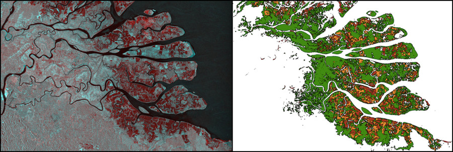
Kahan river delta, North Kalimantan, Indonesia. (a–Left) Multi- temporal SAR composite (1996 JERS-1 SAR and 2016 ALOS-2 PALSAR-2) (b–Right) Mangrove extent and changes, Red – mangroves lost 1996-2007, Orange – loss 2007-2016, Green – mangrove cover in 2016.
Aims:
The Global Mangrove Watch (GMW) was initiated as part of the JAXA K&C Initiative in 2011. It is led by Aberystwyth University (U.K.), solo Earth Observation (Japan), JAXA, Wetlands International, and the Nature Conservancy (TNC). The GMW provides geospatial information about mangrove extent and changes to the Ramsar Convention, national wetland practitioners, decision makers and NGOs.
The Global Mangrove Watch (GMW) dataset (version 3.0) provides maps of estimated global extent and changes of mangrove forests derived from for eleven annual epochs between 1996 and 2020. The GMW v3.0 mangrove maps are publicly available through JAXA EORC (raster data) and on Zenodo (vector data).
The next version of the GMW dataset, version 4, planned for release in 2025. GMW v.4 will include a new baseline map from 2020 and extent and change mas from 1985 to 2025.
References:
- Bunting P., Rosenqvist A., Hilarides L., Lucas R.M., Thomas N., Tadono T., Worthington T.A., Spalding M., Murray N.J., Rebelo L-M., Global Mangrove Extent Change 1996–2020: Global Mangrove Watch Version 3.0. Remote Sens. 2022, 14, 3657; doi.org/10.3390/rs14153657
- Bunting P., Rosenqvist A., Hilarides L., Lucas R., Thomas N., Global Mangrove Watch: Updated 2010 Mangrove Forest Extent (v2.5). Remote Sens. 2022, 14, 1034; doi.org/10.3390/rs14041034
- Bunting P., Rosenqvist A., Lucas R., Rebelo L-M., Hilarides L., Thomas N., Hardy A., Itoh T., Shimada M. and Finlayson C.M. (2018). The Global Mangrove Watch – a New 2010 Global Baseline of Mangrove Extent. Remote Sens. 2018, 10, 1669; doi:10.3390/rs10101669
- Thomas N., Bunting P., Lucas R., Hardy A., Rosenqvist A., and Fatoyinbo L. (2018) Mapping Mangrove Extent and Change: A Globally Applicable Approach . Remote Sens. 2018, 10, 1466; doi:10.3390/rs10091466
- Thomas, N., Lucas, R., Itoh, T., Simard, M., Fatoyinbo, T., Bunting, P. and Rosenqvist, A. An approach to monitoring mangrove extents through time- series comparison of JERS-1 SAR and ALOS PALSAR data. Wetlands Ecology and Management (2015) 23:3–17 doi.org/10.1007/s11273-014-9370-6
- Rosenqvist A., Lucas R., Rebelo M-L., Shimada M., et al. (2011), The K&C Global Mangrove Watch – the way forward. The 16th Kyoto & Carbon Initiative Science Team meeting, Oct. 17-21, 2011, Tokyo, Japan.
GMW Contact point
Dr. Ake Rosenqvist, GMW and K&C Science Coordinator
solo Earth Observation (soloEO)
Tokyo 104-0054, Japan
Email: aprojectjaxa.jp