


* Please refer "Product Format Descriptions" to get data descriptions. Note that these data will be revised, if necessary. (Last Update: PALSAR Nov. 8, 2005, PRISM/AVNIR-2 Sep. 7, 2005)
Polarimetric Mode, 4 Polarization (PLR)
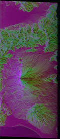
(R:G:B=HH:HV:VV)
Level 1.1
PLR_L11.zip (zip Compress/ 796MB)
Level 1.5
PLR_L15.zip (zip Compress/ 73.5MB)
PLR_L11.zip (zip Compress/ 796MB)
Level 1.5
PLR_L15.zip (zip Compress/ 73.5MB)
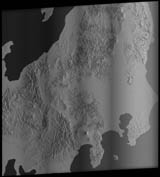
ScanSAR Mode, Single Polarization (WB1)
Level 1.0
WB1_L10.zip (zip Compress/ 622MB)
Level 1.5
WB1_L15.zip (zip Compress/ 22.4MB)
WB1_L10.zip (zip Compress/ 622MB)
Level 1.5
WB1_L15.zip (zip Compress/ 22.4MB)
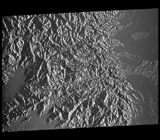
Fine Mode, Single Polarization (FBS)
Level 1.1
FBS_L11.zip (ZIP Compress/ 1.34GB)
Level 1.5
FBS_L15.zip (ZIP Compress/ 202MB)
FBS_L11.zip (ZIP Compress/ 1.34GB)
Level 1.5
FBS_L15.zip (ZIP Compress/ 202MB)
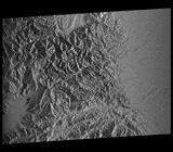
Fine Mode, Dual Polarization (FBD)
Level 1.0
FBD_L10.zip (ZIP Compress/ 456MB)
Level 1.1
FBD_L11.zip (ZIP Compress/ 1.33GB)
Level 1.5R (Geo-reference)
FBD_L15R.zip (ZIP Compress/ 107MB)
Level 1.5G (Geo-coded)
FBD_L15G.zip (ZIP Compress/ 107MB)
FBD_L10.zip (ZIP Compress/ 456MB)
Level 1.1
FBD_L11.zip (ZIP Compress/ 1.33GB)
Level 1.5R (Geo-reference)
FBD_L15R.zip (ZIP Compress/ 107MB)
Level 1.5G (Geo-coded)
FBD_L15G.zip (ZIP Compress/ 107MB)
OB1 (Forward view of triplet observing mode)

Level 1A
ALPSMF001722390-O1A____F.zip (ZIP Compress/ 35.3MB)
Level 1B1
ALPSMF001722390-O1B1___F.zip (ZIP Compress/ 34.3MB)
Level 1B2 (Geo-reference)
ALPSMF001722390-O1B2R_UF.zip (ZIP Compress/ 40.3MB)
ALPSMF001722390-O1A____F.zip (ZIP Compress/ 35.3MB)
Level 1B1
ALPSMF001722390-O1B1___F.zip (ZIP Compress/ 34.3MB)
Level 1B2 (Geo-reference)
ALPSMF001722390-O1B2R_UF.zip (ZIP Compress/ 40.3MB)
OB2 (Nadir view (70km) of Nadir + Backward observing mode)

Level 1A
ALPSMW012594720-O1A____W.zip (ZIP Compress/ 97.7MB)
Level 1B1
ALPSMW012594720-O1B1___W.zip (ZIP Compress/ 98.7MB)
Level 1B2 (Geo-reference)
ALPSMW012594720-O1B2R_UW.zip (ZIP Compress/ 102MB)
ALPSMW012594720-O1A____W.zip (ZIP Compress/ 97.7MB)
Level 1B1
ALPSMW012594720-O1B1___W.zip (ZIP Compress/ 98.7MB)
Level 1B2 (Geo-reference)
ALPSMW012594720-O1B2R_UW.zip (ZIP Compress/ 102MB)

Level 1A
ALAV2A012586980-O1A____.zip (ZIP Compress/ 70.9MB)
Level 1B1
ALAV2A012586980-O1B1___.zip (ZIP Compress/ 68.7MB)
Level 1B2 (Geo-reference)
ALAV2A012586980-O1B2R_U.zip (ZIP Compress/ 53.0MB)
ALAV2A012586980-O1A____.zip (ZIP Compress/ 70.9MB)
Level 1B1
ALAV2A012586980-O1B1___.zip (ZIP Compress/ 68.7MB)
Level 1B2 (Geo-reference)
ALAV2A012586980-O1B2R_U.zip (ZIP Compress/ 53.0MB)