Fishery
Satellite remote sensing data have been used effectively in various fishery fields in recent years. Sea surface temperature (SST) observation by infrared sensors is the most popular example. Infrared sensors, however, cannot observe the sea surface when it is covered with clouds. Consequently, in cloudy regions and seasons, they cannot provide useful SST data continuously without gaps. Such is the case of the sea of Japan in wintertime. Since microwave remote sensing of SST is not affected by clouds, it is expected to be used in fishery applications more extensively in the future.
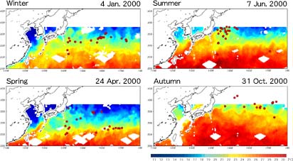
| Daily Mean Sea Surface Temperature Field Estimated by TMI and Superimposed Positions of Fishing Grounds for Each Season. |
|
 |
|
These four figures show the positions of fishing grounds (red circles) superimposed on the sea surface temperature field in each season. The target fishes of long-line fishing are albacore, big eye tuna, and yellow fin tuna, which are the most important fishes for Japanese fisheries. Since each kind of fish has an optimum temperature range, fishing grounds tend to center on an area of similar temperature. Concentrations of fishing grounds are clearly separated into different temperature areas due to differences in targeted fish. Fishing grounds are also found to build up at warm fronts and boundaries of temperature changes. If we can estimate sea surface temperature from satellite data, we will be able to determine possible fishing grounds and catch fish efficiently. We expect that ocean satellite remote sensing will contribute to protecting and controlling fish resources, and thus play an important role in fishery. Data of fishing grounds provided by Mr. Katsuya Saitoh, Japan Fisheries Information Service Center. |