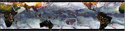
TRMM Microwave Imager (TMI) 2-day (DEC. 7&8) composite. Image is a 3-channel combination to highlight cold temperatures (bright yellow) found in many tropical storms. White rectangle identifies Cyclone Pam.
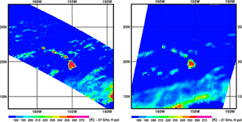
Comparison of TMI and SSM/I (Hawaii) Dec. 2, 1997(UTC)
TMI SSM/I
Simultaneous image of TRMM Microwave Imager (TMI) and Special Sensor Microwave/imager (SSM/I). The greater spatial resolution of TMI allow higher quality rainfall estimates to be made.
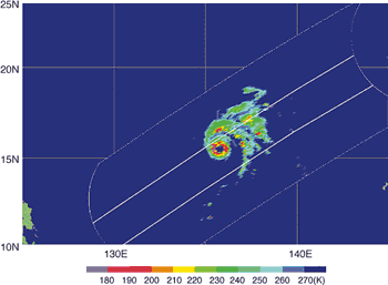
Typhoon No. 28 observed by 85 GHz vertical brightness Temperature (PAKA)
Dec. 19, 1997 the Philippine coast
Figure shows the image of the Super Typhoon PAKA observed by TMI. This image shows the 85GHz, vertically polarized brightness temperature. The temperature is lower in the rain regions because of microwave scattering by ice crystals and rain drops. The rain area from PR corresponded with that from TMI.