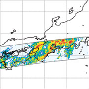
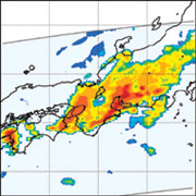
These figures show heavy rain over Tokai area observed by Precipitation Radar (PR) and TRMM Microwave Imager (TMI) on Sep. 11, 2000 18:25 (UTC).
Horizontal rainfall observed by PR (left) and TMI (right) at 18UTC 11 September 2000. Strong rainfall regions (red to yellow) observed around Tokai area. Also, TMI has wider swath than PR, and can estimate rainfall over a vast area of Japanese Islands.
Over 30 thousand houses around Nagoya were flooded due to collapsed of river embankments.