SGLI Standard data (JASMES format) are stored in netCDF4 files whish are generated by resampling the SGLI standard data in HDF5 files onto the JASMES-Grid.
Scheduled to update
・Global LTOA(8-day, monthly) data are reprocessing 2018-2021(Product:LV01-11, LS01-04, LT01-02, LI01-02, LGEI, LGEV, LGEP). We will announce after creation.For detail, please refer to here.(2022/12/5)
・Some incorrect values are stored in the xx_STD data set stored in the Global statistics products.We plan to reprocess and publish it. As soon as the reprocessing is completed, we will announce and the data will be replaced.(2022/12/5)
Data updates
| 2023/06/20 |
We released JASMES Global/Japan AROT products which are reprocessed for a bug of SGLI standards products. By the reprocessing, snow contamination due to the bug is improved. For details of the reprocessing, please refer to here. |
| 2023/03/16 |
・Global CLFG(Daily) have been published on JASMES SGLI Standard monitor. ・Added the Polar Stereo (North/South) to the target area. Term : Daily, 8-day, monthly Product : LST, NDVI, SST, AROT, SICE, SIST |
| 2023/01/06 |
The climatological data/anomaly images of AROT and the JASMES aerosol statistical product have been published on JASMES SGLI Standard monitor. For detail of the new product, please refer to here. For details of the anomaly image, please refer to here. (2023/01/06) |
| 2022/12/08 | ・Japan Daily SICE data(2021/6-7) was reprocessed. |
| 2022/12/05 |
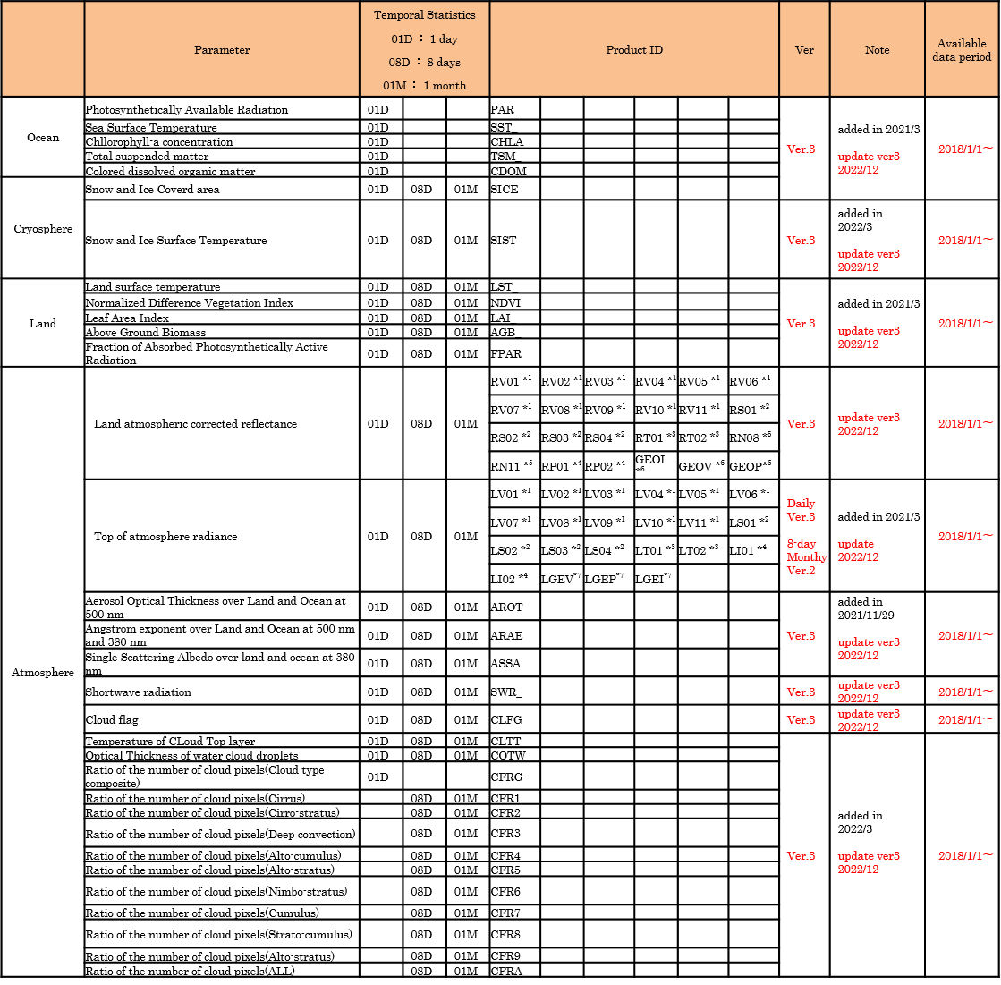
・All JASMES SGLI Standard products has been updated to ver.3. ・Statics products for Ocean around Japan(8-day,monthly) were released(SST、PAR、CHLA、TSM、CDOM). For detail, please refer to here. ・Anomaly Image were released(LST、NDVI、CHLA、SST、SWR、AROT).For detail, please refer to here. AROT climatic anomaly images are under construction. We will announce after creation. |
Restriction
・The latutude and longitude of the netCDF data are stored in Float32. Please check Area and resolution when using.
・For 8-day and monthly, input data may be less when the minor version is switched.
・AROT(8-day,monthly) is different for global product and Polar Stereo product.
Data to use when creating, Global:proprietary Aerosol statistical product of JASMES SGLI Standard product monitor, Polar Stereo:Standard Product.
Area and resolution
| Area | pixel size | Latitude and Longitude (pixel center value) |
|---|---|---|
| Global | 0.05deg | Upper left Lon:0.0deg.E, Lat:90.0deg.N |
| Lower right Lon:359.95deg.E (-0.05deg.W), Lat:90.0deg.S | ||
| Japan | 0.0025deg | Upper left Lon:123.00125deg.E, Lat:49.99875deg.N |
| Lower right Lon:149.99875deg.E, Lat:24.00125deg.N |
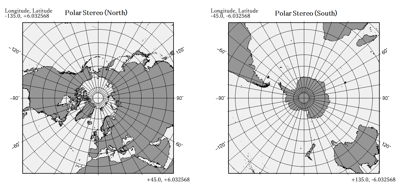
Polar Stereo (North/South) is as follows. Latitude and longitude information for each pixel is stored in netCDF.
JASMES SGLI Standard data Granule ID
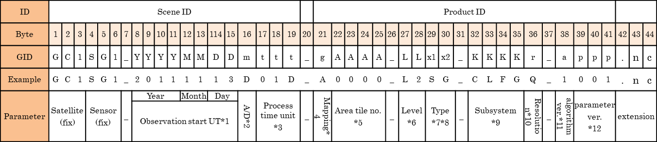
JASMES SGLI Standard data Granule ID Setting Value

Monthly climatological data for anomary images
For details of climatological data, please refer to below.
・SGLI climatology data (LST_, NDVI, SST_, CHLA, SWR_)
・SGLI climatology data (AROT)
File name
・Global:
GC1SG1_YYYYMM00D01M_D0000_3MSG_KKKKM_CLIM.nc
・Japan:
GC1SG1_YYYYMM00D01M_D0000_L2SG_KKKKQ_CLIM.nc
   * MM    : Target Month
   * KKKK  : Product ID(LST_, NDVI, SST_, CHLA, SWR_, AROT)
Only for AROT, Japan data is named as follows.
GC1SG1_YYYYMM00D01M_J0000_3MSG_AROTQ_CLIM.nc
* MM : Target Month
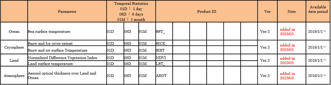
JASMES SGLI Standard data (Japan) Product ID
JASMES SGLI Standard data (Global) Product ID
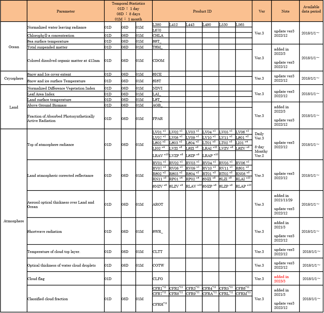
          *1 Vxx : VNR-NP Band xx
          *2 Sxx : IRS-SWIR Band xx
          *3 Txx : IRS-TIR Band xx
          *4 Pxx : VNR-PL Band xx
          *5 Nxx : Reflectance of VNR-NP Band xx co-registered for VNR-PL
          *6 GEO : Geometry(V:VNR-NP, I:IRS, P:VNR-PL)
          *7 LGE : Geometry(V:VNR-NP, I:IRS, P:VNR-PL)
          *8 LVZ or SNZ : Sensor Zenith Angle (V:VNR-NP, I:IRS, P:VNR-PL)
          *9 LSZ or SLZ : Solar Zenith Angle (V:VNR-NP, I:IRS, P:VNR-PL)
          *10 LRA or RLA : Relative Azimuth Angle (V:VNR-NP, I:IRS, P:VNR-PL)
          *11 CFR : Cloud type(1: Crrus, 2: Cirro-stratus, 3: Deep convection, 4: Alto-cumulus, 5: Alto-stratus,
                     6: Nimbo-stratus, 7: Cumulus, 8: Strato-cumulus, 9: Stratus, A: ALL,
                     H: Hight, M: Middle, L: Low )
JASMES SGLI Standard data Polar Stereo (North/South) Product ID