Satellites and Observation Sensors
  • Top
  • Technical development
  • Satellites and Observation Sensors
  • Synergistic observation by 4 instruments

Synergistic observation by 4 instruments

The EarthCARE has four different types of instruments (radar, lidar, imager, and radiometer) and the synergy products that combine more than two instruments’ data are produced. The "synergetic observation", in which the four instruments observe same targets in almost identical location and time, allows the harmony of these instruments.

Observation method of each sensor

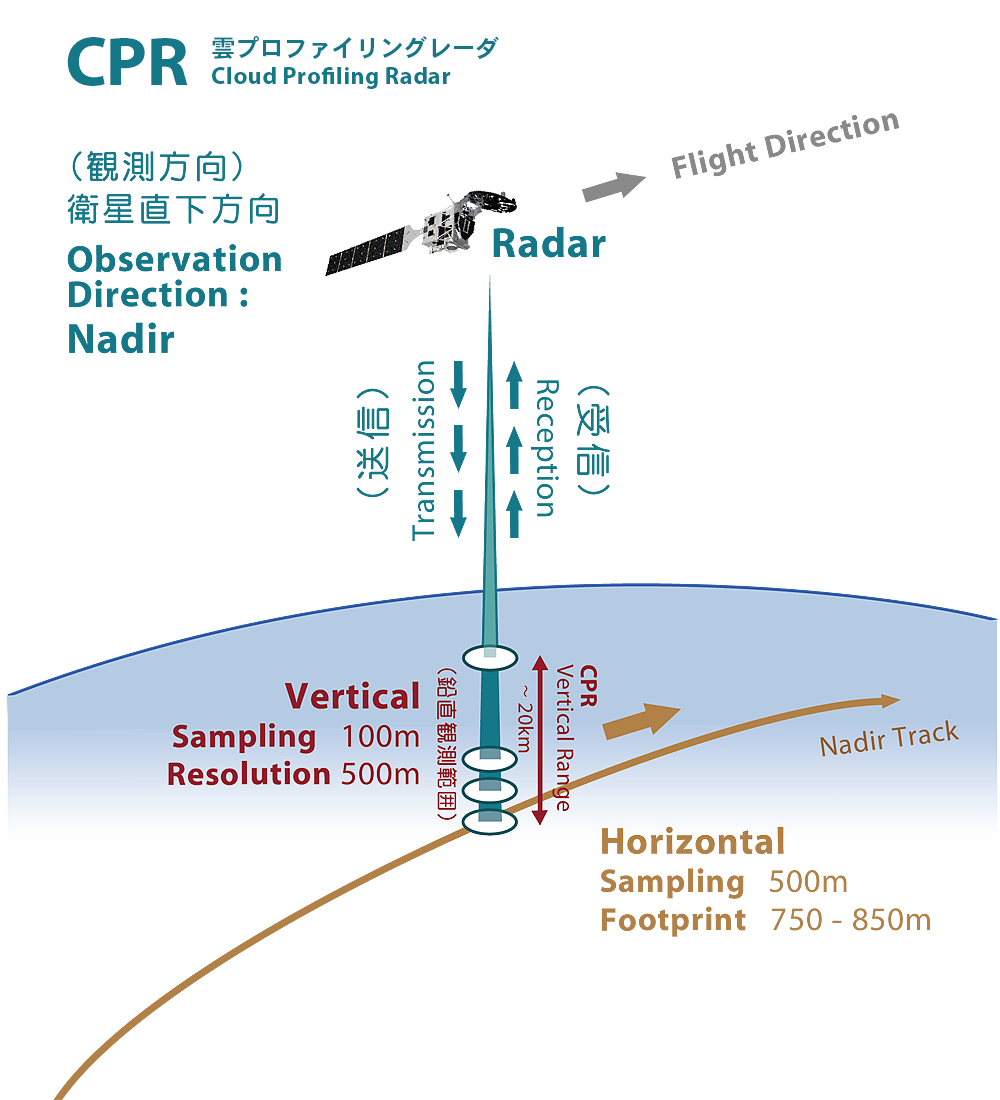
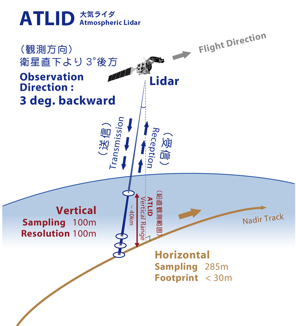
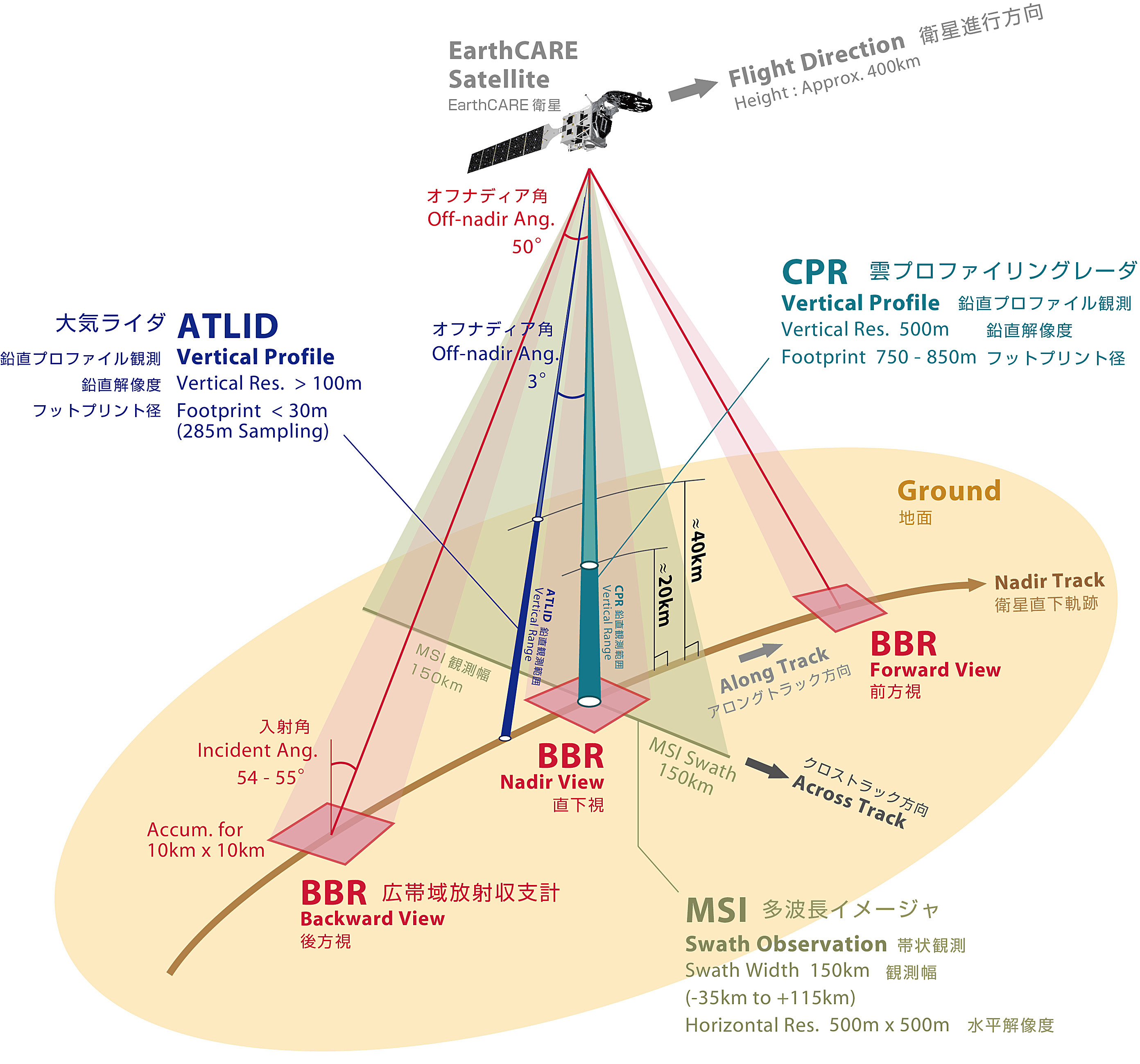
CPR and ATLID are active sensors that detect targets by transmitting signals toward the Earth's surface (including clouds and aerosols), and detect information according to the distance in the line-of-sight direction (direction of signal transmission: generally vertical). CPR acquires vertical distribution data from the ground to an altitude of up to 20 km, while ATLID acquires vertical distribution data from the ground to up to 40 km.

The CPR's line of sight is directly below the satellite, while the line of sight of ATLID is 3 degrees behind the satellite, the corresponding difference of distance is about 20 km near the surface, or about 3 seconds in time. This difference is almost negligible from the perspective of understanding cloud and aerosol dynamics by satellite.

MSI and BBR are passive sensors that detect objects by receiving electromagnetic waves reflected or emitted from the Earth's surface into space. MSI detects an area approximately 150 km wide in the cross-track direction, while BBR detects an area of 10 km square in each of the three directions (forward, nadir, and backward).

Sensor CPR (Cloud Profiling Radar) ATLID (Atmospheric Lidar) MSI (Multi-Spectral Imager) BBR (Broad-Band Radiometer)
Sensor type Active Active Passive Passive
Sensor type Radar (Doppler radar) Lidar (high spectral resolution lidar) Visible infrared radiometer (push-bloom imaging scanner) Broadband radiometer
Frequency / Observation band W band (94 GHz) Ultraviolet (355 nm) Visible to thermal infrared (7 bands) Short wave and long wave
Observation Direction Nadir 3 deg. backward Nadir + Swath (115 km left of nadir, 35 km right of nadir) 3 direction pointing (Forward / Nadir / Backward)
Maximum observation range Ground to altitude 20 km Ground to altitude 40 km Horizontal 150 km width 10 km x 10 km
Footprint (IFOV) 750 to 850 m < 32 m Approx. 500 m 10 km x 10 km
Sampling Horizontal approx. 100 m
Vertical approx. 100 m
Horizontal approx. 280 m (target 140 m)
Vertical approx. 100 m
Horizontal Approx. 500 m Horizontal Approx. 1 km
Main observation targets Cloud particles, drizzle, raindrops, vertical wind Aerosols, thin cloud particles Clouds, aerosols Radiation energy