Validation
  • Top
  • Calibration & Validation
  • Validation

Three objectives of EarthCARE and product validation

EarthCARE aims to

  1. Enhance scientific understanding of climate change mechanisms related to clouds and aerosols through the analysis of EarthCARE observation data,
  2. Support climate adaptation strategies by incorporating these mechanisms into climate models,
  3. Facilitate operational applications in numerical weather prediction and atmospheric environmental monitoring through reliable EarthCARE products.

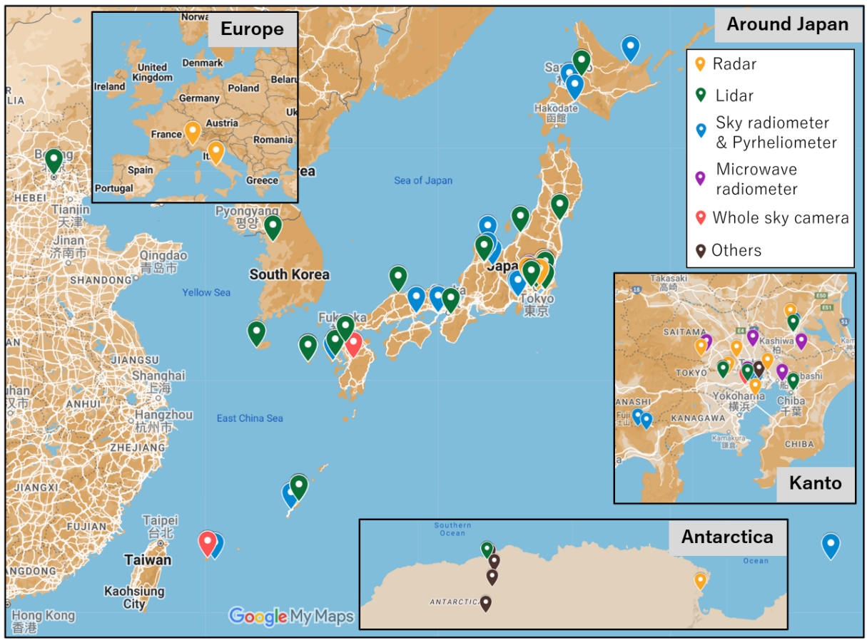
Through product validation activities, we aim to lay the foundation for achieving these objectives by providing EarthCARE products with assured quality and reliability. JAXA have formulated a product validation plan and have been advancing validation activities since the launch of the EarthCARE satellite in May 2024.

Validation plan overview

The EarthCARE JAXA Level 2 (L2) products are categorized into two types: L2a products, derived from a single sensor, and L2b products, created through synergistic use of multiple sensors. L2a products and CPR-ATLID synergistic L2b products are scheduled for release nine months after launch (March 2025), while other L2b products will be released 18 months after launch. Validation results will also be published alongside the products as quality information.

Validation activities are conducted by the JAXA EarthCARE Validation Team, consisting of experts from universities and research institutions, primarily Principal Investigators (PIs) of JAXA’s Research Announcement on the Earth Observations. International collaboration is a cornerstone of the EarthCARE validation activity, involving a key partnership with the European Space Agency (ESA) for sharing validation-related information, promoting exchanges between European and Japanese researchers through the jointly organized international workshops. We also corporate with the Deutsches Zentrum für Luft- und Raumfahrt (DLR), and the U.S. National Oceanic and Atmospheric Administration (NOAA) for sharing ground-based and aircraft campaign dataset as well as scientific expertise to support robust validation.

Correlative data for validation

The validation employs diverse datasets, including ground-based network observations, satellite data, and aircraft campaigns. Main correlative data for JAXA EarthCARE standard product is summarized in Table 1. Figure 1 shows the geolocation of ground-based observation for validation. For early validation, emphasis is placed on sample size, leveraging satellite and ground-based network observations. Additionally, intensive validation efforts are being conducted using specialized instruments, such as radars, lidars and other instruments installed at the NICT headquarters in Koganei, Japan.

Table 1 Correlative data for each JAXA EarthCARE standard product
Product name Main parameters Correlative data
CPR One-sensor
Echo Product
Integrated radar reflectivity factor, integrated doppler velocity NICT Koganei composite observation, WINDAS, NIED Ka-band radars, CloudSat (climatology), DLR HALO
CPR One-sensor
CPR-ATLID Synergy
CPR-ATLID-MSI Synergy
Cloud Product
Cloud mask, cloud particle type, liquid water content, ice water content, effective radius of liquid/ice water cloud, and optical thickness, liquid water path, ice water path NICT Koganei composite observation, NIED Ka-band radars, A-Train (climatology), DLR HALO, Microwave radiometer
ATLID One-sensor
Cloud and Aerosol Product
Feature mask, target mask, extinction coefficient, backscatter coefficient, lidar ratio, depolarization ratio, and planetary boundary layer height AD-Net, SAVERNET, SKYNET, AERONET, CALIPSO (climatology), Aeolus
MSI One-sensor
Cloud Product
Cloud flag, cloud phase, optical thickness, effective radius, cloud top temperature, cloud top pressure, and cloud top height All-sky camera, GCOM-C, Himawari, BSRN, Sky radiometer, Microwave radiometer
Four Sensors Synergy Radiation Budget Product SW/LW radiative flux and SW/LW radiative heating rate BSRN, GEBA, CERES, BBR, A-Train (climatology)

Geolocations of ground-based instruments for validation
Fig. 1 Geolocations of ground-based instruments for validation