Multi-Spectral Imager (MSI)
  • Top
  • Technical development
  • Satellites and Observation Sensors
  • Multi-Spectral Imager (MSI)

The Multi-Spectral Imager (MSI) is a passive sensor with seven sensitivity channels in the visible to thermal infrared regions. It measures electromagnetic waves emitted and reflected from the Earth's surface including the atmosphere. The data from each channel provides information on the properties and distribution of clouds and aerosols.

MSI is the only sensor onboard EarthCARE with a cross-track range (perpendicular to the satellite's direction of travel), which means that it can acquire data over an area of approximately 150 km in width near the Earth's surface. Unlike vertical profiles from radar or lidar observation, MSI data offers horizontal information that includes the atmosphere on the Earth’s surface. Such planar information from MSI complements the vertical information from CPR and ATLID in the horizontal direction and enhances the effectiveness of the synergetic data from the four integrated sensors as three-dimensional information.

MSI

MSI's seven channels consist of four channels (visible, near-infrared, and short-wavelength infrared) that measure the reflection of sunlight by the Earth and three channels (thermal infrared) that measure Earth radiation. Nighttime observation data are obtained from only three thermal infrared bands.

In order to avoid the influence of sunglint (specular reflection of the sun) caused by the sea surface during the daytime, the observation width is designed to be asymmetric around the nadir of the satellite, covering about 115 km east of the satellite and about 35 km west during daytime decent.

MSI Observation Targets

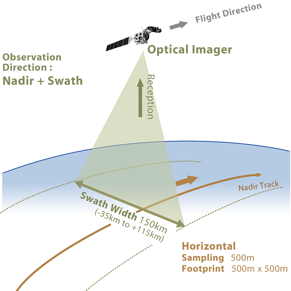
MSI observations provide data on the amount of radiation (radiance or radiance temperature) from the Earth's surface and atmosphere for each channel. Based on these data, level 2 processing is performed to calculate parameters related to the distribution and physical properties of clouds and aerosols, such as the cloud flag, cloud phase, cloud optical thickness, cloud effective particle radius (1.6 μm, 2.2 μm), cloud top temperature and height, and cloud top pressure. The calculation of parameters related to the physical properties of ice clouds and the optical properties of aerosols are provided for research and development purposes only.

MSI Data Products

MSI observation data will be provided as L1b (ESA generated) and L2a products. In addition, data related to the retrieval of clouds and aerosols and data related to the radiation budget are provided as L2b products when combined with observation information from other sensors.

MSI Standard Products:
MSI Research Products:
Main Observation Parameters of MSI (Design Requirements)
Sensor type Multi-Spectral Imager (Pushbroom scanner)
Developer European Space Agency (ESA)
Swath 150 km
(Left side of the travel direction: 115 km, Right side of the travel direction: 35 km)
Channel center wavelength VIS 0.67 μm
NIR 0.865 μm
SWIR 1.65 μm
2.21 μm
TIR 8.80 μm
10.80 μm
12.00 μm
Footprint (IFOV) 500 m
Sampling 500 m
MSI channel settings and radiometric properties (design requirements)
Channel Channel center wavelength Bandwidth(50%) Dynamic range S/N
(@ albedo=1.0)
NEdT
(@ 293K, 200K)
VIS 0.67 μm 0.02 μm 0-110% 500 -
NIR 0.865 μm 0.02 μm 0-110% 500 -
SWIR 1.65 μm 0.05 μm 0-112% 250 -
2.21 μm 0.1 μm 0-110% 250 -
TIR 8.80 μm 0.9 μm 170-350 K - 0.25K, 0.8 K
10.80 μm 0.9 μm 170-350 K - 0.25K, 0.8 K
12.00 μm 0.9 μm 170-350 K - 0.25K, 0.8 K