Satellites and Observation Sensors
  • Top
  • Technical development
  • Satellites and Observation Sensors
  • Atmospheric Lidar (ATLID)

Atmospheric Lidar (ATLID)

Atmospheric Lidar (ATLID) is an active sensor that transmits a 355 nm (ultraviolet) laser beam and receives the backscatter from clouds, aerosols, and atmospheric molecules.

Lidar, also called laser radar, is based on radar principles but uses visible and ultraviolet light, which have even shorter wavelengths than microwaves. It is sensitive to particles, such as aerosols and atmospheric molecules. Like radar, it can also measure the line-of-sight distance to an object from the time shift of the received signal. To avoid the effects of specular reflection from cirrus clouds and sea surfaces, ATLID transmits signals approximately 3 degrees behind the nadir of the satellite. Thus, an altitude profile of the backscatter intensity in this line of sight can be obtained.
The ATLID signal is horizontally polarized, and the receiver measures the returned polarization, which provides information on the shape of the particles.

ATLID

Lidar’s transmitted wave is a small beam-spread laser for highly directional observation. Thus, the instantaneous field of view (i.e., the ground footprint) is very small.
ATLID is also known as High Spectral Resolution Lidar (HSRL), which transmits a laser with a very narrow spectral bandwidth and receives a backscattered signal that is a composite of Mie scattering (narrow spectral bandwidth) by aerosols and clouds and Rayleigh scattering (broad spectral bandwidth) by atmospheric molecules. The results are filtered to produce a high-resolution spectrum. This technique separates the Mie scattering by aerosols and clouds from the Rayleigh scattering by atmospheric molecules and determines the Rayleigh scattering component. This technique can independently determine the backscattering and dissipation coefficients of clouds and aerosols, which are unknowns in the lidar equation.
CALIOP on the CALIPSO satellite is a satellite-borne lidar that had been operated since 2006. ATLID uses highly spectrally resolved lidar to classify aerosols by their optical properties and to estimate their optical thicknesses more accurately.

What ATLID observes

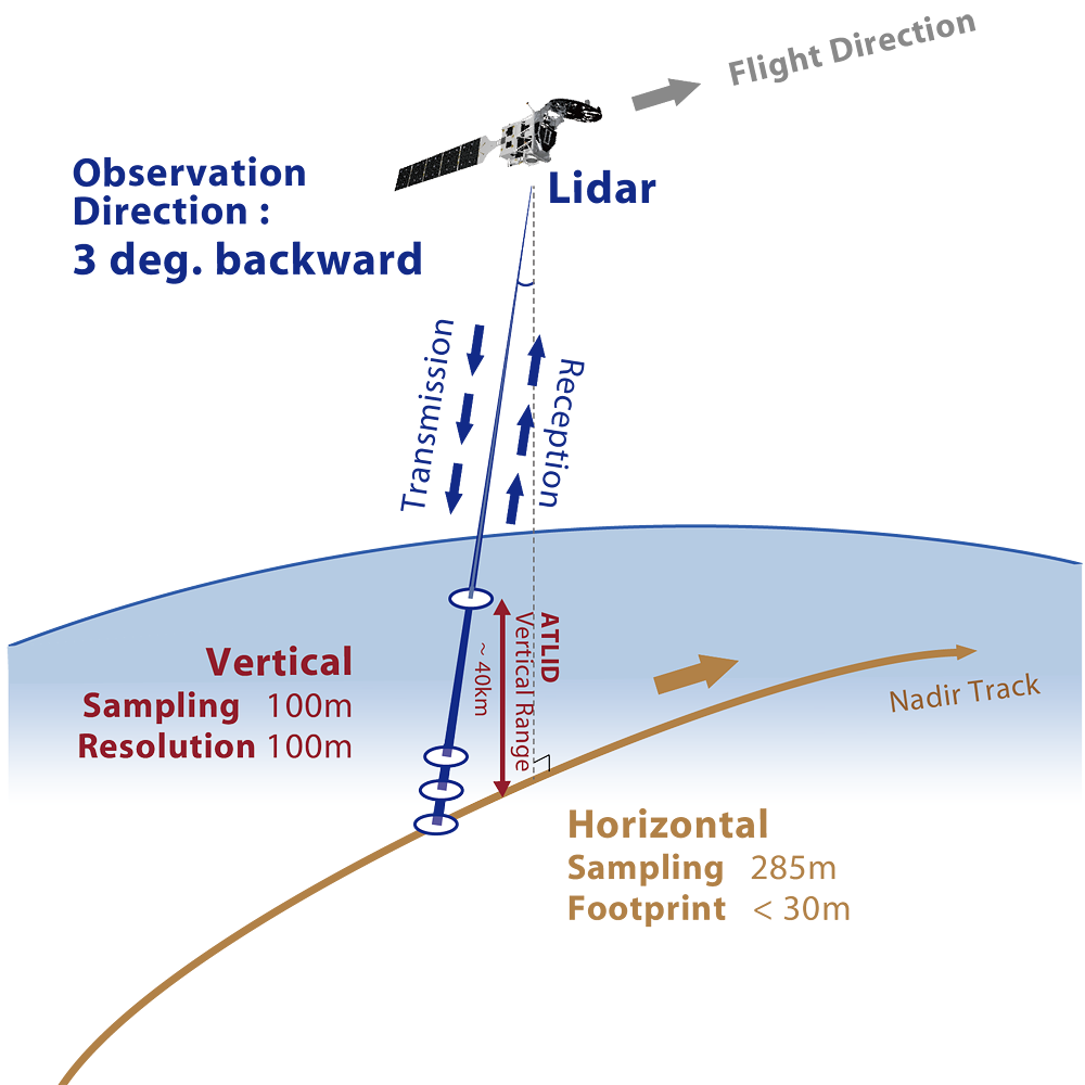
ATLID directly measures the backscatter signal, a composite of Rayleigh and Mie scattering, as an altitude profile in the atmosphere depending on the line-of-sight distance. The backscatter signal can be separated into Rayleigh and Mie scattering information by a high spectral filter, and the Mie scattering can be further separated into horizontally and vertically polarized waves. Level 1 processing takes care of these parts, resulting in a vertical profile of backscatter intensity data in three channels: Rayleigh, Mie (horizontal polarization), and Mie (vertical polarization*1).
Level 2 processing is then used to detect aerosols and clouds, classify cloud particle phases and shapes and aerosol types, and derive dissipation coefficients, backscatter coefficients, lidar ratios, polarization resolution, and atmospheric boundary layer height for aerosols and clouds.

*1Also called cross-polarization.

ATLID Data Products

ATLID observation data are provided as “L1b” (created by ESA) for received signal intensity and as “L2a” products for physical quantities such as the above. In the L2a product, the detection of aerosols and clouds is called the feature mask, and the classification of cloud particle phase, shape, and aerosol type is called the target mask.
When combined with ATLID and CPR observations, the CPR-ATLID synergistic L2b product provides data on cloud and aerosol distribution and physical properties complemented by radar and lidar, and the CPR-ATLID-MSI synergistic L2b product includes MSI observations. Others are also provided.

ATLID standard products :
ATLID research products :
ATLID main observation parameters (design requirements)
Sensor type High Spectral Resolution Lidar (HSRL)
Developer European Space Agency (ESA)
Center wavelength 355 nm
Measurement range Ground to 40 km
Footprint (IFOV) < 32 m
Horizontal sampling Approx. 280 m
(Target 140 m)
Vertical sampling Approx. 100 m