Cloud Profiling Radar Development
- Top
- Developing Technologies
- Cloud Profiling Radar Development
Cloud Profiling Radar (CPR) Development
JAXA has developed the Cloud Profiling Rader (CPR) onboard the EarthCARE satellite in cooperation with the National Institute of Information and Communications Technology (NICT) to evaluate the interaction between clouds and aerosols because the clouds simulated by current climate models has discrepancies compared with reality.
CPR is a measurement device that determines the vertical structure of clouds. By transmitting radar radio waves toward the Earth from a satellite orbiting in space and evaluating the bounced-back radio waves, it is possible to analyze the cloud structure of the entire Earth in detail. In addition, CPR measures the speed of cloud particles ascent and descent, the first time in the world as a spaceborne radar. Measuring the vertical motion of clouds at about one meter per second from a satellite moving at about seven kilometers per second is a very challenging.
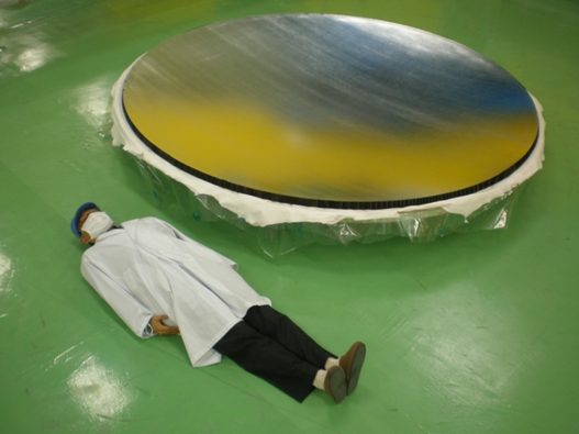
CPR antenna with a large diameter of 2.5 meters and a highly accurate surface (within 60 μm). This antenna is the largest such onboard satellite sensor in the world.
Observation of cloud vertical structure
The clouds we see daily are composed of particles ranging in size from a few to several tens of microns. They occur between the ground and altitudes of more than 10 kilometers.
At relatively low altitudes, water clouds a collection of water grains, but at higher altitudes, they are ice clouds, composed of ice grains.
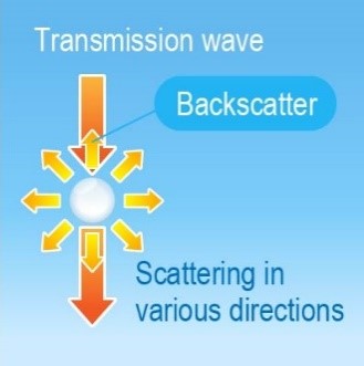
JAXA and NICT are jointly developing the Cloud Profiling Radar (CPR) to observe such clouds. CPR observes the vertical structure of clouds by emitting radio waves from space toward the earth and measuring the strength and time of the radio waves that are scattered back from the clouds (backscatter), as shown in the figure below.

There are many different types of clouds, but they are all composed of microscopic droplets of water or ice crystals.
Play the animation
How CPR observation works
When cloud particles are present, most of the CPR transmission is scattered in all directions. The radio waves reflected toward the antenna are called backscatter, which CPR receives as observation data. The strength of the backscatter provides information on the nature of the cloud. The time to the reception of the backscatter can be obtained, and the distance between the CPR and the cloud (i.e., the height of the cloud) determined.
CPR uses radio waves with a wavelength of approximately 3 mm, about one-tenth that of conventional rainfall radar. To observe various types of clouds, from thick to thin, with high sensitivity, CPR will be equipped with an antenna 2.5 meters in diameter, one of the world’s largest millimeter-wave antennas for onboard satellites.
The upper right figure is an overview of observations made by CPR.
CPR observes only toward the nadir, as shown in the figure. The vertical (height) resolution (range of discrimination) is 500 m, but data are acquired at 100 m intervals. The CPR is designed so that the upper limit of the observation altitude can be changed according to the region (latitude). For example, in tropical regions with many high clouds, the CPR observes up to 20 km altitude, but in high latitude regions without tall clouds, the CPR observes up to 16 km altitude.
The resolution (footprint) on the Earth’s surface is less than 800 meters. In actual operation, data are acquired approximately every 500 meters along the satellite’s track by firing a series of pulsed radio waves one after another as the satellite progresses in its orbit.
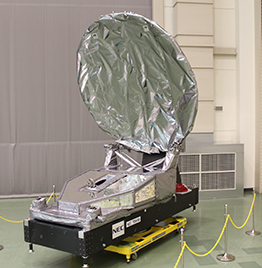
Appearance of CPR

In addition to observing the vertical structure of clouds, CPR has another important feature. CPR is the world’s first spaceborne radar using the Doppler effect to capture the motion of cloud particles in clouds. Since the motion in clouds, especially upwelling, is related to the formation of cloud particles, the information obtained by Doppler radar will contribute greatly to understanding the cloud formation process, which is the goal of EarthCARE. In addition, when clouds begin to rain, the velocity of fall increases from one meter per second to several meters per second, making it possible to distinguish between clouds and rain through Doppler observation.