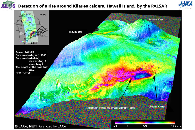
This image shows the amount of diastrophism around Kilauea caldera, Hawaii Island, in a three-dimensional manner by the PALSAR's differential interferometoric processing.
(Click to View Enlarged Image)
According to the "differential interferometric processing" (*) of observation images acquired by the PALSAR onboard the "Daichi" on the south part of Hawaii Island, Hawaii, USA, the five-meter diameter area around the south-west part of the Kilauea volcanic crater rose about 10 cm in three months between May 2 and Aug. 2, 2006, because of the expansion of a magma reservoir.
In the image on the above, the amount of diastrophism is shown in colors. Warm colors show a decrease in the distance between the satellite and the land (rise of land), and cold colors indicate the increase of the distance (subsided land). The caldera area rose by about 10 cm.
GPS receivers are installed around Mount Kilauea, which is an active volcano, and information that supports the rising magma has been acquired over last few months. The observation data by the satellite explained the situation in a two-dimension manner.

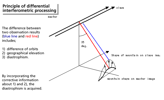
(*) Differential interferometric processing is a technology to extract (interformetrically process) diastrophism (the movement of the earthfs crust) by calculating the difference of SRA images observed and acquired from two almost similar orbits and incorporating corrective information such as elevation of the land and distance between the two orbits. (See the upper figure)
Differential interferometric processing is sensitive to the length of radio frequencies; therefore, it is reported that L-band, whose RF length is longer than that of conventionally used frequencies for SAR, is more suitable for interferometric processing. The observation again proved the excellent performance of the PALSAR, which uses an L-band 23.6 cm in length. This method will be used for detailed disaster analysis in the future.
Reference website: U.S. Geological Survey, Hawaiian Volcano Observatory
©JAXA EORC