©METI, JAXA
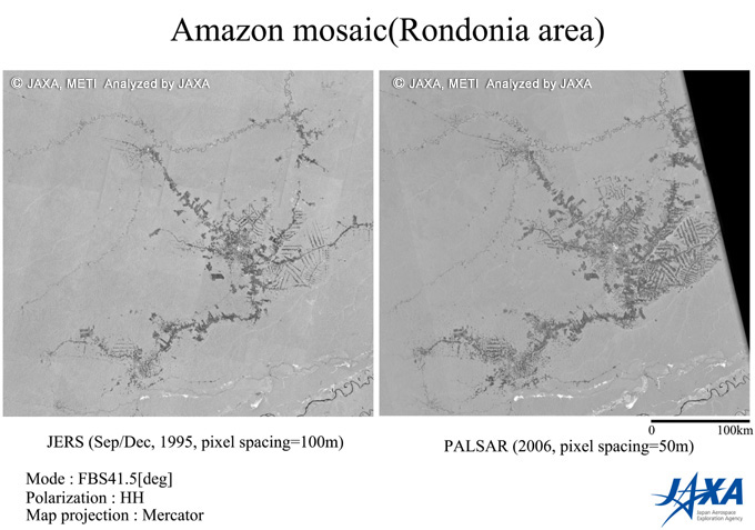
Figure1: Deforestation at the West Rondonia during eleven years.
Left is the JERS-1 SAR mosaic in 1995, right is the PALSAR mosaic in 2006.
(Click to View Enlarged Image)
©METI, JAXA
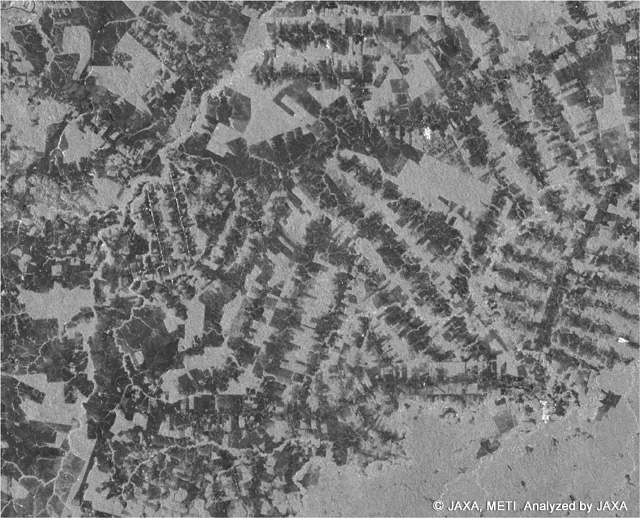
Figure 2: Enlarged PALSAR image for 70 km x 70km
Rondonia in Brazil is famous for the deforestation. It is reported that 415,000km2, total deforested area in 1990, increased to 587,000km2 in 2000, and the total loss of the forest during 10 years is equal to twice of Portugal or Uruguay*. It is also reported that the deforested area is proportional to the total cattle numbers and the extending deforestation is due to the Brazilian beef export and foreign currency acquisition. Clear-cut of the forest decreases the source of the CO2 sink and worsen the earth environment. Thus the forest monitoring is very important. It was well known that the clear-cut area can be detected from the L band radar image. Radar image of the forest area looks medium bright, whose NRCSiNormalized radar cross section, a parameter to express the brightness of the target) is -7 dB, and deforested area becomes dark as -15 dB of NRCS. Extraction of area darker than -15 dB becomes the deforestation area. Recent report of the EORC dealt with the 10 years deforestation of the Amazon. This time, we can report the large-scale deforestation found at the west Rondonia in Brazil. Figure 1 right is the PALSAR mosaic observed from May 16 to August 4 2006, while Figure 1 left is the JERS-1 SAR mosaic observed in 1995. Almost the same area was extracted. The scale of the both image is 400km in horizontal direction. Here, the dark area is the deforested and gray area is the forested area. When compared both, deforestation was in progress in this eleven years. The enlarged image in Figure 2 shows the details of the area as seen as the small fish bones.
* David Kaimowitz, Benoit Mertens, Sven Wunder and Pablo Pacheco, "Hamburger Connection Fuels Amazon Destruction1 - Cattle ranching and deforestation in Brazil's Amazon," CENTER FOR INTERNATIONAL FORESTRY RESEARCH
©JAXA EORC