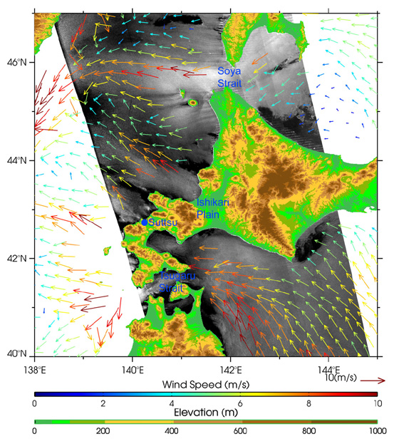
Gap winds around Hokkaido, Japan, observed by PALSAR (ScanSAR) on 8 June 2006.
(Click to View Enlarged Image)
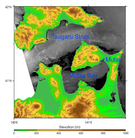
Zoomed image around Tsugaru Straits and Mutsu Bay.
(Click to View Enlarged Image)
Fig.1 shows ALOS/PALSAR ScanSAR data acquired on 8 June 2006 around Hokkaido, Japan, on which land elevation and Seawinds/QuikSCAT-observed wind vectors are superimposed. A trend dependent on an incidence angle has been removed from the PALSAR image.
Backscatter from the ocean increases approximately with wind speeds. The image shows strong backscatter (brighter) areas downstream behind Soya Strait, the Ishikari Plain, Suttsu, and Tsugaru Strait, which correspond to the QuikSCAT-measured wind pattern. These represent orographically-developed low-level jets (gap winds) over the ocean. In particular, strong winds at Suttsu are common phenomena known as "Suttsu-Dashikaze". Fig.2 is a zoomed image around Tsugaru Straits and Mutsu Bay. Strong winds blow from lowland around Mutsu, developing a wind jet over Mutsu Bay. Thus, PALSAR can detect the wind fields near the coasts, where QuikSCAT can not.
This wind pattern is a typical response to the Yamase's easterly wind, which brings about cooling summer damage in Tohoku and Hokkaido. The influence of the low-level jets on sea surface temperatures has been recently reported. By evaluating an empirical relationship between truth winds and PALSAR data, we can estimate coastal wind speed fields from PALSAR in the future.
© METI, JAXA
Copyright©1997- JAXA EORC All rights reserved.