The Ariake Sea is known as an inland sea which the tidal level moves about 7m at the spring tide and it makes vast tidal flats.
The Ariake Sea is also famous for the Nori cultivation using the big ebb and flow.
We introduce the ocean-color of the Ariake Sea in 2006 autumn observed by AVNIR-2 on ALOS.
Fig. 1 shows the RGB (true color) images by AVNIR-2.
Distribution of suspended matter in the northern Ariake Sea (seen by light blue) changed each day.
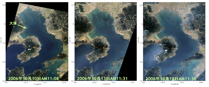
Fig.1. RGB images of the Ariake Sea on Oct. 10, 13 and 18 in 2006 by AVNIR-2
(Click to View Enlarged Image)
With the earth rotation, the tide repeats ebb tide and high tide twice per day. The sea level difference between the ebb and high tides becomes large (spring tide) and small (neap tide) according to the position of the moon and the sun.
A gray curve in Fig.2 shows tidal level in the Oura station operated by the Japan Meteorological Agency (the location is shown by an arrow in Fig. 1). The lines of blue, black and red show the data at 10:00, 11:00, and 12:00 around the AVNIR-2 observation local time.
Fig. 2 shows that the Oct. 10, 13, and 18 images correspond to being the high tide, going to the high tide, and going to the ebb tide, respectively.
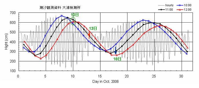
Fig.2. Tide level at Oura station (height from a base level)
(Click to View Enlarged Image)
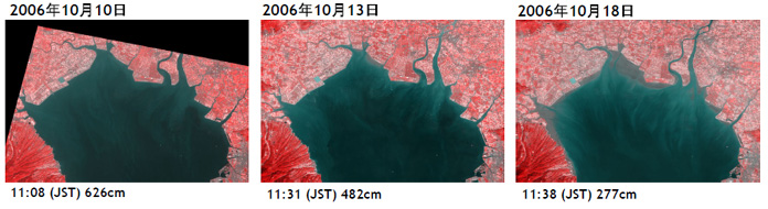
Fig. 3. Zoom-up of the northern Ariake sea on October 10, 13, and 18.
They are assigned the near-infrared channel to R of RGB and assigned the red channel to G and B.
(Click to View Enlarged Image)
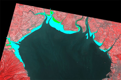
Fig. 4. Areas where near-infrared radiance became high on Oct. 13 and 18.
(Click to View Enlarged Image)
Fig. 3 shows the northern Ariake sea by another channel sets.
Since water absorbs near-infrared light, the red color and dark color indicate the land above and below the sea surface respectively.
Fig. 4 shows areas where the land became above the sea surface on Oct. 13 (yellowish green), and on Oct. 18 (light blue).
We could detect the tidal flats by comparing two or more images and the optimal channels.
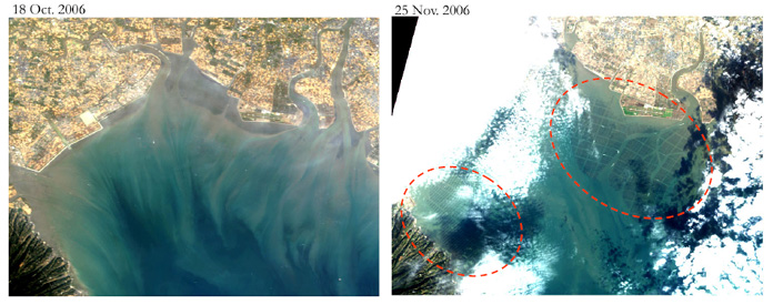
Fig. 5. RGB images of the northern Ariake Sea on Oct. 18, 2006 and Nov. 25 by AVNIR-2 (true color image)
(Click to View Enlarged Image)
Above figures are zoom-up images of the northern Ariake Sea.
Nori cultivation which has been started in October is seen clearly in the image in November (the areas enclosed with the red ellipse).
Thus the combination of two or more satellite images, in-situ observation and information will contribute to monitoring of the coastal environment such as tidal-flat changes and cultivation, and understanding of the coastal processes.
©JAXA EORC