Data Application Researches
4. Land Use Monitoring and Land Cover Classification
Land Use Classification Map by Optical Sensor
4. Land Use Monitoring and Land Cover Classification
Land Use Classification Map by Optical Sensor
Land Use Classification Map of Northern Chiba Prefecture, Japan
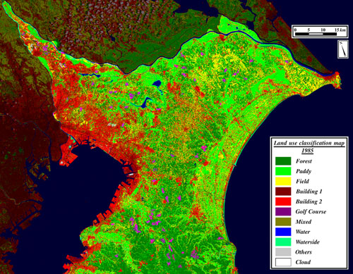
Fig. 1: Land Use Classification Map in Chiba Prefecture, Japan.(Click to View Enlarged Image)
 This land use map is generated by classification of Thematic Mapper (TM) onboard Landsat. Urban and industrial area is spread out along the Tokyo bay, and agricultural area and forest is on the east, Boso Peninsula.
This map is processed by unsupervised classification, and modified manually by existing thematic maps and ground truth. It is important for automatic and accurate land use/land cover mapping to set up the appropriate class and to develop the feasible classification algorithm.
©JAXA EORC