Seen from Space 2010
Nara: The 1,300-Year-Old Ancient Capital of Japan
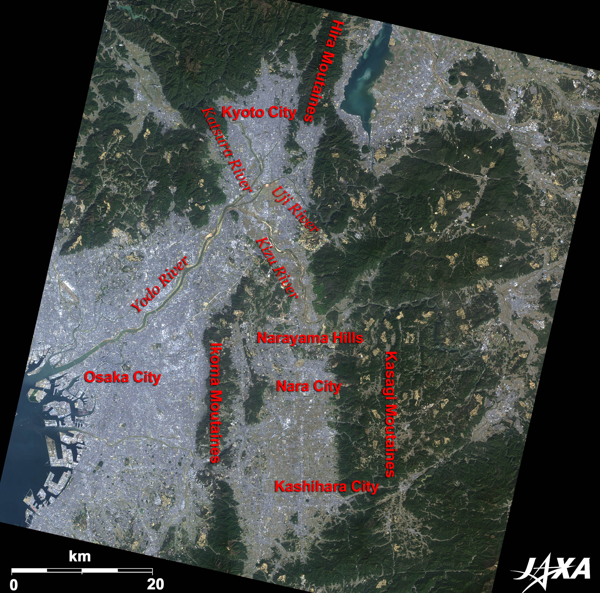  Fig. 1. Kyoto, Osaka, Nara and Their Surroundings
Figure 1 shows Kyoto, Osaka, and Nara—the major cities in the Kinki District (the central district in the middle ages in Japan)—as observed by ALOS (“Daichi”) in February 2009. Hilly land covered by dark green forest stretches from the north (Kyoto) to the south (Nara). This is the result of fault activities and Nara is located on a basin sandwiched by two parallel faults. You can see flat ground at the lower left of the image. The Katsura River, the Uji River, and the Kizu River join at the border of Kyoto and Osaka, and become the Yodo River, which flows into Osaka Bay. Osaka has developed at the mouth of the river. The Hill of Nara separates the Nara Basin and Kyoto District in the north and the Ikoma Mountains separate the Nara Basin and Osaka District in the west. Nara, which became the capital of ancient Japan in 710 and was called Heijo-kyo (capital), is located north of the Nara Basin. Heijo-kyo was a big city with an estimated population of hundreds of thousands. 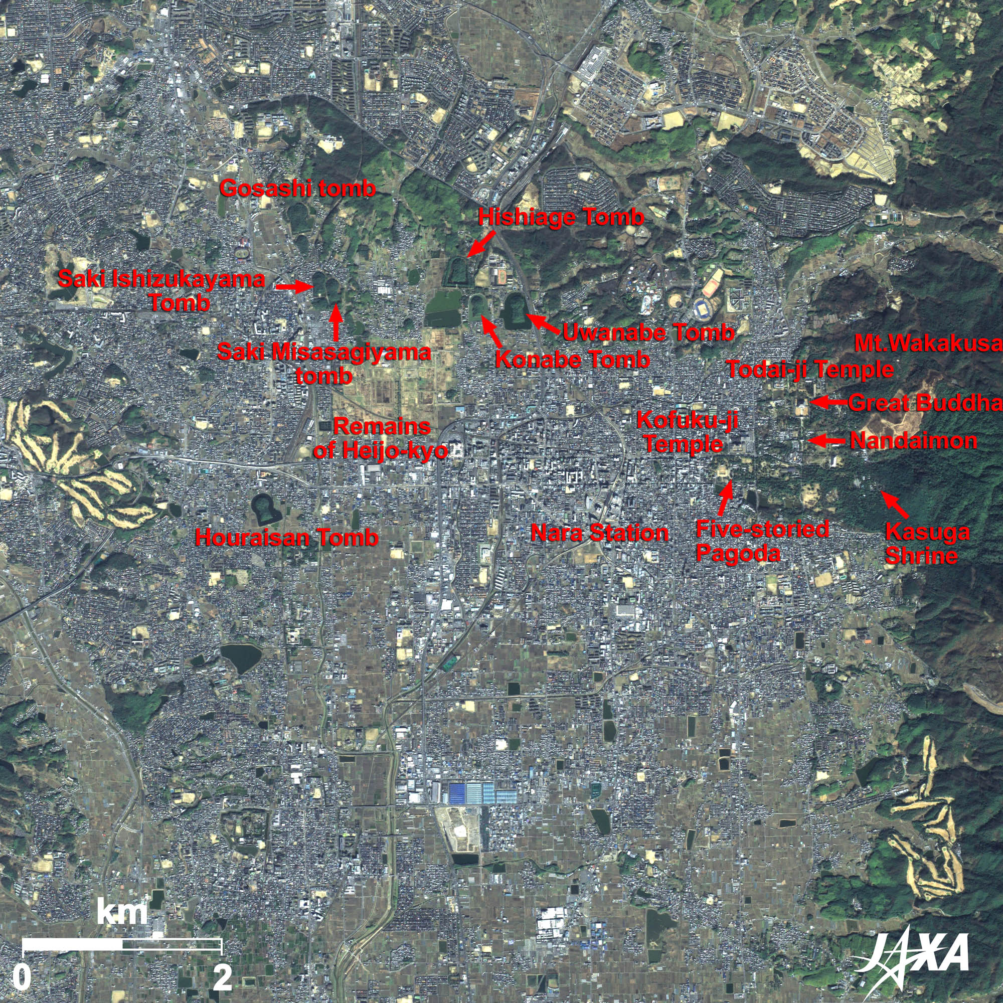  Fig. 2. Enlarged Image of Central Nara
Figure 2 is an enlarged image of central Nara. Nara is seen as bluish-grey in the middle of the image. The remains of Heijo-kyo are the light brown area slightly north of the center of the image. There are many remains of the ancient burial mound period. You can see three large keyhole-shaped tomb mounds in the upper part (north) of the image. The northernmost Hishiage Tomb (219 meters long) is said to be a tomb for the wife of Emperor Nintoku. It is unknown who is buried in the other two tombs: Uwanabe Tomb (204 meters long) and Konabe Tomb (255 meters long). Horaisan Tomb (227 meters long), seen in the central west, is believed to be the tomb of Emperor Suinin. The oldest Japanese history book, the Nihon-shoki, told that the emperor abolished the custom of burying living people as a sacred ceremony and instead ordered the people to bury clay figures. You can see Mt. Wakakusa east of Nara Station. Nara Park is located at the foot of the mountain and deer are kept in pasture. In this park are Kofuku-ji Temple, with its five-storied pagoda and Tokondo (the main hall); Kasuga Shrine, home to the guardian god of the capital; Todai-ji Temple, where the famous Great Buddha sits; and Nandaimon (Great South Gate). 
Nara, the Ancient Capital, Celebrating its 1,300-Year AnniversaryEmperor Monmu asked aristocrats to move the capital from Fujiwara-kyo to Heijo-kyo (Nara) in 707. The following emperor, Genmei, issued an imperial rescript in 708 to move the capital to Heijo-kyo. Two years later, the capital was moved to Heijo-kyo before construction was completed. The capital was designed to have a large main avenue (Suzaku-oji) running north and south and other smaller streets crossing the avenue. Heijo-kyo was the capital for 74 years—eight generations of emperors—until Emperor Kanmu moved it to Nagaoka-kyo in southwestern Kyoto. Fujiwara-kyo was located in Kashihara City, Nara prefecture, about 20 km south of Nara City, as seen in Figure 1. Heijo-kyo was the political and cultural center during establishment of the old national governmental system. It is also home to the Remains of Kashihara of the Jomon period (the Neolithic era in Japan) and emperor’s tombs. 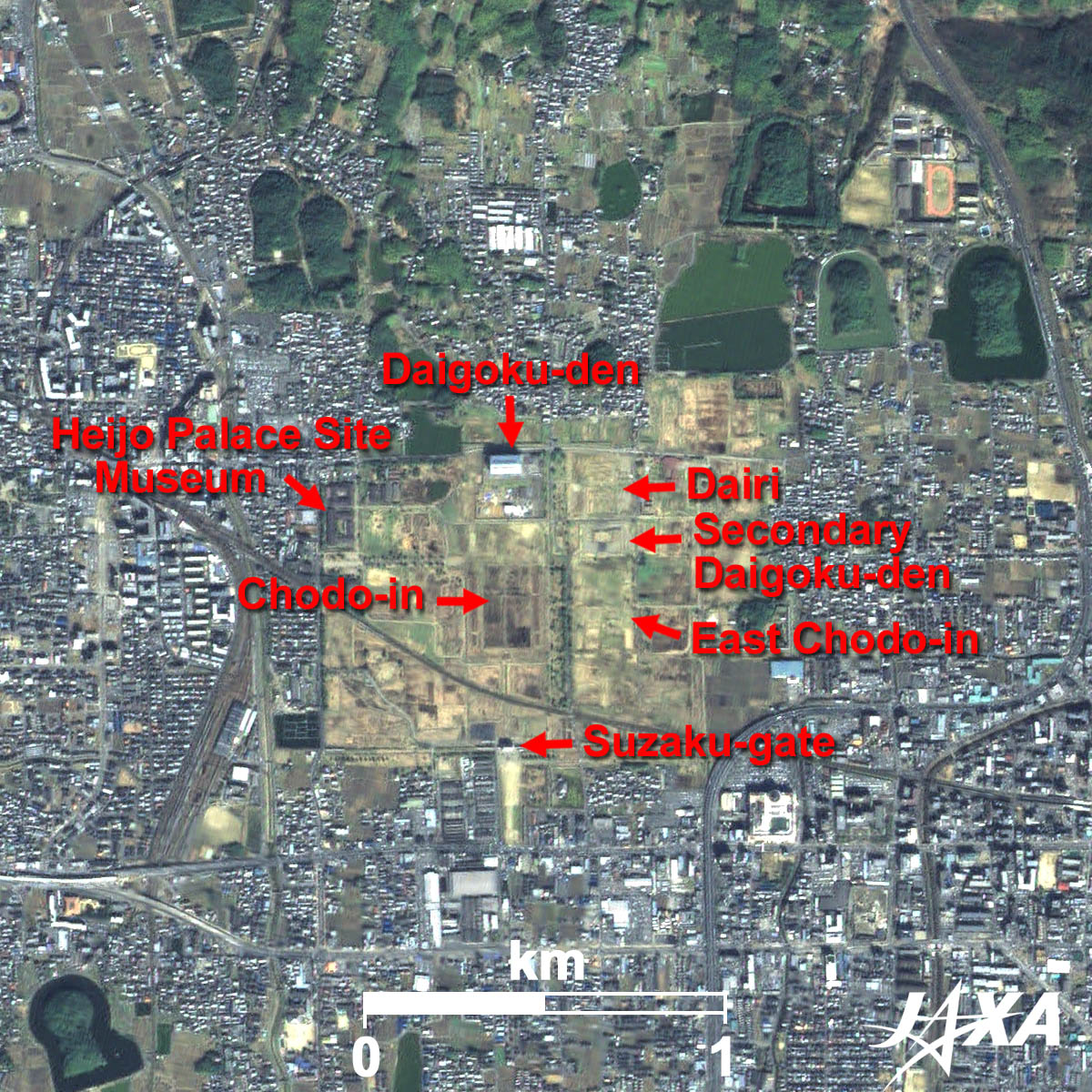 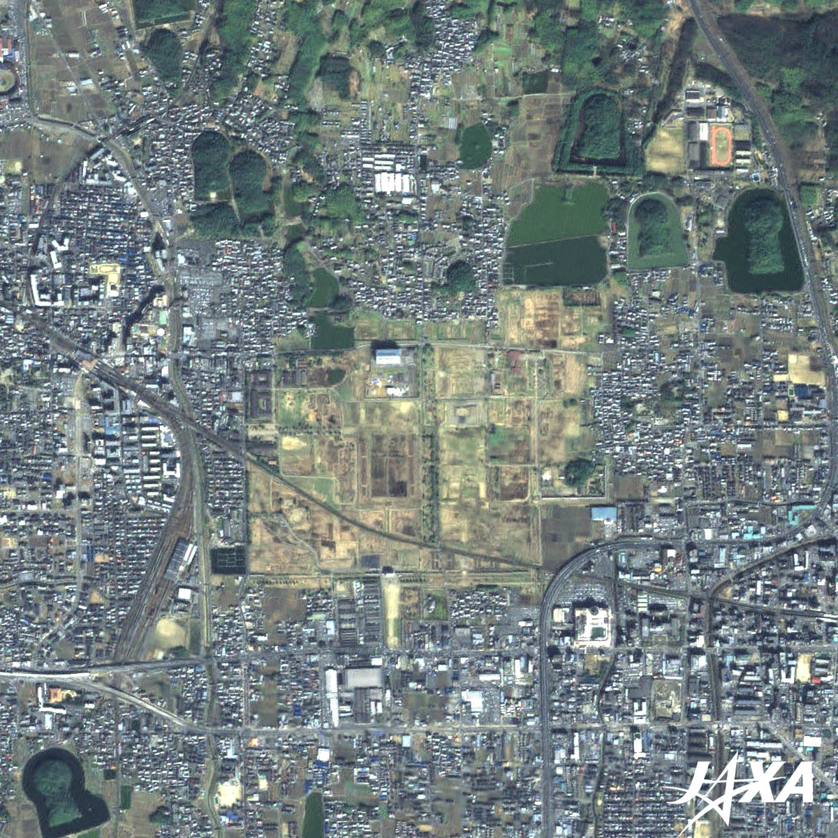 Fig. 3. Enlarged Image of the Remains of Heijo-kyo
Heijo-kyo (kmz, 3.14 MB, High Resolution) as seen on Google Earth Figure 3 is an enlarged image of the remains of Heijo-kyo. Emperors resided in the northern part of Heijo-kyo. Suzaku-mon (the main gate of the palace) has already been restored, and Daigoku-den (the central facility of the palace) is in restoration. In the south, was the Chodo-in (government facility) where civilians and soldiers assembled during formal ceremonies; and in the east, were the Dairi (governmental facility for emperors), the secondary Daigoku-den, and the East Chodo-in. At the end of the Edo era (around the middle of the nineteenth century), an officer named Kitaura surveyed this area, which resulted in the preservation of the remains of Heijo-kyo. Ceremonial events will be held at the remains of Heijo-kyo from April 24 this year. A restored ship that sent an envoy to the Tang Dynasty of China in the Nara era will also be on display. Daichi satellite images are used for the background image of Yahoo! Maps. When you click the “picture” button in the upper-left corner of the image, the background image will change to an image taken by Daichi. Explanation of the Images:
AVNIR-2 has four observation bands. The color composite images are usually produced by assigning red to Band 3 (610 to 690 nm), green to Band 2 (520 to 600 nm), and blue to Band 1 (420 to 500 nm). In the above images, green is assigned to the sum of 95% of Band 2 and 5% of Band 4 (760 to 890 nm), which improves the visibility of vegetation and the resulting images have natural coloring as if seen by the naked eye. Thus, each color indicates the following ground objects:
PRISM is an optical sensor for observing ground surfaces with visible and near-infrared signals in the 520- to 770-nanometer (one-billionth of a meter) band. The image is monochromatic but has a higher resolution. PRISM has three independent optical systems to acquire images in the view of nadir, forward, and backward simultaneously. Only the nadir images are used in these figures. The above AVNIR-2 color composite image is decomposed into, hue, saturation, and intensity. The intensity portion is replaced by PRISM data. The hue, saturation, and intensity data are then reversed into a color image. This color image has a virtual 2.5-m resolution. A color image composed by combining a higher resolution monochromatic image and a lower resolution color image is called a pan-sharpened image. The color composite image is produced by assigning red to Band 3 (630 to 690 nm), green to Band 2 (520 to 600 nm) and blue to Band 1 (450 to 520 nm). The resulting image has natural coloring as if seen by the naked eye. |


