ページの先頭です。
本文へジャンプする。
【Important Notices】This page is an archive page of information published in the past. Since the update has been completed, it may contain broken links or outdated information. For the latest information, please use the new site Earth-graphy (earth.jaxa.jp).
ここからサイト内共通メニューです。
サイト内共通メニューを読み飛ばす。
サイト内共通メニューここまで。
ここから本文です。

Seen from Space 2009

Nostalgia for Europe in the "Paris of South America"- Buenos Aires, Argentina


Fig. 1. Buenos Aires and Vicinity

Figure 1 depicts Buenos Aires and its vicinity as observed in March 2008. The gray area in the center of the figure is Buenos Aires, the capital of Argentina (Argentine Republic), located on the Atlantic coast of the South American continent. It has developed as a port town on the shore of the La Plata River (Río de la Plata), which is open to the Atlantic Ocean, and is one of the largest cities in South America with a population of 3 million. The large tan belt in the center of the figure is the great La Plata River. Its basin area (3.6 million square kilometers), including the Paraná and Uruguay rivers, is the fifth largest in the world. The swollen rivers look tan from the eroded red earth they carry.
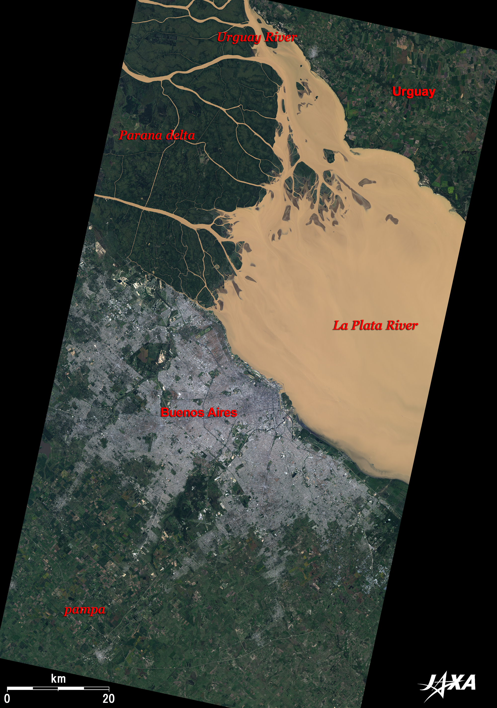
Río de la Plata means "Silver River" in Spanish. The origin of this name goes back to a Spanish explorer of the "Age of Geographical Discovery" in the early 16th century, who mistakenly saw this land as a silver-rich locality. The land extending on either bank of the La Plata River (with Uruguayan territory in the upper right and Argentinian territory in the lower left of the figure), looking like "dazzle paints" with its green forests and farmlands, is a fertile "Pampa" prairie supporting Argentina’s main industries of agriculture and cattle breeding.

Fig. 2. Close-up Image of Buenos Aires
Buenos Aires, Argentina (kmz, 5.12 MB, Low Resolution) as seen on Google Earth.
Figure 2 presents a close-up image of Buenos Aires. The downtown area extends along the flat Pampa prairie facing the La Plata River, where modernistic buildings stand neatly in a grid along the streets. The long piers jutting out into the river are landmarks of the Port of Buenos Aires, from which point the town began its growth. A railroad is visible beside the port, laid down to carry agricultural and livestock products to the harbor from the Pampa. The neo-Gothic, European-style Retiro Station serves as the terminal for the railroad. The green Plaza San Martin is located just south of the station. There stands a heroic mounted statue of José de San Martín, a 19th-century general who led the Argentinian struggle for independence from Spain.
The vast green area in the Palermo district in the upper left of the figure is Parque 3 de Febrero (February 3 Park, commonly called Palermo Park). This 1000-acre area, which is a place of relaxation for local citizens, has a variety of recreation facilities such as golf courses, a horse racetrack, a tennis club, a zoo, a rose garden, a Japanese garden, and so on.

The tango is the most famous aspect of the culture in Argentina, but with the great interest of the citizens in plays, music, and art, there are many theaters and art museums in the city. In particular, the Colón Theater (which celebrated the 100th anniversary of its establishment in 2008) is one of the three major theaters of the world, together with La Scala in Milan and the Paris Opera House. It faces the world’s widest avenue, Avenida 9 de Julio (July 9 Avenue), which penetrates the city from north to south. The round, chalky Obelisco (the Obelisk) stands in the center of the avenue near the theater like a signpost. Beyond the street, running aslant toward the southeast, is the brownish Plaza de Mayo (Plaza of May). This name is based on the revolution that took place in May 1810, triggering the independence movement. The pink presidential palace, Casa Rosada, is visible in front of the Plaza. The Plaza serves as the forecourt of the palace, and a multitude of citizens gather there on every occasion, such as presidential inaugurations, protest demonstrations, etc.

Argentina is well known as a country of football aficionados, and Argentina won the gold medal in football at the 2008 Beijing Olympic Games. Naturally, there are many football stadiums in the city. Visible in the old La Boca district in the lower right of the figure is the stadium of the famous "Boca Juniors" football club. Diego A. Maradona, the golden boy of the Argentinian team that won the championship at the 1986 FIFA World Cup in Mexico, once played in this club. Boca is famous as the place where the first immigrants from Europe landed and also as the birthplace of the tango.

Argentina is a long, big country (3800km north-to-south, 2.8 million square kilometers) about 7.5 times as large as Japan, and has every kind of climate on Earth in a single country. The name of the country was derived from the Latin word "argentum" meaning "silver." Almost 80% of its exports consists of agricultural and livestock products, but in keeping with its original name, investment in the mining industry has increased in recent years. Buenos Aires is located in the middle of this long country, in a mild climate zone with four clear seasons like those in Japan (though summer and winter are inverted in the southern hemisphere). The scenery there is the result of a free, open atmosphere peculiar to the New World and the culture that came about through the immigration policies initiated in the 19th century. The city is referred to as the "Paris of South America", and the townscape of purified old European-style architecture reflects a deep nostalgia for Europe.


Explanation of the Images:

(Click the images twice to enlarge.)
Satellite: Advanced Land-Observing Satellite (ALOS) (Daichi)
Sensor: Advanced Visible and Near-Infrared Radiometer-2 (AVNIR-2) and
Panchromatic Remote-Sensing Instrument for Stereo Mapping (PRISM)(Fig. 2)
Date: 1359 (UTC) on March 16, 2008 (AVNIR-2 and left image of Fig. 2 by PRISM)
1358(UTC) on May 1, 2008 (right image of Fig. 2 by PRISM)
Ground resolution: 10m (AVNIR-2) and 2.5m (PRISM)
Map Projection: Universal Transversal Mercator (UTM)
AVNIR-2 has four observation bands, three of which fall in the visible-light range. Composite images are usually produced by assigning red to Band 3 (610 to 690nm), green to Band 2 (520 to 600nm), and blue to Band 1 (420 to 500nm). The resulting images have natural coloring, as if seen by the naked eye. Thus, the following colors designate ground objects.

Green: Grass fields or farmlands
Grey: City area or roads
Reddish brown: Tennis courts
Tan: Muddy water of La Plata River
Dark green: La Plata River delta

Fig. 2
PRISM is an optical sensor for observing ground surfaces with visible and near-infrared signals in the 520 to 770 nano-meter (one-billionth of a meter) band. The acquired image is monochrome. PRISM has three independent optical systems (telescopes) to acquire images for nadir, forward, and backward views at the same time. Only the nadir image was used in this article.
The above AVNIR-2 composite image was transformed into hue, saturation and intensity data, and the intensity was replaced by the PRISM image. The hue, saturation and intensity data were then recombined into a color image. As a result, a virtual 2.5m ground-resolution color image was obtained. This kind of high-resolution color image, created by combining a higher-resolution monochrome image and a lower-resolution color image, is called a pan-sharpened image.

Related Sites:
ALOS Research and Application Page
The World's Great Falls (Part 3) Iguazu Falls: A Thundering Roar of the Earth between Argentina and Brazil
Wetland monitoring by optical sensors and microwave radars
Paris: City of Art Surrounded by Two Forests and Circular Roads
Andean Cordilleras and Gran Chaco - Dry Alps and Prairie
Land, Seen from Space
本文ここまで。
image:Satellite Navigator
image:Satellite Applications and Operations Center(SAOC)
Earth Data Collection by JAXA Satellites
image:ページTOP