ページの先頭です。
本文へジャンプする。
【Important Notices】This page is an archive page of information published in the past. Since the update has been completed, it may contain broken links or outdated information. For the latest information, please use the new site Earth-graphy (earth.jaxa.jp).
ここからサイト内共通メニューです。
サイト内共通メニューを読み飛ばす。
サイト内共通メニューここまで。
ここから本文です。

Seen from Space 2008

Augusta: The Garden City of Georgia, the United States

 
Fig. 1. Vicinity of Augusta, Georgia
(Full Image)
Figure 1 depicts the vicinity of Augusta, Georgia in the southeast United States of America as observed in April 2007. Augusta is a name commonly used for females and places in English-speaking countries. The name was originally associated with Augustus, the first emperor of the Roman Empire, but the city was named in honor of Augusta, Princess of Wales, mother of King George III of the United Kingdom.
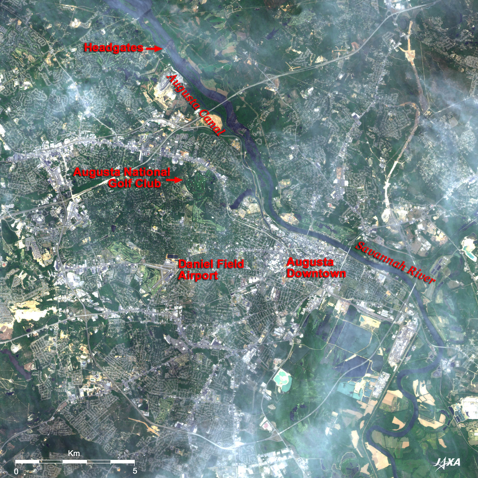
Many cities such as Philadelphia and Washington, D.C. in the eastern United States are located along a geographical feature known as a fall line. This fall line forms the boundary between the Piedmont Hills in the east Appalachian Mountains and the coastal plain across which rivers from the upland region drop to the plain as falls or rapids, and cities located there are called fall line cities.
Augusta is a fall line city located in the middle of the stream of Savannah River which flows from the upper left to the lower right in the figure.

Augusta has developed as one of the world's largest cotton markets and is now the second largest city (with a population of 190,000) in Georgia after the state capital Atlanta (with a population of 420,000) located about 240km to the west.

Augusta Canal running parallel to the Savannah River was built for water resources in 1845.
Augusta is now famous for the Masters Tournament.
The Augusta National Golf Club is located about 5km northwest of Augusta. Unlike the other three major tournaments that change courses every year, the Masters is held at the same venue in early April. The tournament in 2008 took place from April 10 to 13. Daniel Field, located about 7km west of the city, is a private airport mainly used by golfers and patrons of the Masters Tournament. Augusta Regional Airport in the city's south side is the main airport (not visible in the figure).

Fig. 2. Augusta National Golf Club Course
Figure 2 presents the Augusta National Golf Club course. The greatest amateur golfer, Bobby Jones, and golf-course designer Alister MacKenzie built this course in December 1932, and it opened for play in January 1933. Located on the site of a former tree nursery, this course is now one of the most beautiful golf courses in the world. The first Masters Tournament was held in 1934. The course is well known for its botanic beauty as well. Each hole on the course is named after a tree or shrub such as Tea Olive, Flowering Peach, and Flowering Crab Apple with which it has become associated.
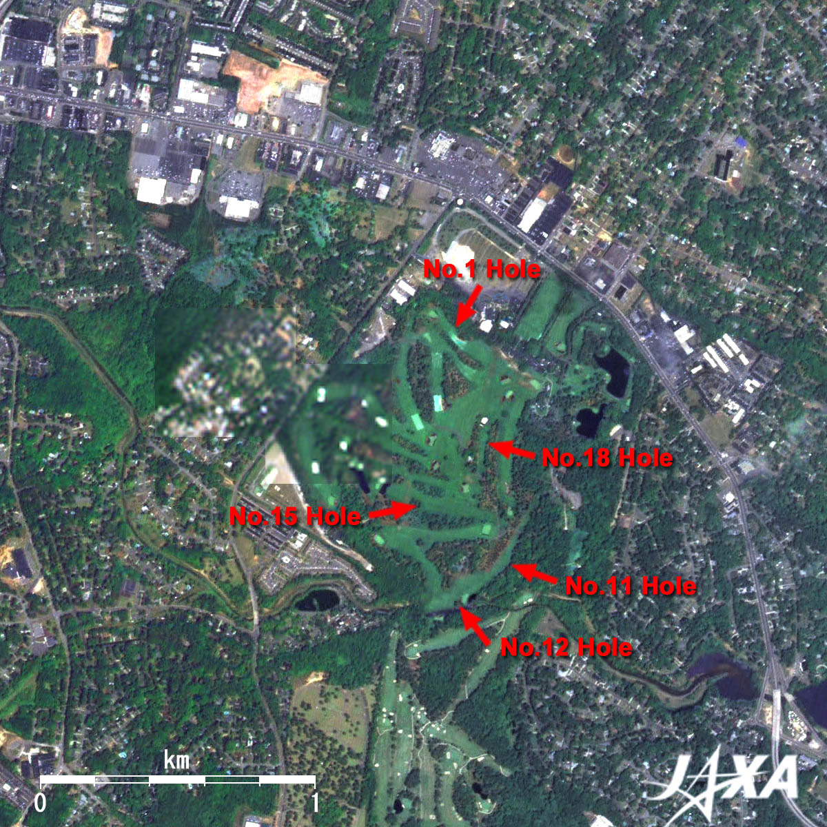
Augusta is also famous for being a very tough course. Large contours, fast greens, and frequently changing wind direction make top players struggle to overcome the course. Holes by the water such as Hogan Bridge (12th), Nelson Bridge (11th), and Sarazen Bridge (15th) are particularly difficult. The 11th, 12th, and 13th holes at Augusta were termed "Amen Corner" because of the critical play on the final day in the 1958 Masters. A sportswriter gave this name in an article in a 1958 issue of Sports Illustrated, and this is the 50th year of "Amen Corner." His inspiration for the name came from a jazz record titled "Shouting at Amen Corner."

This course usually opens for play from October 1 and closes just after the Masters. It can be said that this course just exists for the Masters. Augusta National Golf Club is a limited private course that has about 300 members at any given time. Membership is strictly by invitation. This course is not open to the public since sponsorship by a member is required for play.
The golf course visible at the bottom of the figure is the Augusta Country Club. A major change in the Augusta National Golf Club took place in 2002 with the partial acquisition of the Augusta Country Club.

Fig. 3. Close-up of Augusta Urban Area
Augusta (kmz, 3.99MB, Low Resolution) as seen on Google Earth.
Figure 3 presents a close-up image of the urban area of Augusta. Augusta is an attractive city. Known as "The Garden City," it maintains a historic townscape of the southern United States and mansions built before the Civil War. Woodrow Wilson's (28th president of the United States) childhood home and George Walton's (the youngest signer of the Declaration of Independence) home are specified as historical sites. Visitors can walk along the Savannah River on the Augusta Riverwalk in downtown. In the late 1970s, businesses started leaving downtown Augusta, and that started a trend of urban abandonment and decay. To counter this trend, city politicians and business leaders promoted revitalizing Augusta's hidden riverfront (obscured by a levee) into a beautiful Riverwalk with parks, an amphitheater, hotels, museums, and art galleries.

Augusta is also known for its medical care. The Medical College of Georgia (MCG) is the core facility. The Radiology Department of MCG's School of Medicine is one of the top three in the United States, and they conduct high-level treatment research in cancer, cardiovascular functional disorder, neuroscience, infection disease, etc.


Explanation of the Images:


Figs. 1 through 3. (Click the images twice to enlarge.)
Satellite: Advanced Land-Observing Satellite (ALOS) (Daichi)
Sensor: Advanced Visible and Near Infrared Radiometer-2 (AVNIR-2) (Figs. 1 through 3 and Full Image) and
Panchromatic Remote-sensing Instrument for Stereo Mapping (PRISM)(Figs. 2 and 3)
Date: 1619 (UTC) on April 28, 2007 (Figs. 1 through 3 and Full Image, AVNIR-2)
1618(UTC) on June 13, 2007 (Fig. 2 and 3, PRISM)
Ground resolution: 10m (AVNIR-2) and 2.5m (PRISM)
Map Projection: Universal Transversal Mercator (UTM)
Figs. 1 through 3 and Full Image
AVNIR-2 has four observation bands. The composite images are usually produced by assigning red to Band 3 (610 to 690nm), green to Band 2 (520 to 600nm), and blue to Band 1 (420 to 500nm). In the above figures, green is assigned to the sum of 90% of Band 2 and 10% of Band 4 (760 to 890nm), which improves the visibility of vegetation. The resulting images have natural coloring as if seen by the naked eye. Thus, the following colors designate ground objects.

Green: Forests
Light green: Farmlands, grass fields or golf courses
Grey: City area or roads
Reddish brown: Brick buildings
Blue: Water surfaces

Figs. 2 and 3
PRISM is an optical sensor for observing ground surfaces with visible and near-infrared signals in the 520 to 770 nano-meter (one-billionth of a meter) band. The acquired image is monochrome. PRISM has three independent optical systems (telescopes) to acquire images for nadir, forward, and backward views at the same time. Only the nadir image was used in this article.
The above AVNIR-2 composite image was then transformed into hue, saturation and intensity, and the intensity was replaced by the PRISM image. The hue, saturation and intensity data were then reversed into a color image. As a result, a virtual 2.5-m ground resolution color image was obtained. This kind of high-resolution color image, composed by combining the higher-resolution monochrome image and the lower-resolution color image, is called a pan-sharpened image.

Related Sites:
ALOS Research and Application Page
The World's Great Falls (Part 1) Iridescent Niagara Falls in USA and Canada
Boston, Birthplace of USA and Cambridge, City of Universities
Seattle, Washington: Emerald City surrounded by Green and Water
The City on the Mississippi Delta: New Orleans, Louisiana
Land, Seen from Space
本文ここまで。
image:Satellite Navigator
image:Satellite Applications and Operations Center(SAOC)
Earth Data Collection by JAXA Satellites
image:ページTOP