ページの先頭です。
本文へジャンプする。
【Important Notices】This page is an archive page of information published in the past. Since the update has been completed, it may contain broken links or outdated information. For the latest information, please use the new site Earth-graphy (earth.jaxa.jp).
ここからサイト内共通メニューです。
サイト内共通メニューを読み飛ばす。
サイト内共通メニューここまで。
ここから本文です。

Seen from Space 2007

Samarkand, Uzbekistan- "The Blue City"/"The Gem of The East" once-flourishing on the Silk Road

 
Fig. 1 Samarkand and Vicinity
(Full Image)
This image acquired in June 2007 depicts Samarkand (Samarqand in Uzbek) in Uzbekistan. The grey area in the center of the figure is Samarkand, the second largest city of Uzbekistan and referred to as "The Blue City" or "The Gem of the East." Unfortunately, the city area is partially covered by faint white clouds. The dark brown area to the upper left of the cloud is its shadow. Samarkand Airport is visible in the upper part of the figure. Japan is supporting the construction of this airport through Official Development Assistance (ODA). The river in the upper right of the figure is Zeravshan River flowing from eastern Tajikistan. Canals from this river developed, and wheat and cotton fields spread around Samarkand. This river was the largest branch of the Amu Darya River, one of the two great rivers in Central Asia. However, as a result of water consumption for irrigation, it disappears south of the Qyzylqum Desert, which spreads from 300km northwest of Samarkand and occupies the majority of western Uzbekistan.
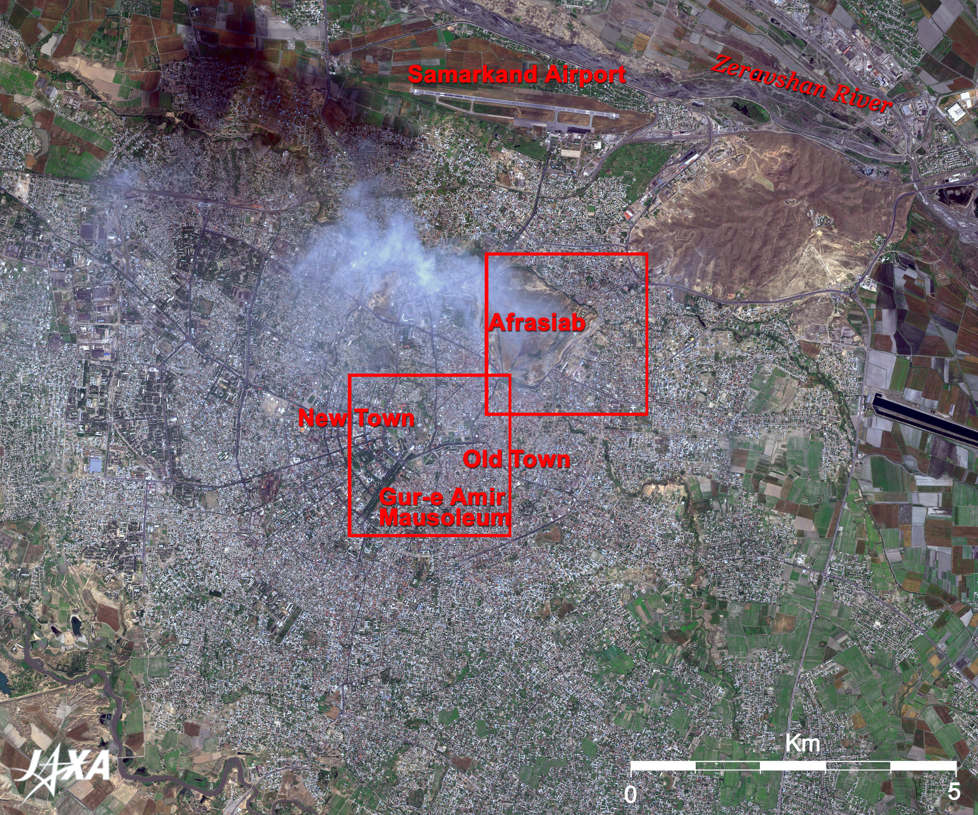
The eastern area of the city is the old city where many historical heritages remain, and the western area is the new city developed by city planning during the Soviet era. A geometrically ordered city structure in the left half of the city can be seen from the figure.
In old times, it was called Marakanda of Sogdian and was developed through trading since about the 10th century B.C. as one of the most important oasis cities on the Silk Road. It was called the "Crossroads of Cultures" and was always most noted for and prospered from its central position on the Silk Road. However, in 1220, Genghis Khan destroyed the town built on the hill of Afrasiab, burning it to ashes. It was hero Timur the Lame (1336-1405) who revived Samarkand. He collected art at that time and architectural skills as soon as he made Samarkand the capital of the empire and revived it as a remarkable city in the Islamic world. The Gur-e Amir Mausoleum is located in the middle of the city. Timur built this mausoleum for his grandson but with time, it became the king's mausoleum of the Timurid dynasty including himself.

Fig. 2 Close-up Image of Registan Square
Samarkand (kmz, 1.60MB, Low Resolution) is seen from Google Earth.
Fig. 3 Close-up Image of the Ruins of Afrasiab
Although it is not clear in Figs. 2 and 3, most of the historical buildings have blue domes. The blue of the turquoise color that Timur liked was called "Samarkand Blue," from which the name "The Blue City" was derived.
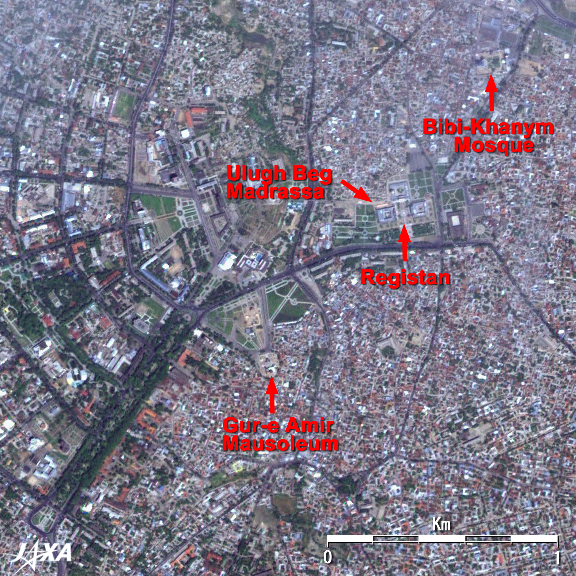
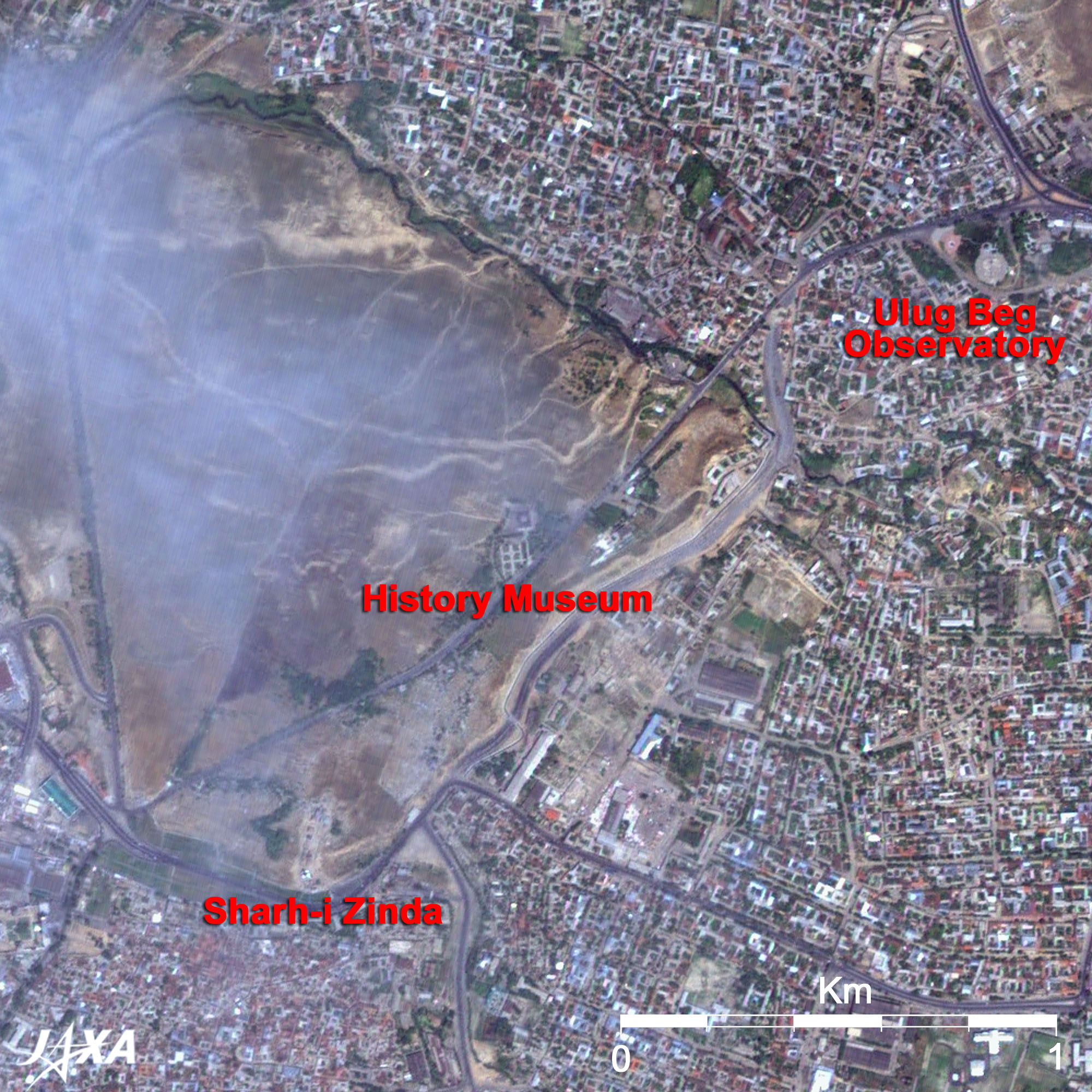
Today's Samarkand centers on Registan Square, and many historical landmarks that recall old times are concentrated around the square. Three huge madrassas (Islamic seminary) surrounding the square are visible. They are, from right to left, Sherdar Madrassa with decorations featuring a roaring lion; Tilla-Kari Madrassa, which boasts gilded decorations on the inner wall of the blue dome; and Ulugh Beg Madrassa built by astronomer Ulugh Beg, the grandson of Timur.
Bibi-Khanym Mosque is located on the northeast of the square. Bibi-Khanym is said to be the name of Timur's wife, and this grand mosque was constructed in 1404. This was once the largest mosque in the Islamic world.
To its east, the brownish area, partially covered by clouds in Fig. 3, is the hill of Afrasiab, i.e. the ruins of ancient Samarkand. Shah-i Zinda complex on the south foot of the Afrasiab hill is a vast necropolis of the Timurid dynasty related people. This is a sacred place for Muslims, and the variety of decorations and beauty of those mausoleums with domes is said to be the greatest in Central Asia. The most brilliant finding among the archeological excavations was the Sogdian frescos in the 7th century, and they are exhibited in the Afrasiab Museum located on the southeastern limb of the hill. The portraits of the Sogdian traders, an envoy from a foreign country having an audience with the king, and the life of people. are vividly drawn with great reality.
Ulug Bek Observatory is visible to the east of Afrasiab hill. Ulug Bek was a grandson of Timur and the 4th sovereign ruler of the empire. He was quite skilled in politics and diplomacy, and he was an exceptional administrator having a deep understanding for various cultures and spared no effort to support them. At the same time, he was a scientist as well as a ruler, and he was one of the top ten renowned astronomers of the world at that time. It is said that this was the place where he observed stars with a huge (40m high and 63m long) sextant, surrounded by a dome of three stories. Based on the observations here, he determined the length of one year with an astonishing accuracy less than one minute.
"Samarkand- Crossroads of Cultures" was added to the list of the World Heritage of the United Nations Educational, Scientific and Cultural Organization (UNESCO) in 2001.


Explanation of the Images:
Figs. 1 through 3
Satellite: Advanced Land-Observing Satellite (ALOS) (Daichi)
Sensor: Panchromatic Remote-sensing Instrument for Stereo Mapping (PRISM) , Advanced Visible and Near Infrared Radiometer-2 (AVNIR-2)
Date: 0629 (UTC) on June 1, 2007
Ground resolution: 2.5m (PRISM) and 10m (AVNIR-2)
Map Projection: Universal Transversal Mercator (UTM)
PRISM is an optical sensor for observing ground surfaces with visible and near-infrared signals in the 520 to 770 nano-meter (one-billionth of a meter) band. The acquired image is monochrome. PRISM has three independent optical systems (telescopes) to acquire images for nadir, forward, and backward views at the same time. Only the nadir image was used in this article.
AVNIR-2 is equipped with a pointing function by which it can shift its observation area perpendicular to ALOS's direction of travel and has four observation bands. The composite images are usually produced by assigning red to Band 3 (610 to 690nm), green to Band 2 (520 to 600nm), and blue to Band 1 (420 to 500nm). The AVNIR-2 composite image was then transformed into hue, saturation and intensity, and the intensity was replaced by the PRISM image. The hue, saturation and intensity data were then reversed into a color image. As a result, a virtual 2.5m ground-resolution color image was obtained. This kind of high-resolution color image, composed by combining the higher-resolution monochrome image and the lower-resolution color image, is called a pan-sharpened image.
Figures 2 and 3 are high-resolution, pan-sharpened images composed this way. The resulting image has natural coloring as if seen by the naked eye. Thus the ground objects are distinguished by the following colors.

Khaki or brown: Bare ground
Green : Farmlands
Bluish grey: City area or roads
Dark Blue: Water surfaces
White: Clouds
Figure 1 is the original AVNIR-2 image used to create the pan-sharpened images.

Related Sites:
ALOS Research and Application Page
Xīyóu Jì's World, Flame Mountains
Shrinking Sea in the Desert: The Aral Sea
Land, Seen from Space
本文ここまで。
image:Satellite Navigator
image:Satellite Applications and Operations Center(SAOC)
Earth Data Collection by JAXA Satellites
image:ページTOP