 Water Environments and Resources
Circumstances are now occurring that affect human activity globally: Frequently occurring natural disasters such as floods and droughts currently due to the climate changes affect not only local areas, but are global in scale. EORC monitors the global water cycle and combines satellite observation data and land numerical modeling to estimate physical amounts (river discharge and soil moisture, etc.), which will be key factors for solving issues such as water and food shortages and other related disasters. They provide hazard indexes as easily usable information (water cycle data set). They also promote analysis with the data integrated into ecosystem data, etc., to produce measures to satisfy the worlds demand for food and water for ten billion people.

Riko Oki
Associate Principal Researcher
Earth Observation Research Center
Space Technology Directorate 1
Constructing Global 0.5-degree Grid Resolution Land Simulation System - Soil Moisture Content

The system that used to have a 1-degree (about 100km) grid has now been changed to a much higher resolution of 0.5-degree (about 50km) grid for the land model, and a 0.25-degree (about 25km) grid for river models. In order to obtain the flood disaster level for a mid-sized river, EORC makes an estimation of the river discharge and flooded area rate.
Japan Area High-Resolution Land Simulation System Examination - Discharge Estimation for Kinugawa River Overflow at 3 O'clock on September 9, 2015
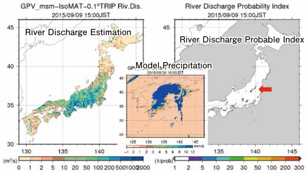
Provided by Mr. Yoshimura, Associate Professor, the University of Tokyo Simulation Result in Today's Japan (10km Grid)
A land model that is able to estimate local scale flood disaster (not achieved in any other place in the world) has been created by improving the spatial resolution from 10km to a much more accurate 1km. In addition, EORC provides water cycle data sets combined with satellite data and a hazard index to gather flood disaster data along domestic class-A rivers.
Development and Release of Global Satellite Mapping of Precipitation (GSMaP)'s latest version (GSMaP_NOW)
http://sharaku.eorc.jaxa.jp/GSMaP_NOW/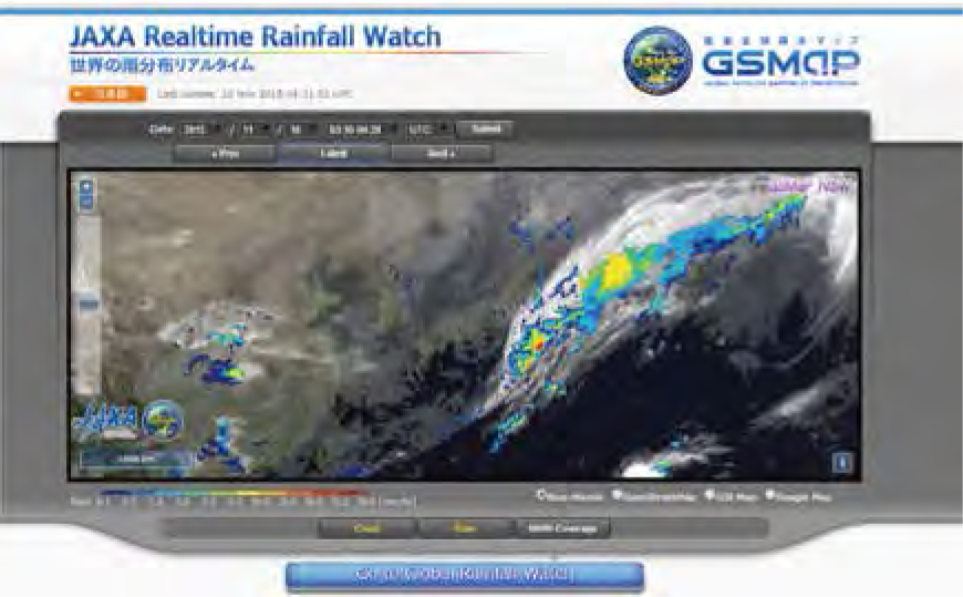
The precipitation distribution map has been prepared using only microwave radiation scale data (mainly the GMI sensor, the AMSR2 sensor over the area around Japan, and the AMSU direct received data) available within 30 minutes after observation within the observation range of the Geostationary Meteorological Satellite "Himawari". Furthermore, EORC prepares "real time" precipitation distribution maps on the hour and 30 minutes of every hour. This is to respond to requests for a reduced distribution time by many users, by extrapolating the map data for 30 minutes in the future, using the cloud motion vector calculated from the Geostationary Meteorological Satellite.


