Sri Lanka -201001
< Last Update: 24 Jan. 2013 >
SAFE Prototyping Status: January 2010 - December 2011 <Completed>
Assessment of Reliability of Fairly Accessible Data & Tools for Analyzing Impacts of Climate Change and Analysis of Risk of Sea Level Rise on Coastal Zone
Coast Conservation Department (CCD)
As an Island Nation in the Indian ocean, Sri Lanka coastal zone is vulnerable for the sever impacts due to climatic change but mainly due to sea level rise; Inundation, increased erosion, salinity intrusion, surges & wave over topping etc. Assessment of the hazards, vulnerabilities and risk are required for the identification of preparedness, adaptation and mitigation alternatives. But for the studies accessible and realistic data & tools should be available. Remote sensing and space based technology have become very important and timely tools for assessing coastal dynamics and related changes more easily and this project will target use of these technologies and application development within Coast Conservation Department (CCD), Sri Lanka. The objective of this prototype is the followings;
(1) Determine the availability, accessibility & reliability of data & tools for assessment of Climate Change impacts on coastal zone
(2) Execution & streamlining observations, measurements, data collection & monitoring programs at National & Regional Level for enhancing the assessment of impacts on climate change
(3) Assessment of risk on sea level rise spatially & temporally with available data
Participants
(1) Prototyping Executor
Eng. Bandula Wickramarachchi Coast Conservation Department (CCD), Sri Lanka
(2) Technical Supporter
- The University of Tokyo
- Geo-informatics Center (GIC)/Asian Institute of Technology (AIT)
(3) Data & Application Provider
- Japan Aerospace Exploration Agency: Satellite Images (ALOS-PALSAR, AVNIR)
- Survey Department, Sri Lanka:Arial Photographs, Topographic Data
- NARA, Sri Lanka: Sea level Measurements
- Ceylon Electricity Board: Wave Measurements
Final Results
1) Products or Findings
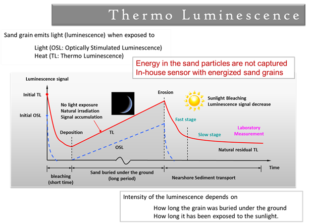
Thermo Luminescence
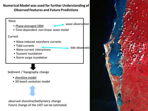
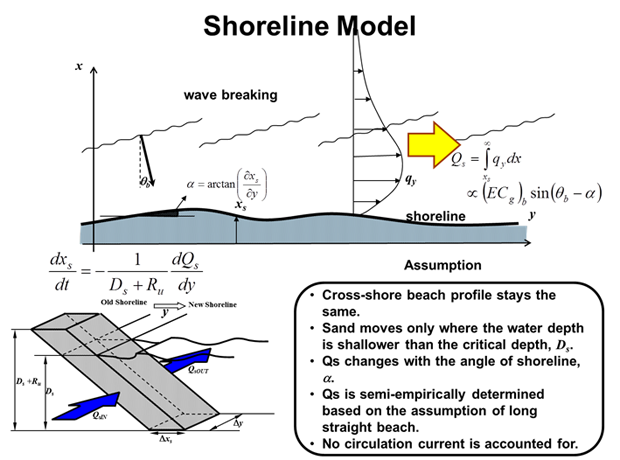
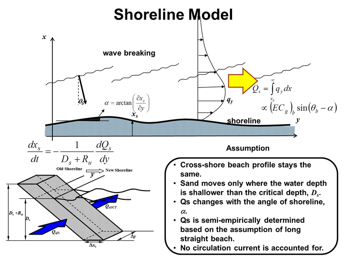
Shoreline Modeling
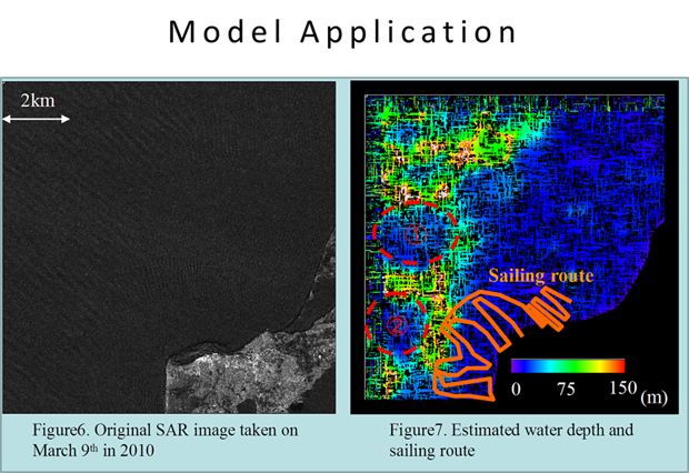
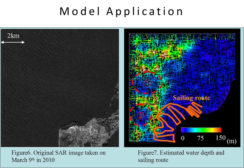
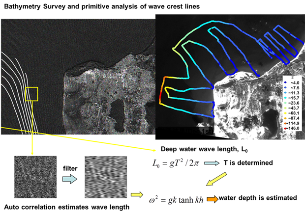
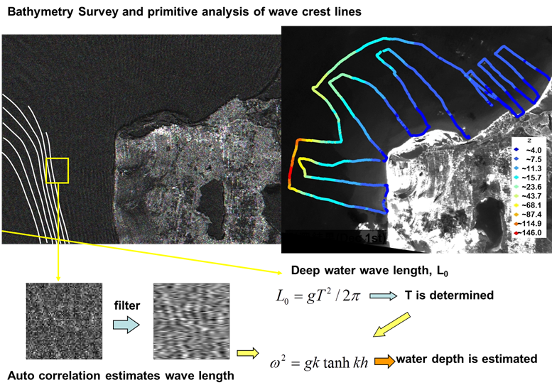
Bathymetry Estimation
Capacity Building
Training session (August 25, 2011)
2) Method
Thermo Luminescence
Shoreline Modeling
Bathymetry Estimation
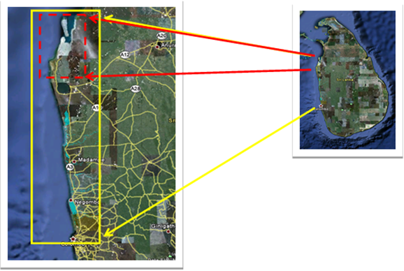
Study Area
Kalpitiya coastal area, entire west coast of the country
In-situ / Validation Data
(1) Place and Date Acquired Data
Kalpitiya coastal area (May 2010, July 2010, November&December 2010, and August 2011)
(2) Type of Parameter
Kalpitiya coastal area (May 2010, July 2010, November&December 2010, and August 2011)
a) Location Information (Latitude, Longitude) with GPS
b) Collecting Sand Sample
c) Sea Bed Depth with Sonar
d) Fixed-point Observation with Camera
Status of Utilization
(1) Input to Kalpitiya Tourism Project
a) Expert & User Group Meetings
Two meetings were conducted with Coastal Experts in the country & Government High Level officials involved in Kalpitiya Tourism Development Project.
b) Input to Interim Report
For the urgent decision making, Interim Report of the Project was released on the request of the Sri Lanka Government. Investors in the project area are officially instructed to follow the report for investment planning & EIA studies.t
(2) Stakeholder Meeting
The meeting was held with 80 Participants including State & Local Government, CBO, NGO & INGO and Private Developers from 45 Agencies/Institutions on August 25, 2011. The conclusions were;
- Thematic (Coastal) standard for land use category mapping
- Provision of results as evidence for land ownership court cases
- Review of tourism & fisheries master development master plans in the area
- Continue monitoring of the coastal area