Cooperation between The Thailand Government by GISTDA (Geo-Informatics and Space Technology Development Agency) and The Japanese Government by JAXA by using the data from (Pi-SAR-L) radar system to support Flood Management in Bangkok.
Because of many Thai people are affected by violence flood condition, JAXA is supported by Japanese Ambassador, Embassy of Japan in Thailand, to send airplane with radar (Pi-SAR-L) system to help Thailand Government to manage flood disaster in Bangkok Area. The Pi-SAR-L can take high resolution data with 3 meter spatial resolution same as ALOS-2 SAR in all weather. These data can be merged with images from THEOS’s satellite and other information to make Flood Map. The flood information including flood Map will provide presious inudated status in centeral Bangkok and suburban region including industrial complex in timely fashion, and those information will be expected to be utilized in Thailand Government's flood relief operations and disaster recovery operations.
The Pi-SAR-L airplane has schedule to fly on Nov.5 until the end of the month. And its operation flight is at Chiang Mai International Airport.
Achievement first flight to identify floodead area around Bangkok between 5-7 November, 2011.
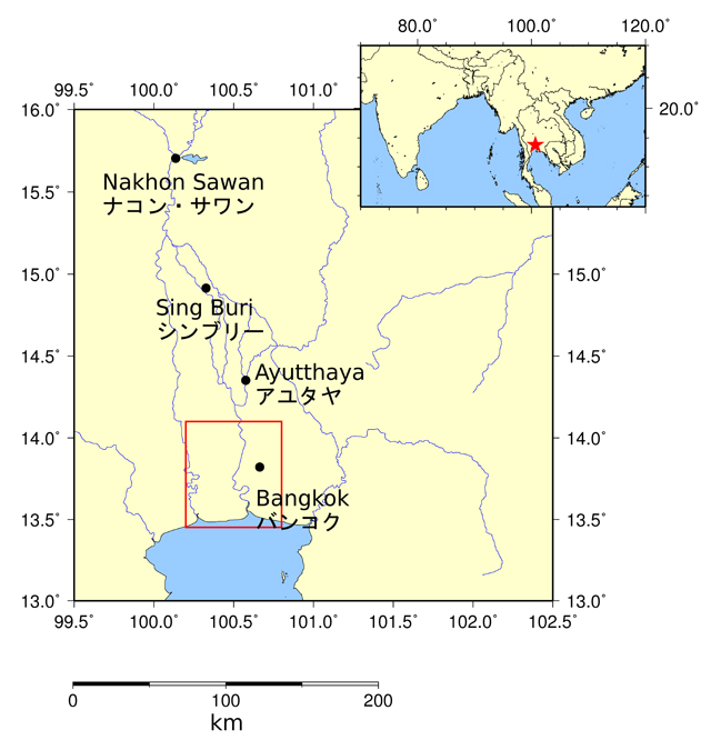
Fig.1: Location of Observation Area
The red square shows the Pi-SAR-L observation area.
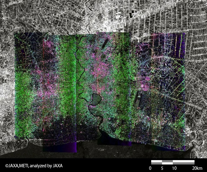
Fig.2: Color composite image of Bangkok, taken by Pi-SAR-L on Nov. 5th to Nov. 7th.
(Red: HH, Green: HV, Blue: VV)
Figure 2 shows the color composite image, which connected the data observerd by Pi-SAR-L on November 5 to November 7. The background is a image observed by Phased Array type L-band Synthetic Aperture Radar (PALSAR) installed on the Advanced Land Observing Satellite (ALOS, "Daichi").
In a Pi-SAR-L image, the place where the surface is covered with water becomes dark. It turns out that the area of east side and west side surrounding Bangkok have been filled with water. Although the wide area is covered with water by the flood, some areas near the cost are considered to be salt farms, shrimp-culture ponds, etc.
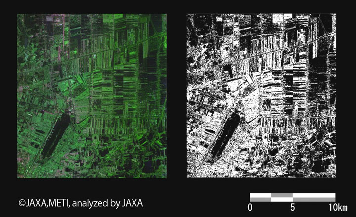
Fig.3: The map of flood region by Pi-SAR-L
(Left: Pi-SAR-L image / Right: flood region)
(Click to View Enlarged Image)
Figure 3 is the image near the Don Muang airport. It clearly shows the place which are covered with water (flood area and paddy field).
■: the place estimated to be covered with water
■: the place estimated to be covered with water
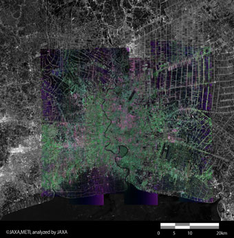
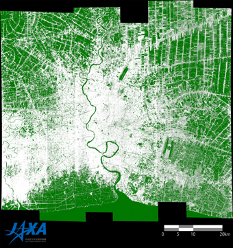
Fig.4: The flood map by using November 7th to 9th data
(Click to View Enlarged Image)
Figure 4 is the flood map by using Pi-SAR-L data, which were observed on November 7th to 9th. The place painted in green is estimated to be covered with water. This map shows the flood to the central Bangkok has begun.
Some salt farms and shrimp-culture ponds near the coast, and paddy fields in the northeast and the northwest part are also included to the green region.
By observation of Pi-SAR-L, GISTDA and JAXA have updated the flood map of the Bangkok city region by 2 or 3 days.
This year, by using earth observation data from satellites and aircraft, such as ALOS L-band synthetic-aperture-radar (PALSAR), JAXA engaged in collaborative research with Thailand's GISTDA that focused on three topics: flooding, coastal erosion monitoring, and rice yield estimation. The observations and analyses of severe rain fall damage presented herein were performed as part of the collaborative research.
JAXA plans to continue the joint research with GISTDA and utilize the findings from this project for future missions, including the Advanced Land Observing Satellite-2 (ALOS-2).
© JAXA EORC
Copyright©1997- JAXA EORC All rights reserved.