Northwestern Pakistan in the central Asia was seriously damaged due to floods and mudslides caused by heavy rain which had occurred since July 29, 2010. The Japan Aerospace Exploration Agency (JAXA) has performed the emergency observation to monitor the state of the damage by the Advanced Visible and Near Infrared Radiometer type 2 (AVNIR-2)* onboard the Advanced Land Observing Satellite (ALOS, "Daichi") at 14:44 (JST) or 5:44 (UTC) on August 5, 2010 further to August 3, 2010.
Fig. 1 shows an observed image of AVNIR-2 at 14:44 on August 5, 2010 (JST). It was assigned by channel 3, 2 and 1 for red, green and blue colors as true color composite. Most of the image taken on August 3, 2010 was covered by clouds, however the disaster area at Kamra, Attock District, Punjab Province and Nowshera District, Khyver Pakhtunkhwa Province in the image taken on August 5, 2010 could be identified.
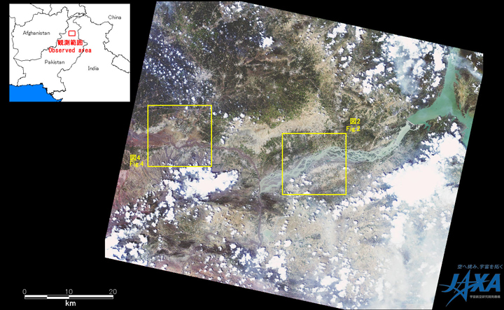
Fig.1: AVNIR-2 image with -28.0 degrees pointing angle acquired at 14:44 on August 5, 2010 (JST).
Yellow squares show location of Figs. 2 and 4.
(Click to View Enlarged Image)
Fig. 2 shows enlarged images of river basin at Kamra, Attock District, Punjab Province. Fig.3 shows enlarged images of Fig. 2 at a yellow box. They were assigned by channel 4, 3 and 2 for red, green and blue colors as false color composite. They can be clearly identified the swollen river since water region is seen like blue color. In comparison to Fig. 2 before as well as after disaster, the image taken after disaster indicates that width of rivers became wide and large region became flooded. Fig. 3 indicates that the large region shown by a yellow circle was flooded.
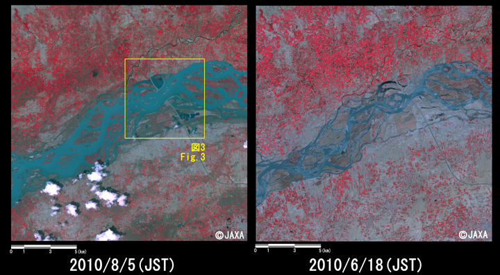
Fig.2: Enlarged images of the swollen rivers at Kamra, Attock District, Punjab Province
(324 square kilometers, left: August 5, 2010; right: June 18, 2010).
(Click to View Enlarged Image)
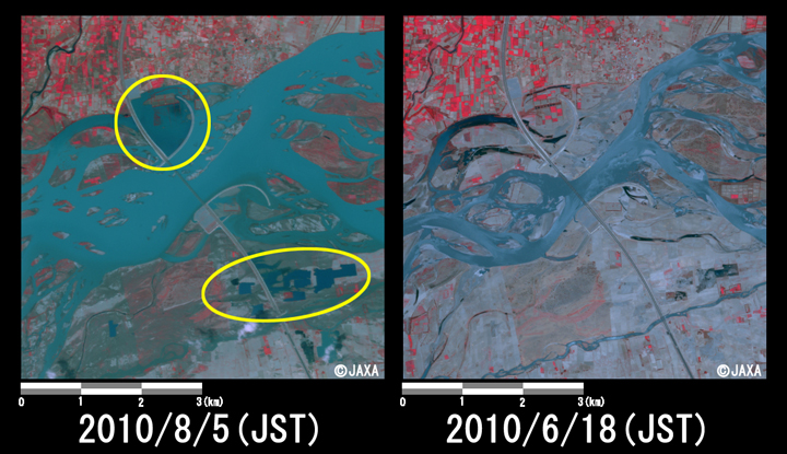
Fig.3: Enlarged images of the swollen rivers at Kamra, Attock District
(36 square kilometers, left: August 5, 2010; right: June 18, 2010).
(Click to View Enlarged Image)
Fig. 4 shows enlarged images of river basin at Nowshera District, Khyver Pakhtunkhwa Province. Fig.5 shows enlarged images of Fig. 3 at a yellow box.
In comparison to Fig. 4 before as well as after disaster, the image taken after disaster indicates that width of rivers became wide and large region became flooded. Fig. 5 indicates that rivers shown by a yellow circle was flooded and different flow channel became. If heavy rain continues, flood damages may be expanded.
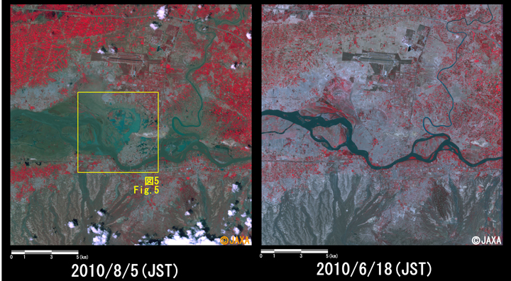
Fig.4: Enlarged images of the swollen rivers in Nowshera District, Khyver Pakhtunkhwa Province
(324 square kilometers, left: August 5, 2010; right: June 18, 2010).
(Click to View Enlarged Image)
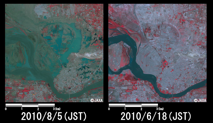
Fig.5: Enlarged images of the swollen rivers in Nowshera District
(36 square kilometers, left: August 5, 2010; right: June 18, 2010).
(Click to View Enlarged Image)
JAXA plans continuous observation of this area.
The acquired images were provided to International Center for Integrated Mountain Development (ICIMOD) via "Sentinel Asia".
* Advanced Visible and Near Infrared Radiometer type 2 (AVNIR-2):
AVNIR-2 is a visible and near infrared radiometer for observing land and coastal zones.
It provides 10-m spatial-resolution image and 70-km swath on the ground. The pointing angle of AVNIR-2 is +44 and - 44 degrees. This image was acquired by 28.0 degrees west.
[Reference]
2010/8/5: Emergency observation of concentrated heavy rain in Pakistan by AVNIR-2 onboard "Daichi" (ALOS).
©JAXA EORC
Copyright©1997- JAXA EORC All rights reserved.