Flash floods by the concentrated heavy rains occurred on June 15, 2010 (UTC) at the department of Var in the southern France, and this caused great damage. The Japan Aerospace Exploration Agency (JAXA) have performed the emergency observation to monitor the state of the damage by the Advanced Visible and Near Infrared Radiometer type 2 (AVNIR-2)* onboard the Advanced Land Observing Satellite (ALOS, "Daichi") on 19:15 (JST) or 10:15 (UTC) of June 17, 2010.
Fig. 1 shows an observed image of AVNIR-2 on 19:15 of June 17, 2010 (JST). It is the true colored composite using band 3, 2 and 1 of AVNIR-2. Although there are several clouds, which seem by white color in the image, there is no cloud in the department of Var and the ground could be seen.
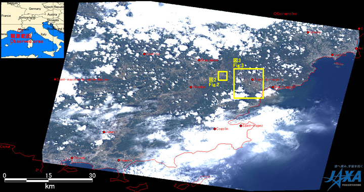
Fig.1: AVNIR-2 image with -28.0 degrees pointing angle acquired at 19:15 on June 17, 2010 (JST).
Yellow squares show location of Figs. 2 and 3.
(Click to View Enlarged Image)
Fig. 2 shows enlarged images of Le Muy in the southern France, which was taken after disaster on June 17, 2010 (left) and 21 days before on May 27, 2010. In comparison to the image before 21 days, May 27, 2010, a yellow circled area shows that the river overflowed and the urban area was flooded as the circled area seemed turbid in brownish.
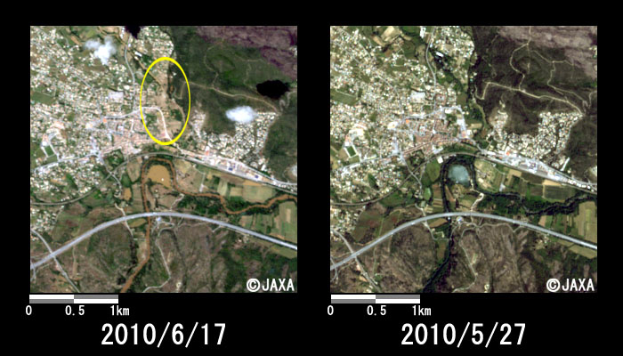
Fig.2: Enlarged images in Le Muy
(3km squares, left: June 17, 2010; right: May 27, 2010).
A yellow circled area shows location of floods.
(Click to View Enlarged Image)
Fig. 3 shows enlarged images in Puget-sur-Argens, which was taken on June 17, 2010 and May 27, 2010. In comparison to both images around disaster, since most fields seem like turbid in brownish, these might be caused by the concentrated heavy rains.
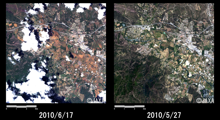
Fig.3: Enlarged images in Puget-sur-Argens
(10km squares, left: June 17, 2010; right: May 27, 2010).
(Click to View Enlarged Image)
JAXA plans continuous observation of this area.
The acquired images were provided to ALOS Data European Node (ADEN).
* Advanced Visible and Near Infrared Radiometer type 2 (AVNIR-2):
AVNIR-2 is a visible and near infrared radiometer for observing land and coastal zones.
It provides 10-m spatial-resolution image and 70-km swath on the ground. The pointing angle of AVNIR-2 is +44 and - 44 degrees. This image was acquired by 28 degrees east.
©JAXA EORC
Copyright©1997- JAXA EORC All rights reserved.