The Central Europe was seriously damaged due to floods caused by concentrated heavy rain, which had occurred since early Aug. 2010. The Japan Aerospace Exploration Agency (JAXA) has performed the emergency observation to monitor the state of the damage by the Advanced Visible and Near Infrared Radiometer type 2 (AVNIR-2)* onboard the Advanced Land Observing Satellite (ALOS, "Daichi") at 19:43 (JST) or 10:43 (UTC) on August 10, 2010.
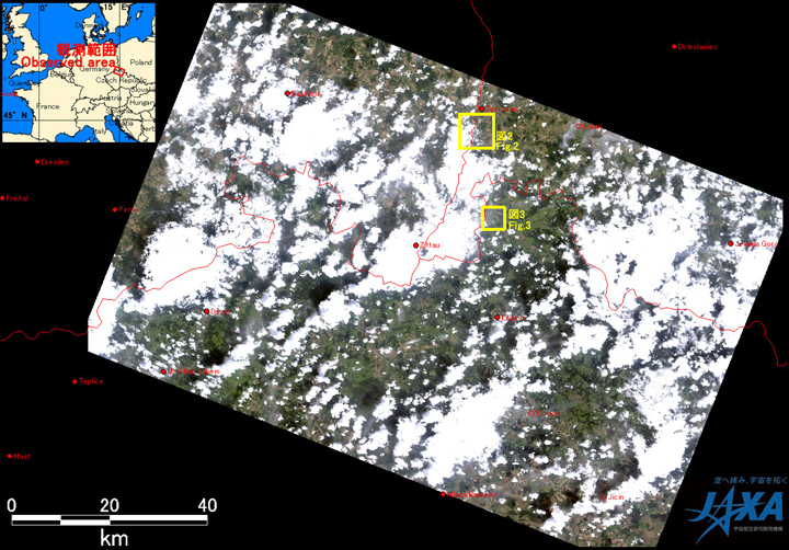
Fig.1: AVNIR-2 image with 37.0 degrees pointing angle acquired at 19:43 on August 10, 2010 (JST).
Yellow squares show location of Figs. 2 and 3.
(Click to View Enlarged Image)
Fig. 1 shows an observed image of AVNIR-2 at 19:43 on August 10, 2010 (JST). It was assigned by channel 3, 2 and 1 for red, green and blue colors as true color composite. Although most of Fig. 1 covered by clouds (seen by white color), swollen rivers, urban area and submerged farmland could be seen through the clouds.
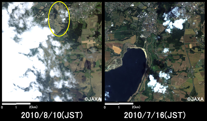
Fig.2: Enlarged images of the submerged area at Zgorzelec
(49 square kilometers, left: August 10, 2010; right: July 16, 2010).
(Click to View Enlarged Image)
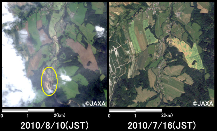
Fig.3: Enlarged images of the submerged area at Poustka
(16 square kilometers, left: August 10, 2010; right: July 16, 2010).
(Click to View Enlarged Image)
Both Figs. 2 and 3 are enlarged images of submerged areas, which were taken after disaster on August 10, 2010 (left) and before disaster on July 16, 2010 (right). Fig. 2 is located at Zgorzelec (on the boarder of Germany and Poland, about 190 km southeast from Berlin) and Fig. 3 is located at Poustka (about 105 km north-northeast from Praha). Both pair of images indicates that farmland was widely submerged. Yellow circles on the images show urban areas, which might be submerged.
The acquired images were provided to Czech Republic Ministry of the Interior via "The International Charter".
JAXA plans continuous observation of this area.
* Advanced Visible and Near Infrared Radiometer type 2 (AVNIR-2):
AVNIR-2 is a visible and near infrared radiometer for observing land and coastal zones.
It provides 10-m spatial-resolution image and 70-km swath on the ground. The pointing angle of AVNIR-2 is +44 and - 44 degrees. This image was acquired by 37 degrees east. The image taken before disaster on July 16, 2010 was acquired by 0.0 degree.
©JAXA EORC
Copyright©1997- JAXA EORC All rights reserved.