Data Application Researches
3. Digital Elevation Model (DEM) and Mapping
Digital Elevation Model (DEM) Derived by the SAR Interferometry
3. Digital Elevation Model (DEM) and Mapping
Digital Elevation Model (DEM) Derived by the SAR Interferometry
Mt. Fuji DEM using the SAR Interferometry
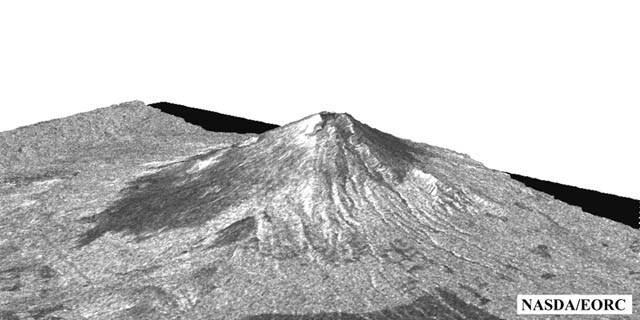
Fig. 1: Mt. Fuji DEM derived by the SAR interferometry.(Click to View Enlarged Image)
 A SAR interferogram (phase difference) contains information on the height, surface deformation, and water vapor distribution. Although the interferometric condition depends on the base line, signal quality, and temporal changes of the target, a good interferogram can provide height information. This figure is the height information derived from the SAR data acquired on Sept. 7, 1995 and Oct. 27, 1995, and overlaid by the amplitude image.
Extract from the JERS-1 Earth View published NASDA EORC
©JAXA EORC