12. Application Research using Geographical Information
Series of World Heritage from Space / Pyramid Fields
- The pyramid fields from Giza to Dahshur [Egypt] -
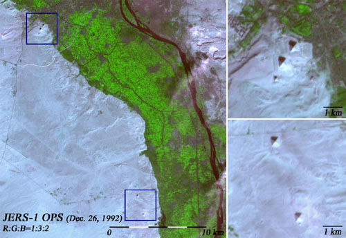
Fig. 1: The pyramid fields from Giza to Dahshur.
(Click to View Enlarged Image)
 These images of the pyramid were taken on December 26, 1992, by the OPS onboard JERS-1. The farmlands watered by the rich Nile river show the high contrast with the Sahara desert spreading out to the west, and number of pyramids are located in the desert along the boundary. The right side images are the enlarged view of the several famous pyramids which is flamed in by blue rectangle in left image. The upper image shows the Giza area famous for the three great pyramids, that is, the pyramids of King Khufu, King Khafre, and King Menkaure (from the top right to the bottom left). Thelower image shows the Red Pyramid (top) and the Bent Pyramid (bottom) in Dahshur area which were constructed by King Sneferu. The enormous tomb of the ancient king shows the clear contrast.
between light and shadow due to its beautiful shape and it can be observed clearly by satellite. Memphis and its necropolis were registered as the World Heritage in 1979.
©JAXA EORC