11.Hydrology and Water Resource Management
Flood Duration in the Jau River, Amazon
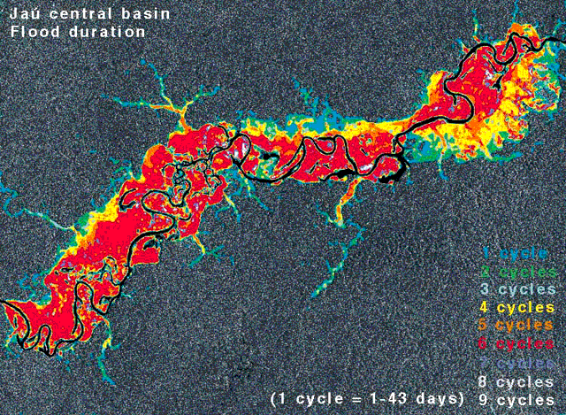
Fig. 1: Flood duration in the Jau River, Amazon, Brazil.
(Click to View Enlarged Image)
 The water levels of the Amazon River and its tributaries may vary 8 to 10 meters between the dry and rainy seasons, resulting in annual inundation of extensive forest areas on the floodplain. Such flooded environments both permanently flooded and those subject to seasonal flooding provide important habitat for aquatic flora and fauna and play a key role in sustaining regional fish production. They are also a globally significant source of methane and other trace gases essential to climate regulation.
Accurate information on wetland distributions is currently needed to improve estimates of habitat availability and calculate regional contributions of trace gases to the troposphere. However, a good estimation of the exact amount has been impossible to obtain due to insufficient knowledge of the temporal and spatial dynamics of this yearly inundation.
Radar sensors penetrate not only cloud cover, but also the forest canopy, which makes it possible to distinguish forest areas with water below the canopy from areas that are dry. This image shows the Jau River on the Amazon flood plain, and the spatial variation of inundation the area is exposed to during one year. The water level in the Jau varies up to 8 meters between high and low water, and the colors indicate the duration of flooding in the area. The information has been derived from a 1-year time-series of radar images. This constitutes the first time that the spatial and temporal distribution of forest inundation has been mapped in the Jau River.
As a next step, the work approach developed here will be applied to cover the entire Amazon basin using basin-wide radar mosaics to a aim of providing substantially better estimates of inundation patterns on a semi-continental scale. This type of information is required as input in climate change modeling, and in particular for estimations of natural emissions of methane.
Extract from the JERS-1 Earth View published by NASDA EORC
©JAXA EORC/JRC