
Emergency observation and initial flood assessment in the Barun river basin, Nepal by ALOS-2
Posted: May 17, 2017, 7:30 (UTC)
Overview
- A large-scale flash flood was reported in the Barun River (a Major tributary of the Arun River) in Nepal on Apr. 20, 2017 (Local time).
- Emergency observation of PALSAR-2 onboard ALOS-2 was performed on Apr. 25, 2017 by JAXA, corresponding to a request via Sentinel Asia.
- Remarkable areal change on a glacial lake is recognized.
- The lake area increased between 2008 and 2017 and then decreased between Apr. 18 and 25 in 2017.
- Flood debris sediment is recognized at the downstream.
- This analysis suggests that a glacial lake outburst flood occurred.
Corresponding to an emergency request from Sentinel Asia related to a large-scale flood reported caused on Apr. 20, 2017 in the Barun river basin, Nepal the Japan Aerospace Exploration Agency (JAXA) performed an emergency observation at 6:06 (GMT) on Apr. 25, 2017 by means of the Phased Array type L-band Synthetic Aperture Radar-2 (PALSAR-2) aboard the Advanced Land Observing Satellite-2 (ALOS-2, "DAICHI-2").
To assess changes of glacial lakes in the upstream basin, lake outline was delineated manually from the acquired image, which was orthorectified and geo-corded (L2.1) (Fig. 1). In a PALSAR-2 backscatter amplitude image, lakes are shown as homogeneously dark areas, because low backscatters return from the water surface, which enables manual delineation of lake outlines from an amplitude image. In addition, areal changes over the flood were analyzed with this image and those acquired by ALOS/PRISM (Jan. 5, 2008 (Fig. 2); Feb. 22, 2009 (Fig. 3)), PALSAR-2 (Dec. 23, 2014) (Fig. 4), and Sentinel-2 (Apr. 18, 2017 (Fig. 5); May 8, 2017 (Fig. 6)).
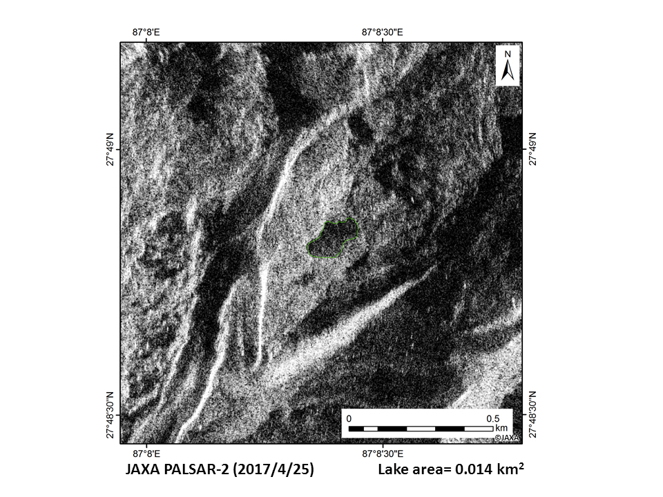 Fig.1: The ALOS-2/PALSAR-2 image (Apr. 25, 2017), which was orthorectified and geo-corded (L2.1).
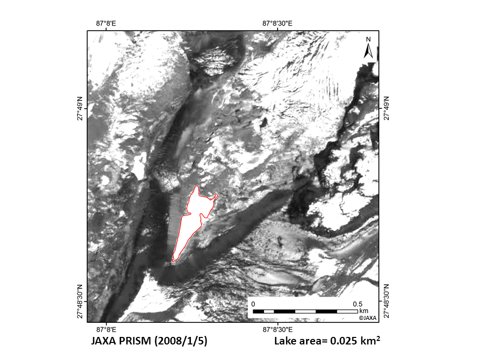 Fig.2: The ALOS/PRISM image (Jan. 5, 2008).
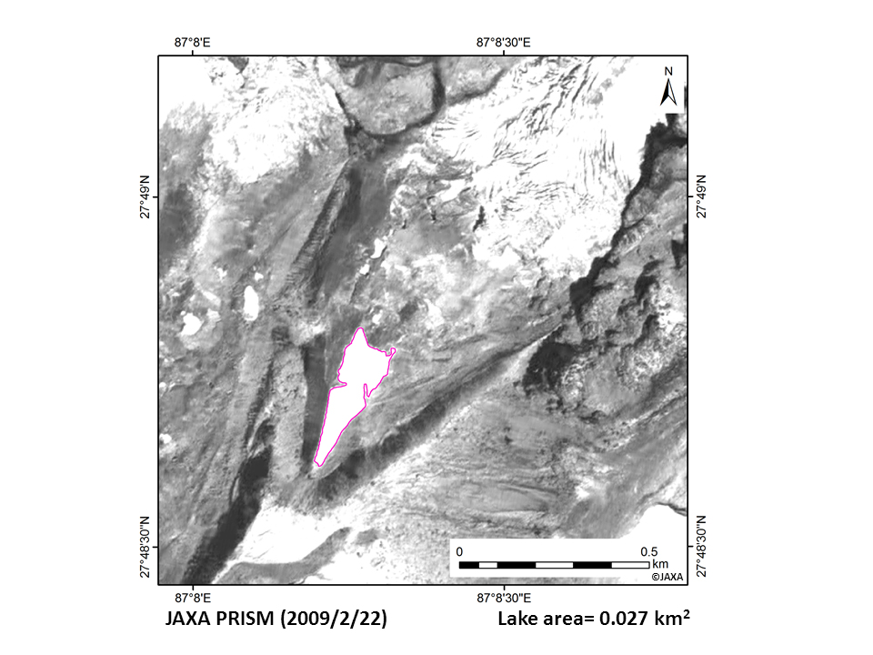 Fig.3: The ALOS/PRISM image (Feb. 22, 2009).
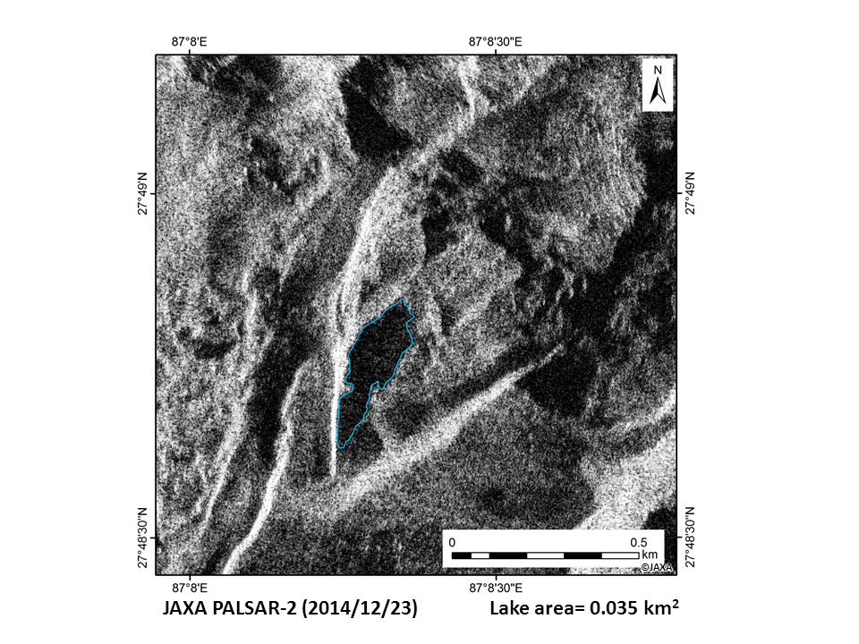 Fig.4: The ALOS-2/PALSAR-2 image (Dec. 23, 2014).
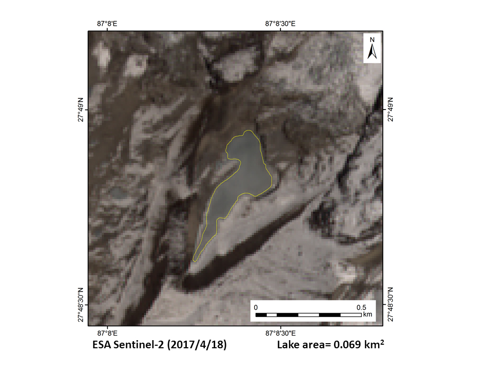 Fig.5: The Sentinel-2 image (Apr. 18, 2017).
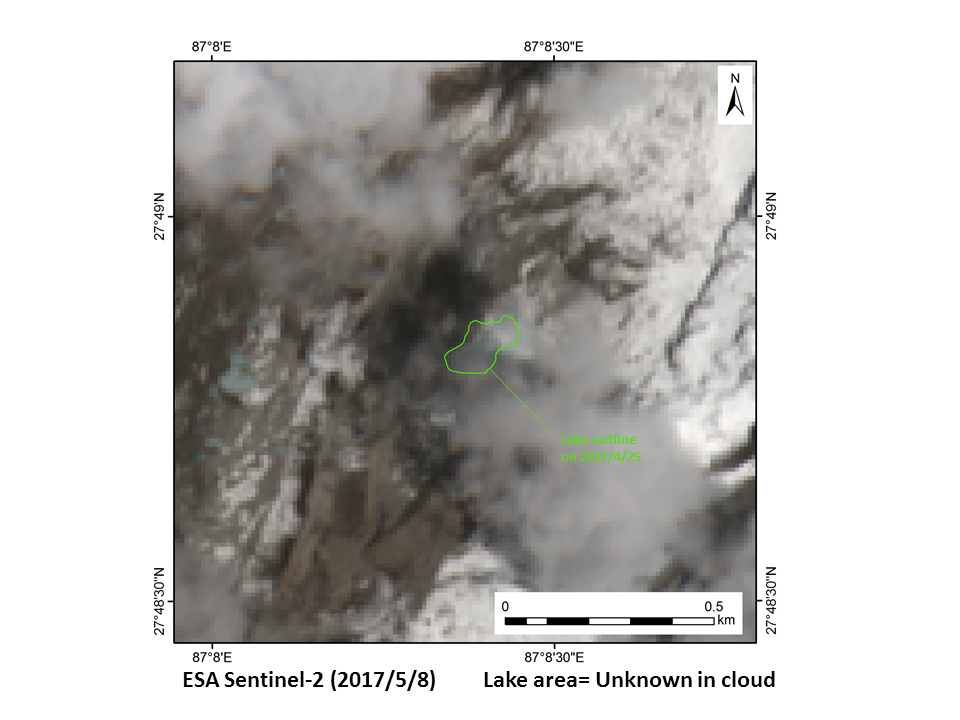 Fig.6: The Sentinel-2 image (May 8, 2017).
Remarkable areal increase before the flood and decrease over the flood were recognized from these images (Fig. 7). Therefore, this lake located at [27.812ºN, 89.138ºE] has a high potential as the source of the flood. The Sentinel-2 image after the flood denotes debris sediments along the downstream river stream (Fig. 8), compared with that acquired before the flood (Fig. 9). This analysis thus suggests that this is a glacial lake outburst flood (GLOF). More detail investigations including field surveys are necessary to reveal and understand this event scientifically.
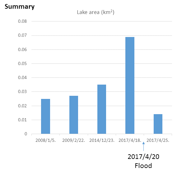 Fig.7: Temporal change of the glacial lake located at [27.812ºN, 89.138ºE].
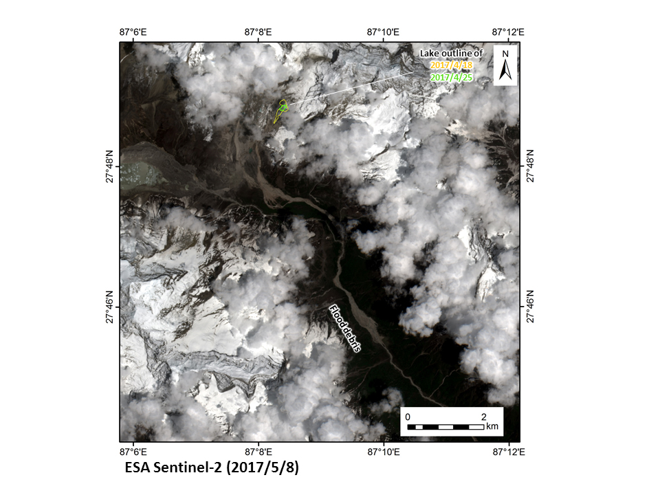 Fig.8: The Sentinel-2 image after the flood (May 8, 2017).
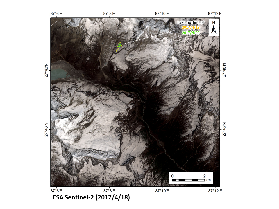 Fig.9: The Sentinel-2 image before the flood (Apr. 18, 2017).
The PALSAR-2 data acquired from the emergency observation was immediately sent to a local organization via Sentinel Asia. JAXA contributes for hazard response activities by rapid observations on such a mountain hazard in remote regions in cooperation with concerned authorities.
© JAXA EORC
© Copyright 1997- All Rights Reserved.