
ALOS-2/PALSAR-2 Observation Results of the 2015 Nepal Earthquake (2)
Summary:
- ALOS-2/PALSAR-2 observed eastern Nepal to detect the surface deformation associated with the earthquake.
- Detected deformation extends to approximately 170 km east-southeast from the epicenter.
- The extension and shortening of the satellite-ground distance were observed at the southern and northern part of the fault, respectively.
The Japan Aerospace Exploration Agency (JAXA) has been performing observations with the Phased Array type L-band Synthetic Aperture Radar-2 (PALSAR-2) aboard the Advanced Land Observing Satellite-2 (ALOS-2, "DAICHI-2") for monitoring the effects of an earthquake struck Nepal on April 25, 2015 (local time). The emergency observations were requested from Sentinel Asia and the International Charter.
We applied an interferometric analysis to the PALSAR-2 data obtained with ScanSAR mode before (May 31, 2015) and after (April 28, 2015) earthquake to detect the deformation associated with the earthquake. The ScanSAR interferometry, which has been made possible by the highly synchronized observation beams of PALSAR-2, enable us to monitor over 350 km swath at once.
Figure 1 shows the whole interferogram. Colored fringes denote the change of the line-of-sight (LoS) distance (distance between the satellite and the ground) between April 28 and March 31. In the lower left part (the east from Kathmandu), fringes possibly caused by the earthquake are visible. Large fringes in the right part of the figure are probably not tectonic fringes but remaining orbital fringes*1 and ionospheric effects*2.
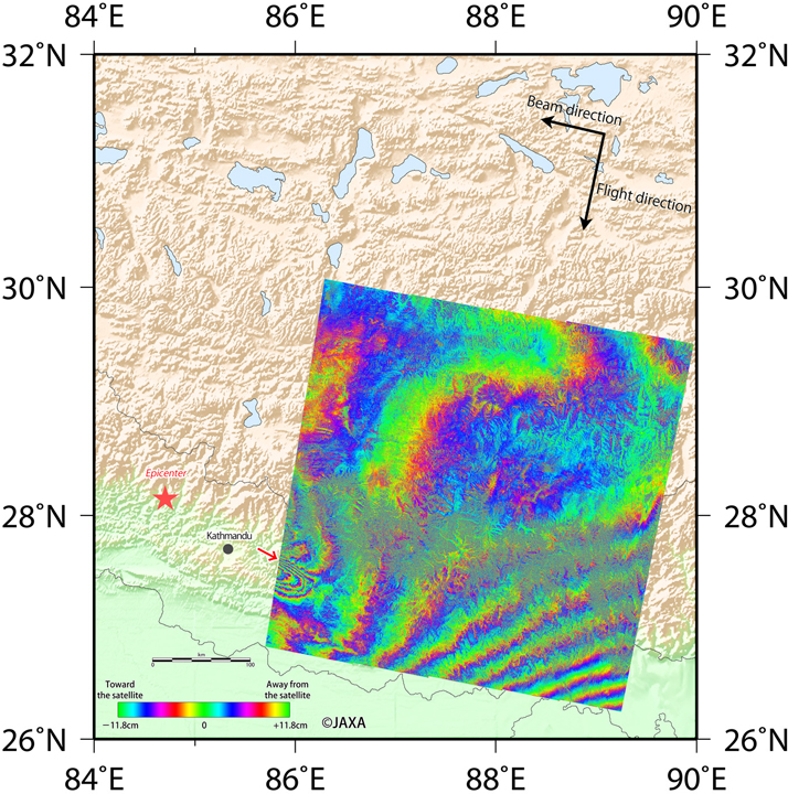 Fig.1: Interferometric analysis result from the PALSAR-2 data acquired between
pre- (Mar. 31) and post- (Apr. 28) seismic.
(Click to view enlarged image)
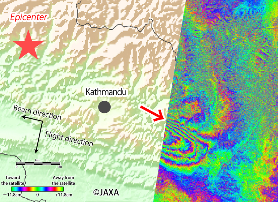
Figure 2 is the close up image of the deformation part in the Figure 1. There are two fringes which patterns are opposite. The northern fringes show extension of the LoS distance approximately 2 cycles (24 cm). Contrarily, the southern fringes show shrink of the LoS distance approx. 4 cycles (48 cm). These patterns indicate that the deformation reached to about 170 km east-southeast from the epicenter.
(Click to view enlarged image)
JAXA will continue the observation at this area and the next interferometric observation covering the epicenter is now scheduled for May 2, 2015 (GMT). JAXA will provide PALSAR-2 images and results to relevant organizations and this website.
(*1) Onboard GPS data may have some errors which leads miscalculation of the orbital fringes in the interferogram.
(*2) Ionosphere sometimes affects the propagation of the microwave used by PALSAR-2, which leads unpredictable change of the interferogram.
See also:
The 2015 Nepal Earthquake: Crustal deformation detected by ALOS-2 data (Geospatial Information Authority of Japan) http://www.gsi.go.jp/cais/topic150429-index-e.html
© JAXA EORC
© Copyright 1997- All Rights Reserved.