| (1.1MB) | |
NASDA,NASA/JPL September 21,22 1996 | ||
| (829KB) | |
NASDA,NASA/JPL September 21,22 1996 |
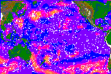
The image is based on preliminary processing of the first set of NSCAT observations, using prelaunch model function and calibration. Improvement is expected after the standard calibration and beam balancing procedures. The image is produced by objective interpolation as described by Tang and Liu [JPL Publication 96-19, 1996] based entirely on NSCAT data. This preliminary analysis clearly demonstrates that the high spatial resolution of NSCAT data improves the monitoring of sever storms, such as typhoons, which are usually grossed over by conventional methods. It also shows that the repeated global coverage provides a better description of atmospheric circulation over ocean that is not adequately sampled in the past.
| (112KB) | |
September 20, 1996 |
| (145KB) | |
| (1.5MB) (Quicktime) |
|
Measured by NSCAT September 20, 1996 |
| (1.4MB) (Quicktime) |
|
Measured by NSCAT September 20, 1996 |
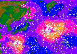
The first images of winds over the oceans taken by the NASA Scatterometer (NSCAT) science instrument onboard Japan's Advanced Earth Observing Satellite (ADEOS) show two typhoons in the northwest Pacific Ocean as they were seen on September 20.
Typhoon Violet eventually ran into the coast of Japan, killing several people and causing severe property damage. Typhoon Tom was observed in the open ocean east of Japan. The scatterometer measured winds in the storms at about 60 miles per hour.
"We are very pleased with the quality of these first images." said Jim Graf, NSCAT project manager at NASA's Jet Propulsion Laboratory (JPL), Pasadena, CA. "These images are typical of the operational data that will be generated using NSCAT and then made available to meteorologists all over the world. NSCAT will provide regular measurements of ocean surface wind speeds from space, which will enhance the ability of weather forecasters to predict the behavior of storms such as Typhoon Violet. In addition, Earth science researchers will use NSCAT data to better understand climate changes occurring on our planet."
The scatterometer takes 190,000 wind measurements per day, mapping more than 90 percent of the world's ice-free oceans every two days. The instrument will provide more than 100 times the amount of ocean wind information currently available from ship reports. Since the scatterometer is a radar instrument, it is capable of taking data day or night, regardless of sunlight or weather conditions.
"This preliminary analysis of the first set of NSCAT data clearly demonstrates that the high resolution of the NSCAT instrument improves the monitoring of severe storms, such as typhoons. It also shows that the repeated global coverage provides a better description of atmospheric circulation over the oceans, which has not been adequately sampled in the past, and it contributes to a better understandng of air-sea interactions," said Dr. W. Timothy Liu, NSCAT project scientist at JPL.
Information gathered by the scatterometer is being used by the National Weather Service, an office of the National Oceanic and Atmospheric Administration (NOAA), and the Japanese Meteorological Agency. NOAA processes the data from the scatterometer and distributes related products to researchers around the globe. The ocean surface wind measurements, used in numerical computer models, will help weather forecasters more accurately predict the path and intensity of hurricanes, winter storms and other weather systems that form over the oceans.
ADEOS is an international global change research mission of the National Space Development Agency of Japan (NASDA), which includes instruments from the United States, Japan and France, with investigators from many other countries. The satellite is a key part of an international environmental research effort that includes NASA's Mission to Planet Earth (MTPE) program, a long-term, coordinated research effort to study the Earth as a global environmental system. The goal of MTPE is to develop a better scientific understanding of natural environmental changes and to distinguish between natural and human-made changes and impacts.
MTPE-related data, which NASA distributes to researchers worldwide, is essential to helping people make better informed decisions about the environment. NSCAT data will be distributed by NASA and NASDA.
The Jet Propulsion Laboratory developed, built and manages the NSCAT instrument for NASA's Office of Mission to Planet Earth, Washington, DC.
Comments to: adeossupport@eorc.nasda.go.jp
Last Update: 07 October 1996